 | 17 Nov 2025
Mapping Critical Raw Materials (CRM) hard rock deposits in Europe
Guillaume Bertrand
Hervé Berthier
Daniel P. S. de Oliveira
Jørgen Tulstrup
This article presents the new version of the map of critical raw materials hard rock deposits that has been produced in the frame of the GSEU project (Geological Service for Europe). The map displays over 800 medium to very large deposits for 30 Critical Raw Materials (CRM) from the 2023 list of the European Commission, in 33 European countries. We explain the objective of this work and the process and methodology for collecting, compiling and harmonizing CRM data from multiple providers. We also describe the map itself, the information it carries and its availability. As an example of added-value output, we present a pan-European assessment of CRM potential, classified in 4 categories of confidence from “historical or non-compliant resource estimates” to “mineral reserves”. This assessment provides an image of the current known potential for CRM in Europe. Based on this exercise, we discuss the challenges and barriers of compiling and harmonizing mineral resources data at continental scale, and the future perspectives of this work we envision through the EGDI (European Geological Data Infrastructure). We also discuss the limitations of the map and dataset to raise awareness on their proper interpretation and use.
- Article
(2476 KB) - Full-text XML
-
Supplement
(442 KB) - BibTeX
- EndNote


In an era marked by rapid technological advancement and the transition to a green and digital economy, the raw materials supply chains are under unprecedented pressure. Many of these materials are deemed critical due to their essential role in key industries and the high risks associated with their supply. The concern for Europe regarding these raw materials has prompted the publication of Critical Raw Materials (CRM) lists since 2011 with a periodicity of approximately three years (European Commission, 2011, 2014, 2017, 2020, 2023). For Europe, securing access to these CRM has become a strategic imperative. The continent's dependence on external suppliers, particularly from geopolitically sensitive regions, has exposed vulnerabilities that threaten its industrial base, energy transition, and long-term competitiveness.
The Geological Service for Europe (GSEU) is a European co-funded project aimed at establishing a permanent, integrated, and sustainable geological service to support EU policies and strategic goals. Launched in 2022, GSEU brings together 48 national and regional European geological surveys and public authorities. One of the primary motivations behind GSEU is the recognition that robust geological data and expertise are essential for informed decision-making, particularly in areas such as critical raw materials, land use planning, climate adaptation, and environmental protection. The uneven distribution of geological information across countries and the lack of interoperability among national geological datasets have long been barriers to coordinated action at the EU level. By integrating and harmonizing these datasets into one global data infrastructure, the European Geological Data Infrastructure (EGDI, developed by EuroGeoSurveys in 2016 and further extended under the GeoERA programme), GSEU aims to create a comprehensive and coherent geological knowledge base that can be used by policymakers, industry stakeholders, and the research community alike.
This article presents the updated dataset and map of CRM hard rock deposits that was produced within the frame of the GSEU project. It explains the needs and context that underline this work, it describes the process to compile the data and build the map, and it details their benefits and limitations. Importantly, this map is intended as a communication tool for non-experts to support potential assessment, knowledge dissemination, and integration into broader EU initiatives such as the Regulation (/EU) 2024/1252, known as the Critical Raw Materials Act (Official Journal of the European Union, 2024a), the European Green Deal (European Commission, 2019), and the Net Zero Industry Act (NZIA; Official Journal of the European Union, 2024b).
A major focus of the GSEU project is to develop a pan-EU assessment for mineral resources potential, particularly focusing on CRM. The work of compiling and harmonizing data on mineral resources covering the whole European territory was initiated over a decade ago with the ProMine project, which resulted in the ProMine “Mineral Deposit” (MD) database, describing primary mineral resources in 34 European countries using common data models and lexicons (Cassard et al., 2015). The ProMine MD database allowed the production of the first maps of CRM deposits in Europe, based on the 2011, 2014 and 2017 EU CRM lists (Cassard et al., 2015; Bertrand et al., 2016). Despite the large number of records provided during ProMine (∼ 13 000) and subsequent EU-funded projects (e.g. Minerals4EU, EURare, GeoERA; see Wittenberg et al., 2022) that improved both the data and the database model, one weakness was that the data compilation at continental scale was undertaken by only a handful of partners, without direct systematic involvement of national geological surveys that are the main data providers. Within GSEU, a large effort has been made to involve the network of European Geological Survey Organisations (GSO) in the data collection process. Instead of querying a database established by a third party, the dataset for this map was collected based on individual project partner contributions. The 2024 map of CRM deposits in Europe presented here, based on the 2023 EU CRM list, thus reflects more closely than ever the availability and quality of knowledge of primary CRM deposits of European GSO.
2.1 Terminology and definitions
Some terms essential to the proper understanding of this article are briefly described below. The definitions follow their use by the minerals industry and the resource assessment community.
Mineral occurrence
A concentration of any useful mineral found in bedrock in sufficient quantity to warrant further exploration.
Mineral deposit
A mineral occurrence of sufficient size and grade that it might, under the most favourable circumstances, be considered to have economic potential.
Mineral resource
Resources whose location, grade, quality, and quantity are known or can be estimated from specific geological evidence. A resource is that amount of a mineral occurrence that exists in both identified and undiscovered deposits. The distinction between inferred, indicated and measured resources reflects an increasing degree of confidence in their occurrence, which is often correlated with the amount of exploration activities that have been carried out on that particular deposit (e.g. drilling).
Mineral reserve
Portion of a mineral resource that can be realistically and economically mined. Reserves refer to that part of a resource, which have a known size, and can be exploited at a profit. At any given moment, part of the resources may be excluded from the reserves due to cost reasons (inaccessibility or difficult extraction, etc.) or quality (low grade, presence of a penalizing mineral, etc.). However, this situation can evolve with economic factors such as rising commodity market value, technological advances (new exploitation or processing methods), or an administrative change such as a land acquisition that provides access to these resources.
2.2 Deposit size
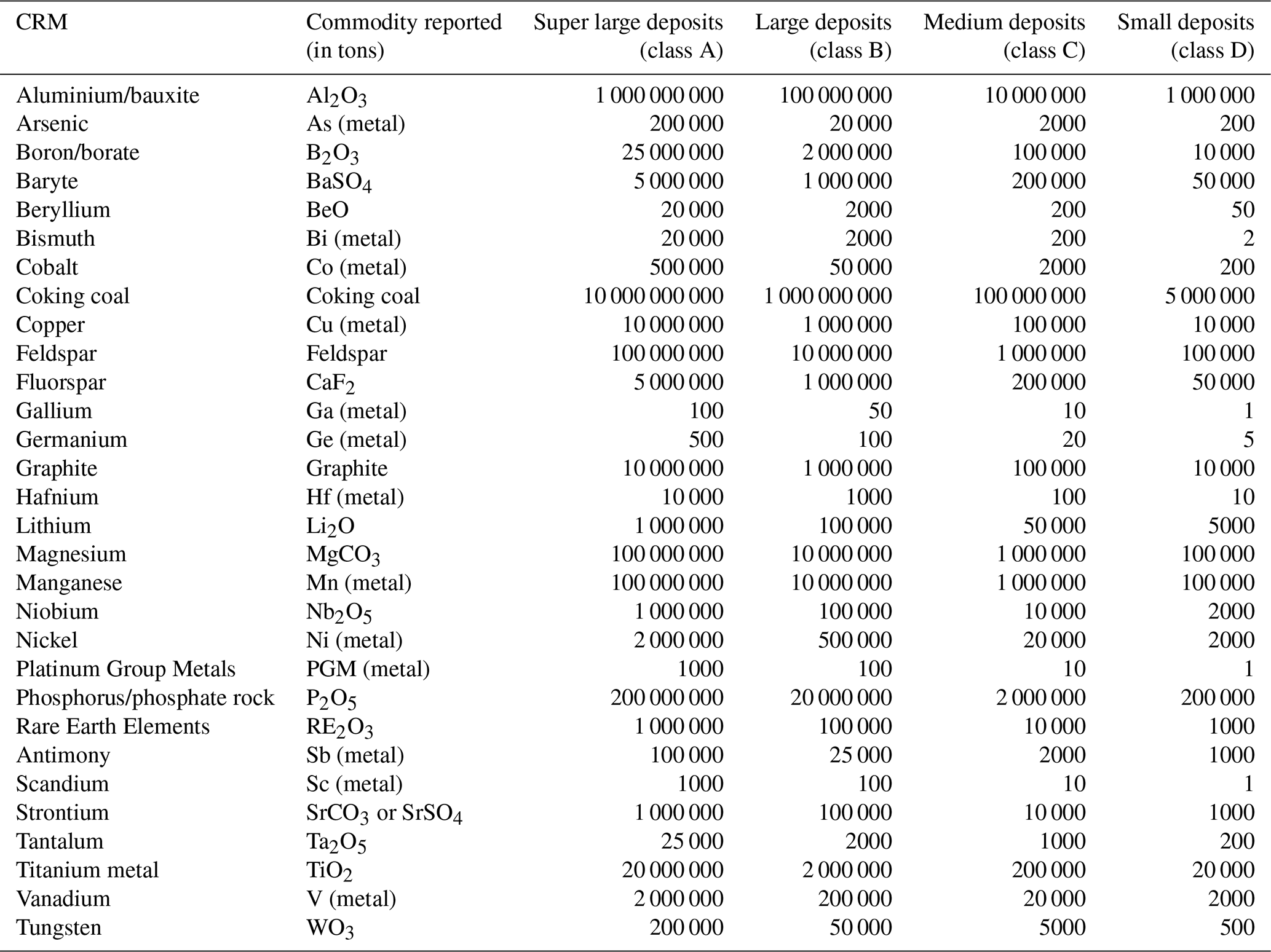
To compare the mineral potential of deposits across borders, several attempts to classify their magnitude categories have been made (Laznicka, 2010). Since the early 2010s, Europe has adopted a classification system based on the total endowment (Cassard et al., 2015) – estimated by the sum of cumulative production, resources and reserves of commodity contained – in which mineral deposits have been discriminated in five size classes (A: super large, B: large, C: medium, D: small, E: showing). This classification system was first coined in the late 1990s for the needs of global metallogenic syntheses (Milési and Deschamps, 2001) and was reviewed in the late 2000s using the work of Rundqvist et al. (2006). For each commodity, these classes were defined by calibration on known deposits and refined after statistical examination of the distribution of the different classes. This classification method, designed for prospectivity assessment, ignores the prevailing economic conditions, which are extremely variable, and differs from classifications based on annual production rates, subject to market influences. Importantly, this prospectivity-focused approach also accounts for materials that may have already been extracted - not just what remains. In other words, a large deposit does not necessarily represent available material for extraction – it may reflect a deposit that has already been partially or completely mined out, or conversely, it may represent untapped potential. This gives a complete picture of the original endowment, which is a geological indicator necessary to identify new prospective areas. The threshold values of these classes for the selected CRM are given in Table 1. These values are taken from the lexicon “ImportanceValue” (European Commission, 2024). In the case of a deposit composed of several commodities, several size classes are calculated (one for each commodity).
2.3 Data collection and processing
Data collection was largely based on contributions from national and regional Geological Survey Organisations (GSO). GSO were requested to provide information on CRM deposits sized super large (class A), large (class B) and medium (class C). Specifically, GSO were requested to provide the following information for each deposit (to facilitate data processing and harmonisation, most fields that contained text values (i.e. non numerical) were lexicon guided):
-
Name and coordinates (latitude and longitude, in WGS84 decimal degrees format)
-
Commodity (one entry per commodity. Deposits composed of several commodities require several entries)
-
Deposit size (calculated per commodity, based on the tonnage threshold values in Table 1)
-
Resources:
- –
Commodity tonnage + type of commodity reported (e.g. in oxide or element form)
- –
Commodity grade
- –
Resource category (lexicon guided; see Table S1 in the Supplement)
- –
Resource classification method (lexicon guided; see Table S2)
- –
-
Reserves:
- –
Commodity tonnage + type of commodity reported
- –
Commodity grade
- –
Reserve category (lexicon guided; see Table S3)
- –
Reserve classification method (lexicon guided; see Table S2)
- –
-
Former production (cumulative):
- –
Commodity tonnage + type of commodity reported
- –
Commodity grade
- –
The availability and quality of knowledge varies between countries. For 75 % of the records in this dataset, we received data on resources/reserves, and/or in some cases on former production. For the remaining 25 % of records, either the tonnage data was confidential (18 %), or no information was provided (7 %). To ensure full geographic coverage, for the latter we used data from the ProMine Mineral Deposit database (Cassard et al., 2015) for the following countries: Bosnia & Herzegovina, Bulgaria, Ireland, Kosovo, Montenegro and North Macedonia. For those records, only the name, coordinates, commodities contained and associated deposit size are available (no tonnage figures).
To ensure that the level of knowledge and representation was similar throughout Europe, data processing and verification, as well as attribute harmonisation was required. The verification process included:
-
Harmonisation of attributes “type of commodity reported”. Commodity tonnages are expressed in different ways, e.g. a commodity is described in either its oxide or element form. For example, phosphate rock/phosphorous can be expressed in tons of phosphorus pentoxide (P2O5) or tons of elemental phosphorus (P). Some conversions were necessary to ensure data comparability, including comparability to the deposit size threshold values in Table 1.
-
Manual calculation of total endowment, and verification/correction of deposit size class. The total endowment of a deposit is the sum of its resources, reserves (if not already counted as part of the resources) and former commodity production (cumulative). The size of a deposit for a given commodity is based on the total endowment (Table 1).
The map of CRM hard rock deposits in Europe presents an assessment of the domestic potential of Europe for critical raw materials. It covers the land areas of the following countries: Albania, Austria, Belgium, Bosnia & Herzegovina, Bulgaria, Croatia, Cyprus, Czech Republic, Denmark (including Greenland), Estonia, Finland, France, Germany, Greece, Hungary, Ireland, Italy, Kosovo1, North Macedonia, Montenegro, the Netherlands, Norway, Poland, Portugal, Romania, Serbia, Slovakia, Slovenia, Spain, Sweden, Switzerland, Ukraine and the United Kingdom. Note, apart from Greenland, overseas departments and territories were excluded from the geographical scope, which focuses on continental Europe and nearby islands.
A total of 30 CRM were evaluated (Table 1). They correspond to 32 out of the 34 CRM from the EU list (European Commission, 2023). Even though a distinction is made in the EU CRM list, the Heavy and Light Rare Earth Elements (HREE & LREE, respectively) were assessed as a group, because they commonly occur together in mineral deposits. Similarly, phosphate rock and phosphorus are sourced from the same deposit types (the latter is derived from processing the former), so these two CRM are considered together. Helium (traditionally sourced from the processing of natural gas) and silicon metal (produced from high purity quartz) resources in Europe were not addressed in this assessment due to the lack of data available. Consequently, the 30 commodities considered in the dataset and map of CRM hard rock deposits in Europe covers 32 out of the 34 CRM of the European Commission (2023).
The map of CRM hard rock deposits in Europe is a visual representation of deposits of the 30 CRM in scope, with symbols sized according to their class and coloured according to their commodity. It shows more than 800 deposits of medium, large and very large size, across 33 European countries. Where a deposit contains multiple commodities, and wherever possible, the symbols are stacked so that the smallest ones are visible on top. The map has been released as pdf documents in two sizes: A3 for digital communication (Fig. 1), and A0 for full-size poster prints (both available for download at https://doi.org/10.5281/zenodo.15222112, Albert and Bertrand, 2025b). The A0 size version uses as background layer the 1 : 1 500 000 Geological Synthesis for Europe compiled by BRGM (Billa et al., 2008) that includes lithology polygons and tectonic structures. It also contains the deposit names (where deposits have multiple names, they are labelled using their most commonly used one). The map is provided under Creative Commons CC BY 4.0 license that requires proper attribution and allows to adapt and share it in any format for any usage. It is openly accessible on the Zenodo online repository platform (https://doi.org/10.5281/zenodo.15222112, Albert and Bertrand, 2025b). Also, as the map is only a visual – and necessarily incomplete – representation of the data, the full dataset it is based upon is also freely accessible on the Zenodo platform (https://doi.org/10.5281/zenodo.15234833, Albert and Bertrand, 2025c).
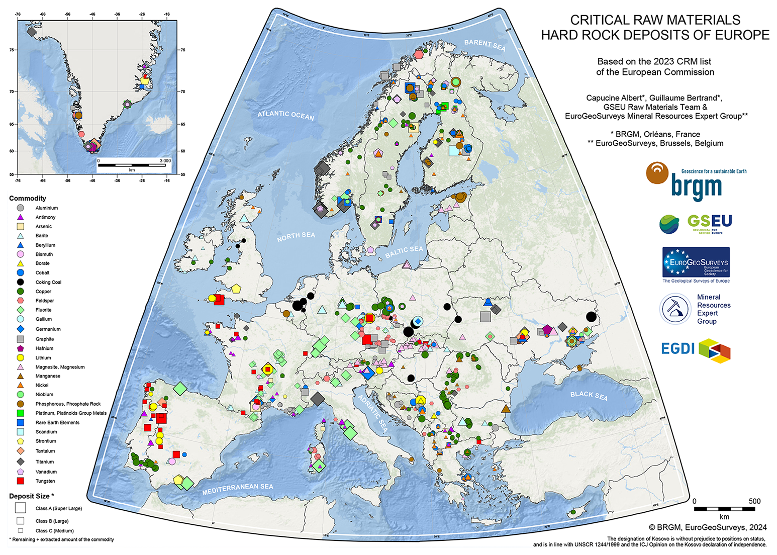
Figure 1Map of Critical Raw Materials hard rock deposits of Europe 2024, based on the 2023 list of CRM from the European Commission (2023). Commodities are differentiated by shape and colour, with symbols sized according to the deposit size. © BRGM, EuroGeoSurveys, 2024.
The map highlights countries and regions in Europe that are of potential interest for domestic extraction of CRM. Such geographic associations are, for instance, lithium, tungsten and fluorite deposits that highlight the potential in segments of the western European Variscan Belt (e.g. Iberian Massif in Spain and Portugal, Armorican Massif and Massif Central in France, Bohemian Massif in Czechia and neighbouring regions). Similarly, the copper deposits in southern Portugal and western Andalucia (Spain) nicely highlight the Iberian Pyrite Belt, a major metallogenic province for VMS (Volcanogenic Massive Sulphide) deposits. In southwestern Poland, the cluster of copper deposits nicely highlight the potential of the Kupferschiefer sedimentary formation of Silesia. Widespread rare earth elements and copper deposits in the Fennoscandian shield (Norway, Sweden and Finland) highlight the important and distributed potential of this region. As such, the map illustrates the existence and spatial distribution of CRM potential in Europe, either past, present or future.
Obtaining a reliable resource assessment for Europe as a whole is very challenging, partly because the available data across multiple countries follows different industry standards with inconsistent reporting parameters, making them difficult to reconcile with international reporting templates (e.g. CRIRSCO-aligned classification systems, United Nations Framework Classification for Resources (UNFC)). Moreover, some degree of subjective interpretation is inevitable, particularly when assessing historical figures. For this assessment, we aggregated the resources/reserves figures into four categories, reflecting an increasing degree of confidence in the estimates: (1) mineral reserves, (2) mineral resources, (3) compliant historic estimates, and (4) historical or non-compliant resource estimates. The aggregated figures are compiled in Table 2. In details, the above-mentioned categories include the following:
(1) Mineral reserves
Reserves available (active mining) or likely available for extraction (licensing allowing), including:
-
Proven and probable reserves (CRIRSCO-compliant classification systems, e.g. JORC, NI 43-101, PERC, CIM)
-
Approved mineral reserves of the A, B, C1 and C2 categories (Russian NAEN code)
-
UNFC 111 and 112 (i.e. “viable projects”)
(2) Mineral resources
Resources that are in development for extraction, including:
-
Measured, indicated and inferred resources (CRIRSCO-compliant classification systems, e.g. JORC, NI 43-101, PERC, CIM)
-
Not-approved mineral resources of the A, B, C1, C2 and D categories (Russian NAEN code)
-
UNFC 221, 222 and 223 (i.e. “potentially viable projects”)
(3) Compliant historic estimates
Previously estimated resources, which require revisions and adaptations to ensure feasibility, including:
-
Prospected resources of the P1 and P2 categories (Russian NAEN code)
-
UNFC 331, 332 and 333 (i.e. “non-viable projects”)
-
Historic resource estimates compliant with national or international reporting standards
(4) Historical or non-compliant resource estimates
Early exploration phase, not currently explored as target commodity, or resources non-compliant with reporting standards, including:
-
Historic estimates
-
Non-compliant resource estimates
-
Explored resources
-
Poorly documented resources
-
UNFC 334 (i.e. “prospective projects”)
The Table 2 provides aggregated values of potential for each of the 30 commodities in scope, by categories of confidence (as described previously). These values are different from the total endowment of deposits as they do not include past productions. Rather, they inform on the remaining potential of the commodities in scope. However, note that Table 2 probably provides lower end values of potential, for several reasons. One is that only medium to super large deposits are considered here. Small deposits may cumulate a significant additional potential but they have a low probability of becoming economically viable. Another reason is that despite the large efforts to compile this dataset, some data is necessarily missing. Still, the numbers in Table 2 help understanding the potential of CRM in Europe and are essential information for strategic economic planning and supply chain security. Knowledge of CRM potential also enables informed policy decisions about mining regulations, environmental protection, and investment priorities.
Table 2Cumulated European CRM resources/reserves, based on data collected for this assessment. Note that these figures should be considered as rough, lower end estimates rather than precise values.
5.1 Data compilation challenges
Countries collect data for different national and regional end uses. The ways in which this data is described and organized across borders differs, due to different geological contexts, geoscientific practices, and mineral legislation. This strongly impacts the downstream work of compiling and harmonizing the data in a unique pan-European dataset. Some of these challenges and bottlenecks are described hereafter.
5.1.1 Reporting of metallic vs. non-metallic commodities
Metallic minerals contain metals structurally in their crystal lattice (e.g. copper, cobalt, nickel, REE, lithium, etc.), while industrial minerals and rocks are commodities that are neither metallic nor energy-related and are often valued for their physical or chemical properties rather than their metal content. Both categories include highly valuable commodities, as evidenced by their inclusion in the European Commission's CRM list (European Commission, 2023). However, despite their shared economic importance, these two commodity groups are typically subject to different regulatory frameworks and reporting requirements for extraction and resource assessment. While both face strict government oversight, the intensity and nature of resource tracking, production monitoring, and reporting standards often vary significantly between metallic and industrial mineral operations. In practice, mines, especially those extracting precious metals, are often subject to high-level regulation and comprehensive tracking, making it easier for regulatory bodies (and GSO) to monitor mining production, understand national resource availability, and ensure compliance with reporting, environmental and safety standards. For industrial minerals, regulatory oversight is generally lighter, especially for small operations, meaning tracking of production is often less precise or consistent. An additional hurdle is that these differences vary depending on the country. The lack of harmonisation of these regulations within Europe makes the compilation of transnational data more challenging. The assessment of national-level data on aggregated resources for non-metallic CRM (bauxite, baryte, boron minerals, feldspar, fluorspar, graphite, magnesite, phosphorous minerals, strontium minerals) is generally considered less reliable compared to other commodities.
5.1.2 Primary commodities vs. by-products resource estimates
Some commodities can be of economic interest by themselves (primary products), while others constitute by-products that are potentially recovered during mineral beneficiation or further downstream supply chain steps. Primary products resources can be evaluated relatively straightforwardly during exploration activities. This is generally the case in Europe for e.g., bauxite, baryte, boron minerals, coking coal, copper, feldspar, fluorspar, lithium, magnesium, manganese, natural graphite, nickel, phosphate rocks, REE, titanium and tungsten. In contrast, by-products may contribute additional market value to a mining project, but their concentrations have typically not been investigated in the past, or on a more regional scale, so often there is no data available on their abundance and distribution. This key concept of interdependence (or metal companionality; Nassar et al., 2015) makes resource estimation of by-products challenging, as their availability can hardly be estimated independently of associated primary mineral production. Resource potential is thus largely based on the identification of favourable geological contexts rather than precise quantification. This is the case in Europe for e.g., gallium, germanium, hafnium and scandium. It should also be noted that metal associations vary greatly depending on the geological context, and that these concepts evolve in practice with the prevailing economic conditions. For example, while germanium is most often recovered as a by-product of the processing of zinc ores, it has historically been recovered as the main product at the Saint-Salvy mine in France (Pierrot et al., 1978).
5.1.3 Resource tracking and production monitoring
Each country has its own regulatory framework and data collection practices, which vary widely in scope, accuracy, and frequency of updates. In some countries, regulatory bodies (i.e. mining authorities) are not obligated or inclined to share data with GSO, either due to regulatory barriers or a simple lack of coordinated processes. Furthermore, differences in the legal definitions and classifications of resources – like the distinction between metallic and industrial minerals – compound the problem, as these materials may be reported under different categories or not tracked at all. GSO track updates in mining activity and output often through the reviewing of publicly disclosed reports. A handful of GSO have set up a monitoring procedure to maintain a continuous (annual) update of their national inventories. The acquisition of resources and reserves data and monitoring of countrywide mining activity can be a time-consuming and resource-intensive process, and the majority of GSO collect data at national-level on an ad hoc basis.
5.1.4 Digitalization and reporting of historic data
Many European countries have rich mining histories, with several of the large mineral deposits displayed on the map having undergone extraction for centuries, if not more (e.g., Aljustrel in Portugal, Rio Tinto in Spain, Mitterberg in Austria or Bucium in Romania; Hollis et al., 2025 and references therein). Records of past mining activity are often fragmented and sometimes kept in archives with limited access. Older data may exist in physical form (e.g. handwritten documents, maps, or ledgers) which are often difficult to digitize accurately due to potential degradation, outdated terminology, or non-standardized measurements. Even when data is digitized, discrepancies in classification methods, units, and quality standards can hinder effective aggregation. This is a common issue across Europe. Due to unavailability and/or unreliability, data on former production is either partial or unaccounted for. For this reason, total tonnage endowment values should be regarded as lower end estimations.
5.1.5 Data confidentiality and availability
Several countries either wholly or partially withhold their mining production and resource data to protect strategic or economic interests. The confidentiality of mining data complicates the compilation of a unified, transparent resource database, leading to potential gaps in understanding Europe's true mineral resource base. This lack of transparency can hinder investment, slow down collaborative efforts in resource management, and make it harder to anticipate and address supply risks for critical minerals essential to European Industry.
The above-mentioned factors collectively impact pan-European data collection and resource assessment by introducing variability in data quality, completeness, and comparability between countries. As a result, compiling harmonized datasets requires significant effort in interpretation, validation, and standardization. In practice, this means that certain resource estimates – especially for less-regulated commodities or by-products – are likely underestimated. The overall picture that emerges is therefore robust but necessarily incomplete, reflecting both the best available data and the structural limitations of current reporting systems. This underscores the importance of continued collaboration and capacity building to improve data coverage and consistency over time.
5.2 Usage notes
The term “deposit” carries a restrictive economic meaning. It refers to a mineral concentration that can be extracted under economically viable conditions, and which exploitation may be past, present, or future. This economic notion depends on the concordance of several factors: established resources and reserves, fluctuations in commodity prices, and technical feasibility constraints. In this work, we use the term “deposit” in a broad temporal sense, i.e. considering that it either may have been, is, or could possibly be in the future economically viable. It should also be noted that some of the deposits featured on the map actually represent mineralized districts, i.e. surface entities spanning several tens of km in length, grouping together several deposits and occurrences of the same nature and associated with a specific commodity (e.g. Brioude-Massiac Sb district in France, New Copper District in Poland). For simplicity however, all the deposits featured on the map are represented spatially by points.
In addition, there are some limitations associated with the map. One is that it only displays super large to medium deposits (classes A to C) and does not include small deposits and occurrences (classes D and E). The reason is twofold: smaller deposits and occurrences are generally far less documented, and they would be too many to allow a clear and readable visual representation on the map, even at A0 poster size. In addition, small deposits are often old and/or unexploited and are unlikely to contribute to the European potential as they would require significantly high grades to possibly be economically viable. We are aware, however, that small deposits and occurrences are good indicator of favourable geological contexts and may be useful data for exploration and mineral prospectivity mapping.
Another potential limitation of the map is that the classes are based on the total endowment of deposits. As such they do not reflect the available resources/reserves as they also include possible former production. This illustrates the importance of the potential assessment that we describe in the Sect. 4 of this article. Nevertheless, even though a deposit may be depleted, its presence indicates a favourable context for significant mineralization and further exploration works may lead to new discoveries of extension or satellite mineralization.
The map of CRM hard rock deposits in Europe is based on the dataset presented in the previous sections. There exist many other possible ways of using this dataset to produce relevant information. One example is the pan-European potential assessment presented above. There are many more. For instance, the “Raw Materials team” of the GSEU project has produced additional added-value products such as a set of pan-European maps per commodity displaying the size and mining activity status of deposits, a set of national maps of CRM hard rock deposits, and per commodity potential assessment at national level. This dataset was also used as input data to produce mineral prospectivity maps for selected CRM that display the geographic distribution of favourability for the discovery of new deposits in Europe. These products are not in the scope of this article but are detailed in a project report which is available on the GSEU project website (Albert and Bertrand, 2025a).
5.3 The European Geological Data Infrastructure platform
As the European Commission updates its list of CRM every 3 years usually, the map of CRM hard rock deposits in Europe will likely have to be updated in a near future. In addition, future progress in geology and economic geology will also justify regular updates of the map. This process relies on the EGDI (European Geological Data Infrastructure) digital platform and future Geological Service for Europe implemented by GSEU. EGDI is a digital platform developed by EuroGeoSurveys and its member geological surveys to centralize, harmonize, and provide open access to geological data across Europe. Designed to support scientific research, policymaking, and strategic planning, EGDI serves as a critical tool for integrating diverse geoscientific information from European countries into a unified, interoperable system. It addresses a longstanding need for consistent and standardized geological datasets that can be used to inform cross-border initiatives and EU-level strategies.
At its core, EGDI functions as a central hub for geospatial data and related services, enabling users to access geological maps, 3D models, databases, and thematic layers through a single, web-based interface (https://www.europe-geology.eu/, last access: 13 November 2025). These datasets span a wide range of thematic areas, including critical raw materials, groundwater resources, geohazards, geothermal energy, and carbon capture and storage. The platform plays a foundational role in the implementation of projects such as GeoERA and GSEU, ensuring that the knowledge produced in individual countries is shared and made available on a European scale. For mineral resources, EGDI includes a pan-European deposit database that is regularly updated via a harvesting system that fetch and aggregate data from national providers (national geological surveys). This infrastructure has been implemented and is operational in many national data providers, and more are working on it, in the frame of the GSEU project (and the future Geological Service of Europe after the lifetime of the project). A consequence is that the process of data collection and harmonization should be automated in the future. This allows easier and more frequent updates of the data and will ensure that the data will live up to the FAIR principles, including the adherence to international standards and the options of accessing the data through WFS or desktop GIS file formats. This will enable easier access to and reuse of the data by other platforms and individual users who will be able to filter and visualise the data according to their own preferences. This will not however cancel the need for critical evaluation of this data to produce future added value products such as new updates of the map of CRM hard rock deposits in Europe.
The 2024 map of CRM hard rock deposits of Europe is an important deliverable from the GSEU project but most of all it is a strategic instrument for policymaking, investment planning, and resilience building. It is available for PDF download both as A0 full-size format, and as A3 format for digital communication, in the Zenodo online repository (https://doi.org/10.5281/zenodo.15222112, Albert and Bertrand, 2025b). As the maps are only a visual representation of the data, the dataset that was used to produce them is also available in the Zenodo online repository (https://doi.org/10.5281/zenodo.15234833, Albert and Bertrand, 2025c). Despite existing disparities in the quality of data and monitoring across the continent, and the complexities of aligning different national reporting systems, this collaborative work is an important step towards a unified and interoperable pan-European mineral resources inventory. Moreover, it further highlights the need for increased capacity, commitment and collaboration within and between geological surveys, crucial to support Europe's sustainable resource management goals.
The data were compiled by the authors and are available on the online repository Zenodo at https://doi.org/10.5281/zenodo.15234833 (Albert and Bertrand, 2025c).
The supplement related to this article is available online at https://doi.org/10.5194/adgeo-67-45-2025-supplement.
CA and GB coordinated this work. HB produced the printable versions of the map. DO and GB coordinated the interactions with the EuroGeoSurveys' Mineral Resources Expert Group. JT coordinated the integration of this work in the EGDI platform. CA, GB and DO coordinated the writing of this manuscript with the help of HB and JT.
The contact author has declared that none of the authors has any competing interests.
Publisher's note: Copernicus Publications remains neutral with regard to jurisdictional claims made in the text, published maps, institutional affiliations, or any other geographical representation in this paper. While Copernicus Publications makes every effort to include appropriate place names, the final responsibility lies with the authors. Views expressed in the text are those of the authors and do not necessarily reflect the views of the publisher.
This article is part of the special issue “European Geosciences Union General Assembly 2025, EGU Division Energy, Resources & Environment (ERE)”. It is a result of the EGU General Assembly 2025, Vienna, Austria & Online, 27 April–2 May 2025.
The work presented in this article has been completed in the frame of the GSEU – Geological Service for Europe project funded by the European Commission under the Horizon Europe framework programme (grant agreement 101075609). The authors are grateful to the members of the GSEU “Raw Materials” team and EuroGeoSurveys' Mineral Resources Expert Group for their contribution and support in compiling and harmonizing data.
This research has been supported by the European Commission, HORIZON EUROPE Framework Programme (grant no. 101075609).
This paper was edited by Michael Kühn and reviewed by two anonymous referees.
Albert, C. and Bertrand, G.: European onshore CRM evaluation, v1. GSEU – Geological Service for Europe report D2.5, 148 pp., 61 fig., 77 tab., 8 ann., https://www.geologicalservice.eu/upload/content/2023/gseu_d2-5_european-onshore-crm-resource-evaluation-v1.pdf (last access: 13 November 2025), 2025a.
Albert, C. and Bertrand, G.: Map of Critical Raw Materials hard rock deposits of Europe 2024, Zenodo, https://doi.org/10.5281/zenodo.15222112, 2025b.
Albert, C. and Bertrand, G.: Dataset for the Map of Critical Raw Materials hard rock deposits of Europe 2024, Zenodo [data set], https://doi.org/10.5281/zenodo.15234833, 2025c.
Bertrand, G., Cassard, D., Arvanitidis, N., Stanley, G., and the EuroGeoSurveys Mineral Resources Expert Group: Map of critical raw material deposits in Europe, Energy Procedia, 97, 44–50, 2016.
Billa, M., Cassard, D., Deschamps, Y., and Salpeteur, I.: Europe Mineral Resources GIS, in: 33rd International Geological Congress, Oslo, 6–14 August 2008.
Cassard, D., Bertrand, G., Billa, M., Serrano, J. J., Tourlière, B., Angel, J. M., and Gaal C.: ProMine Mineral Database: New tools to assess primary and secondary mineral resources in Europe, in: 3D, 4D and predictive modelling of major mineral belts in Europe, edited by: Weihed, P., Mineral Resource Reviews, 9–58, https://doi.org/10.1007/978-3-319-17428-0_2, 2015.
European Commission: Communication from The Commission To The European Parliament, The Council, The European Economic And Social Committee And The Committee Of The Regions: Tackling the Challenges in Commodity Markets and on Raw Materials, COM/2011/0025 final, https://op.europa.eu/publication-detail/-/publication/e5b19725-e943-4c1c-8218-a0a415a8624f (last access: 13 November 2025), 2011.
European Commission: Communication from The Commission To The European Parliament, The Council, The European Economic And Social Committee and The Committee Of The Regions: On the Review of the List of Critical Raw Materials for the EU and the Implementation of the Raw Materials Initiative”, COM/2014/0297 final, https://op.europa.eu/publication-detail/-/publication/66c64787-e4e9-11e3-8cd4-01aa75ed71a1 (last access: 13 November 2025), 2014.
European Commission: Communication From The Commission To The European Parliament, The Council, The European Economic And Social Committee And The Committee Of The Regions: On the 2017 list of Critical Raw Materials for the EU, COM/2017/0490 final, https://op.europa.eu/publication-detail/-/publication/d34eb321-985d-11e7-b92d-01aa75ed71a1 (last access: 13 November 2025), 2017.
European Commission: Communication From The Commission To The European Parliament, The Council, The European Economic And Social Committee And The Committee Of The Regions: A Green Deal for Europe. COM/2019/640 final, https://eur-lex.europa.eu/legal-content/EN/TXT/?uri=CELEX:52019DC0640 (last access: 13 November 2025), 2019.
European Commission: Communication From The Commission To The European Parliament, The Council, The European Economic And Social Committee And The Committee Of The Regions: Critical Raw Materials Resilience: Charting a Path towards greater Security and Sustainability. COM/2020/474 final, https://op.europa.eu/publication-detail/-/publication/70bb68cc-c8e8-11eb-84ce-01aa75ed71a1 (last access: 13 November 2025), 2020.
European Commission: Directorate-General for Internal Market, Industry, Entrepreneurship and SMEs, edited by: Grohol, M. and Veeh, C., Study on the critical raw materials for the EU 2023 – Final report, Publications Office of the European Union, https://doi.org/10.2873/725585, 2023.
European Commission: D2.8.III.21 INSPIRE Data Specification on Mineral Resources – Technical Guidelines, https://knowledge-base.inspire.ec.europa.eu/publications/inspire-data-specification-mineral-resources-technical-guidelines_en#details (last access: 13 November 2025), 2024.
Hollis, J., Albert, C., Bertrand, G., Cabidoche, M., de Oliveira, D., Dobnikar, M., Teran, K., Tulstrup, J., and EuroGeoSurveys Mineral Resources Expert Group: The Geological Survey Organization in delivering Critical Raw Materials autonomy through a Geological Service for Europe, Przeglad Geologiczny, 73, 3, https://doi.org/10.7306/2025.24, 2025.
Laznicka, P.: Giant metallic deposits, Springer Berlin, Heidelberg, 949 pp., https://doi.org/10.1007/978-3-642-12405-1, 2010.
Milési, J. P. and Deschamps, Y.: Présentation des lexiques élaborés dans le cadre des projets scientifiques consacrés aux synthèses métallogéniques (Afrique, Europe Centrale, Andes), BRGM report BRGM/RP-50763-FR, 2001.
Nassar, N. T., Graedel, T. E., and Harper, E. M.: By-product metals are technologically essential but have problematic supply, Science Advances, 1, https://doi.org/10.1126/sciadv.1400180, 2015.
Official Journal of the European Union: Regulation (EU) 2024/1252 of the European Parliament and of the Council of 11 April 2024 establishing a framework for ensuring a secure and sustainable supply of critical raw materials and amending Regulations (EU) No 168/2013, (EU) 2018/858, (EU) 2018/1724 and (EU) 2019/1020, http://data.europa.eu/eli/reg/2024/1252/oj (last access: 13 November 2025), 2024a.
Official Journal of the European Union: Regulation (EU) 2024/1735 of the European Parliament and of the Council of 13 June 2024 on establishing a framework of measures for strengthening Europe's net-zero technology manufacturing ecosystem and amending Regulation (EU) 2018/1724, http://data.europa.eu/eli/reg/2024/1735/oj (last access: 13 November 2025), 2024b.
Pierrot, R., Fortuné, J. P., Picot, P., and Monchoux, P.: Inventaire minéralogique de la France n. 8: Haute-Garonne. BRGM ed., 153 pp., 1978.
Rundqvist, D., Cassard, D., Cherkasov, S., Tkachev, A., Vishnevskaya, N., Arbuzova, E., Gateau, C., and Husson, Y.: Largest ore deposits of the World. NavigasSIG Large and Superlarge Deposits version 1.0 CD-ROM, Russian-French Metallogenic Laboratory Editor, Moscow, ISBN 5-9900765-1-7, 2006.
Wittenberg, A., de Oliveira, D., Jorgensen, L. F., Gonzalez, F. J., Heldal, T., Aasly, K. A., Deady, E., Kumelj, S., Sievers, H., Horvath, Z., and McGrath, E.: GeoERA Raw Materials Monograph – the past and the future, GeoERA, Hannover, Germany, 141 pp., https://doi.org/10.25928/geoera_rawmat22_1, 2022.
This designation (of Kosovo) is without prejudice to positions on status, and is in line with UNSCR 1244/1999 and the ICJ Opinion on the Kosovo declaration of independence.
- Abstract
- Introduction
- Compiling Critical Raw Materials data in Europe
- The 2024 Map of CRM hard rock deposits in Europe
- Pan-European potential assessment
- Discussion
- Conclusions
- Data availability
- Author contributions
- Competing interests
- Disclaimer
- Special issue statement
- Acknowledgements
- Financial support
- Review statement
- References
- Supplement