 | 05 Feb 2025
The Horizon Europe AGEMERA Project: Innovative Non-Invasive Geophysical Methodologies for Mineral Exploration
Jari Joutsenvaara
Marko Holma
Pasi Kuusiniemi
Jarmo Korteniemi
Helena Seivane
David Marti-Linares
Martin Schimmel
Giulio Casini
Grant George Buffett
Markku Pirttijärvi
Ari Saartenoja
Barbara Štimac Tumara
Ivan Kapustin
The AGEMERA project (Agile Exploration and Geo-Modelling for European Critical Raw Materials) advances the exploration of critical raw materials in the EU by deploying innovative, non-invasive geophysical technologies. Funded by the Horizon Europe programme, it aligns with the European Critical Raw Materials Act to enhance resource security and sustainability. Utilising passive seismic methods, drone-based electromagnetic sensing, and muography, the project maps subsurface characteristics across multiple countries in Europe and Zambia. Outcomes are integrated into a dynamic web-based platform for enhanced co-visualisation of different data sets.
- Article
(5113 KB) - Full-text XML
- BibTeX
- EndNote


The European Critical Raw Materials Act (CRMA), proposed in 2023 and adopted in May 2024, aims to secure a sustainable supply of critical raw materials crucial for the EU's green and digital transitions. This legislation seeks to mitigate the EU's reliance on imported materials by establishing ambitious benchmarks: ensuring that by 2030, 10 % of extraction, 40 % of processing, and 25 % of recycling of critical raw materials are sourced within the EU. The Act underscores the significance of international partnerships to diversify supply sources and to promote sustainable mining practices globally. It also strives to foster a circular economy through enhanced recycling efforts and the development of a robust secondary market for these materials, thereby strengthening the EU's industrial capacities and resilience against supply chain disruptions (European Commission, 2023, 2024).
In alignment with the green and digital transition goals and with the more recent aforementioned CRMA, the Horizon Europe programme initiated the AGEMERA project (Agile Exploration and Geo-Modelling for European Critical Raw Materials). AGEMERA is designed to develop novel, non-invasive geophysical methodologies for exploring CRMs across Europe while extending to regions such as Zambia, aligning with the EU's broader strategy to support a low-carbon and digital economy. This project emphasises environmentally friendly exploration techniques, reducing the ecological impact traditionally associated with mineral exploration activities (Holma et al., 2022).
AGEMERA advances mineral exploration by integrating conventional and state-of-the-art geological and geophysical surveys. The project spans seven countries, developing and employing innovative survey techniques such as passive noise seismic methods, a multi-sensing drone system, and a muon-based multidetector density detection system. This last method utilises a novel astroparticle physics technique known as muon imaging or muography, enhancing the accuracy of genetic mineral system models and optimising exploration efforts (Holma et al., 2023).
Geophysical methods are indispensable in mineral exploration, offering a window into the subsurface. These methods are particularly valuable for efficiently and effectively characterising bedrock properties, thereby guiding exploration strategies and minimising environmental impacts. This section provides an overview of the various bedrock characteristics that can be examined using different geophysical methods.
Bedrock structural integrity. Understanding the continuity and hardness of bedrock is crucial for assessing its suitability for mining operations and predicting potential challenges. Seismic methods play a pivotal role in this analysis. Active seismic methods involve generating waves using controlled sources such as explosives or vibrating seismic equipment (e.g., Vibroseis equipment to probe deep into the earth. In contrast, passive seismic techniques capture natural or human-made ground vibrations to map subsurface structures, providing crucial data for delineating geological formations (Lowrie and Fichtner, 2020; Snieder and Wapenaar, 2010).
Density anomalies. The identification of areas with unusual density distributions can lead to the discovery of valuable mineral deposits. Gravimetric surveys, which measure variations in the Earth's gravitational field, detect such anomalies, highlighting denser or lighter regions relative to the surrounding bedrock. Additionally, muography, a novel innovative technique, uses cosmic rays to create high-resolution images of density variations, offering insights into deep underground structures similar to X-ray images (Lowrie and Fichtner, 2020; Olah, 2022).
Mineral composition. Determining the mineral composition of bedrock is fundamental to assessing its economic value. Spectral methods analyse the interaction between light and minerals to identify specific compositions. Furthermore, technologies such as X-ray fluorescence (XRF) and Raman spectroscopy are employed within borehole environments to analyse the elemental makeup of subsurface materials directly, providing detailed insights into the mineralogical structure (Lowrie and Fichtner, 2020).
Electromagnetic properties. Bedrock's ability to conduct or resist electrical currents can reveal much about its structure and water or mineral content. Electromagnetic surveys, both airborne and ground-based, measure the Earth's conductivity and resistivity. These data help to infer the distribution of minerals and to identify geological faults, which is crucial for mapping resource locations and understanding geological dynamics (Lowrie and Fichtner, 2020; Zhdanov, 2010).
By integrating these geophysical methods, exploration teams can obtain a detailed picture of the subsurface, enabling more targeted and efficient exploration efforts. These methods support the detection and mapping of mineral resources and contribute to a deeper understanding of geological processes and conditions, which is vital for sustainable resource management. The next chapter concentrates on the specific technologies and innovative methodologies employed in the AGEMERA project (Holma et al., 2022).
Mineral exploration increasingly demands innovative methods that balance efficiency, accuracy, and environmental sensitivity. The AGEMERA project introduces three advanced non-invasive geophysical techniques: muography, ambient noise seismology, and drone-borne electromagnetic (EM) surveys. Each of these methodologies contributes uniquely to understanding subsurface characteristics, enhancing mineral exploration practices (Holma et al., 2022).
Muography harnesses cosmic-ray muons to reveal detailed density variations in rock formations, penetrating to depths of up to 1000 m. Ambient noise seismology employs naturally occurring vibrations to create high-resolution structural models of the subsurface, particularly effective in shallow to moderate depths. Drone-borne EM surveys, on the other hand, provide a rapid and expansive assessment of subsurface conductivity, enabling efficient exploration over large areas (Barnoud et al., 2019; Dentith and Mudge, 2014; Lechmann et al., 2021).
These methods are not standalone solutions but are most powerful when applied in conjunction. Their combined strengths allow for a comprehensive approach: muography excels at imaging deep, dense structures, ambient noise seismic techniques add precision to structural mapping near the surface, and EM surveys facilitate the swift identification of conductivity variations across extensive terrains (Holma et al., 2022; Oláh et al., 2022).
3.1 Muography
Cosmic-ray muography (or simply muography) harnesses natural high-energy cosmic-ray muons to create detailed density profiles of large rock volumes, providing high-resolution 2D, 3D, and 4D (time-resolved) images. This method can penetrate to depths of up to 1000 m, making it ideal for mapping dense and complex geological structures (Beni et al., 2023; Hivert et al., 2017; Oláh et al., 2019, 2022, and references therein). As a rule of thumb, a 1 % difference in density results in a 3 % difference in muon flux (Malmqvist et al., 1978, 1979). This means that using muography will amplify any density contrast within the inner structures of the volumes of interest. It is worth noting that, in order to image a target using muography, it must be located between the muon detector and the sky (Fig. 1). In other words, underground muography can be applied only where the local circumstances allow the installation of a muon detector in an underground space beneath or adjacent to the target. In such cases, the muon detectors can be installed in natural or human-made tunnels or boreholes, depending on their availability. The detectors can also be deployed on the ground surface, provided there are suitable topographical features (e.g., a mountain or an open pit), while allowing for the correct viewing geometry.
The muons that serve as information carriers in muography are generated by interactions between cosmic rays and the Earth's atmosphere. When cosmic rays high-energy particles originating from outer space collide with atmospheric molecules, they produce a cascade of secondary particles, including muons. These muons have relativistic velocities and straight trajectories. They travel through the Earth's atmosphere and surface and can penetrate substantial depths of rock and other materials. The penetration capability depends on the energy of the individual muon: Most of them have low energies and are stopped within the first tens of meters of rock, but those with higher energy can reach depths of several hundreds of meters. The highest energy muons can pass through over 1 km of solid rock. By detecting and analysing muon trajectories and absorption rates, muography can be used to create detailed density maps of the subsurface. Muography is a particularly effective method for identifying the presence of voids, ore bodies, fault zones, and other geological features that have notable density contrasts.
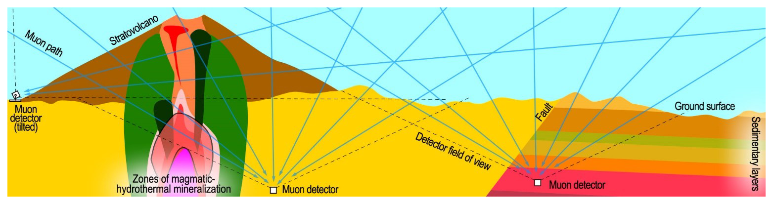
Figure 1A schematic of a complex geological system. The three muographic detectors (white boxes) observe muons originating from a cone-shaped region (bounded by dashed lines) above them. The density profile of any target between the detector and the sky is recorded. Note that the complex porphyry copper deposit model on the left is idealised and not to scale. Typically, the porphyry system spans several vertical kilometres. As muography becomes more time-consuming with depth, imaging the entire porphyry system is challenging. However, erosion, tectonic tilting, and mining may expose different parts of the system, enabling muographic imaging. Image courtesy of Muon Solutions Ltd.
Muography is a statistical imaging method based on astroparticle and high-energy physics with quantum effects. It is thus distinct from the conventional or traditional geophysical methods, e.g., electrical, electromagnetic, seismic, and gravimetric methods, which are all grounded in classical physics. Nevertheless, as each method has its strengths and limitations, combining muography with more conventional methods holds a lot of promise for improvements in geophysical exploration and research. For example, when combined with gravimetric data, muography can enhance the resolution and accuracy of density models (see, for example, Barnoud et al., 2019, and Lechmann et al., 2021, and references therein). Muon data can also be jointly inverted with seismic data (see Oláh et al., 2022, and references therein) as the latter benefits from the density data that are provided by muography.
In the AGEMERA project, muography is applied to three active mines. Each of these sites display different characteristics and unique ore deposit types, providing effective test cases for muography: (1) The underground Lubin Cu-Ag mine in the Fore-Sudetic Monocline district, Poland, offers an excellent testbed for assessing the precision and adaptability of muography in deep underground settings with varying geological conditions, and a novel application. The Lubin ore is a prime example of the Kupferschiefer-type stratabound Cu and Ag deposit and has enrichments of Co, Zn, Ni, Mo, and V. The site also provides an interesting challenge since muography is explicitly applied to study rock mechanics and mining engineering purposes – instead of ore body scanning, where muography is more commonly used; (2) The underground Jajce bauxite mine in Bosnia and Herzegovina is a valuable case study for testing the precision and adaptability of muography in complex geological settings. In principle, the Jajce bauxite deposits can be clearly differentiated from the surroundings. The detectors can be installed directly under the target area, maximising the effectiveness of the density measurements. In most cases, the local bauxite ore has a significant density contrast with the surrounding host limestone (3.05 and 2.7 g cm−3, respectively). However, the limestone has experienced a high level of recent karstification, which complicates the limestone-bauxite boundary zone observation. Understanding the extent and boundaries of the bauxite has direct implications for mining operations, and precise muographic measurements can inform and guide more efficient and environmentally responsible extraction processes; (3) The Assarel open-pit Cu mine in the Apuseni-Banat-Timok-Srednogorie belt in Bulgaria is a good example of a significant porphyry copper deposit. It is locally enriched in platinum group elements (PGEs) and features characteristics of epithermal-style mineralisation. The mine is considerable in size and has well-developed infrastructure, providing ample spatial context for muography while allowing for comprehensive studies over a significant portion of the deposit. The depth and dimensions of the open pit present an ideal case for demonstrating the depth penetration capabilities of muon detection technologies.
3.2 Ambient noise seismic
Conventional seismic methods for georesource exploration rely on active seismic sources, which are renowned for their high-resolution mapping of geological interfaces across a wide range of depths (Gil et al., 2021; Krawczyk et al., 2019; Sheriff and Geldart, 1995). These methods have proved particularly effective for imaging sedimentary basins with horizontal to sub-horizontal stratigraphy, but more recently they have also been successfully applied to characterising complex geological settings for oil, gas, and mineral exploration. Nevertheless, the acquisition of active-source seismic data can be extremely expensive and invasive, requiring access to the survey area with heavy equipment or explosives. Such characteristics make conventional methods unattractive for mining exploration, especially in its early phases. In this context, cost-effective and easy-to-deploy methodologies with low environmental and social impacts are quickly becoming indispensable tools.
Seismic ambient noise is the persistent and ubiquitous seismic wavefield that originates from natural and anthropogenic sources, which are coupled to the solid earth (Diaz et al., 2020; Schimmel et al., 2011; Stutzmann et al., 2009). However, it is only in recent years that ambient noise-based methodologies have been considered as an alternative to active sources, with multiple advantages for shallow subsurface characterisation, encompassing a wide range of applications, from aquifer monitoring to archaeology, glaciology, and mineral exploration (Chamarczuk et al., 2022; Cheraghi et al., 2015; Colombero et al., 2022; Jones et al., 2024).
The Iberian Pyrite Belt (IPB), with its long history of mining activity, hosts not only one of the largest metallogenic provinces worldwide (Leistel et al., 1997) but also multiple areas under environmental protection. Therefore, the deployment of seismic ambient noise-based methodologies in such sensitive environments can help achieve a better balance between the region's rich mining potential and the need to protect its ecology.
For this communication, we introduce the case study of Mina Concepción (Fig. 2a), located in the northeastern sector of the IPB, where we are presently assessing the potential for mineral exploration using three different noise-based imaging approaches: two Ambient Noise Interferometry (ANI) approaches, including tomography and single-station autocorrelation, as well as polarisation analyses. ANI uses synchronous time-correlation of seismic recordings to approximate the Earth's impulse response, that is, its Empirical Green's function (EGF) (Snieder and Wapenaar, 2010). On the other hand, polarisation analysis relies on the evaluation of particle motion, which, in this work depends on the identification of elliptically polarised Rayleigh waves from continuous seismic noise and the subsequent measurement of their ellipticity as a function of frequency (Berbellini et al., 2019). These different imaging methodologies provide independent and complementary observables of the subsurface structure. By integrating these data – using inversion strategies, together with pre-existing geological information (surface mapping and exploration wells) – a comprehensive 3D seismic velocity and structural model of the study area can be constructed.
In 2023, we deployed a portable seismic network of combined short-period (2 Hz) and high frequency (4.5 Hz) sensors over a period of six months at Mina Concepción, with individual deployment durations ranging from 4 to 6 weeks. Interstation distances were kept to a few tens of meters within the more densely studied area of the old open pit mine (5 km2), totalling 114 sites, which provided continuous seismic noise records. Using the aforementioned methodologies, this seismic network aims to image the main geological contacts at depth and thereby to evaluate the potential for mineral exploration while addressing the capabilities and possible limitations posed by the complex geological structure. The application of ANI using autocorrelations provides EGFs, which are a robust approximation of the zero-offset seismic reflection response (primary and multiple reflections) of the structure beneath a seismic station (Romero and Schimmel, 2018). This single-station/single-fold methodology focuses on the analysis of the reflected body waves (P- and S-waves) and their correlation with geological discontinuities beneath each station. At the same time, the extraction and analysis of polarized Rayleigh waves from recorded seismic noise, provides the 1D S-wave profile beneath our seismic stations after inverting the ellipticity measurements for different frequencies. The measured ellipticity only depends on the local structure beneath each site. Furthermore, the deployment of 17 short-period stations over a larger area (∼ 100 km2) enables the application of alternative ANI methodologies, such as cross-correlations between pairs of stations. This will allow the extraction of surface waves, which reveal the 3D S-wave velocity via ambient noise tomography (ANT).
It is noteworthy that these three approaches have typically been employed to investigate regional scales and deep Earth structures, with their joint integration being rare. Therefore, the application of their individual strengths and capabilities to near-surface targets represents a significant innovation. This integration not only enhances the effectiveness of seismic ambient noise methodologies, but also significantly improves mineral exploration efforts. Using non-invasive, cost-effective methods with low social and environmental impacts is essential, especially in ecologically sensitive or densely populated areas. These methods not only enhance our understanding of the subsurface but also offer practical solutions for accessing remote areas, thereby responsibly expanding the scope and efficiency of mineral exploration efforts.
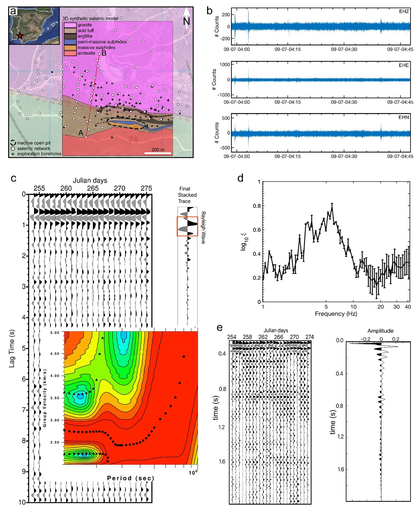
Figure 2(a) Location map of the seismic stations deployed at Mina Concepción (SW Spain) during the 2023 and 2024 campaigns. Basemap layer from ESRI World Imagery compilation (https://services.arcgisonline.com/ArcGIS/rest/services/World_Imagery/MapServer/0, last access: 25 November 2024) edited with QGIS 3.36. (b) Example of a 45 min recording of seismic ambient noise by one of the three-component seismic sensors. (c) Three observables obtained after applying a tomographic approach over a station pair in the study area: (top-left) Record section of their daily cross-correlations, (top-right) stacked cross-correlation function, and (bottom-right) resulting group velocity dispersion curve. (d) Averaged Rayleigh wave ellipticity extracted from polarization analysis performed over several days of seismic ambient noise recordings from one single station. (e) Record section of daily auto-correlation stacks (left panel) and the resulting total autocorrelogram stack (right panel) for one station within the mine.
3.3 Drone-based EM sensing
Geophysical electromagnetic (EM) methods have been used to detect subsurface electrical conductivity (or resistivity) structures for over 100 years (Nabighian, 1991; Zhdanov, 2010). The primary EM field, which is either of natural origin or artificially created, generates currents inside conductive media. These induced currents, in turn, generate secondary EM fields, which alter the amplitude and phase of the measured EM response near the conductive targets. EM methods are utilised, for example, in geological mapping, mineral exploration, groundwater and geotechnical investigations, in addition to environmental monitoring. Airborne EM surveys are highly useful because terrain obstacles can be avoided, and data can be collected more or less evenly and effectively over large areas. Airborne electromagnetic (AEM) surveys become more cost-effective than ground EM surveys if the survey area is sufficiently large (Dentith and Mudge, 2014). The disadvantage is the decrease in data resolution and investigation depth due to the flight height. Another factor that reduces the quality of AEM data is the constant movement of the measurement platform, which shortens the time spent on signal stacking/averaging.
Unoccupied aerial vehicles have now become widely used in magnetic surveys, multispectral imaging, and photogrammetry, in particular. However, drone-based EM applications are still scarce. This is mainly because existing measurement systems cannot be directly installed on drones as the instruments are heavy and/or the flight height weakens the EM response. In the AGEMERA project, the Radai company is developing a totally new lightweight frequency-domain EM system that can be operated with fixed-wing drones. This so-called Louhi system is specifically designed for Nordic conditions where the bedrock is typically resistive, and the sediment/soil layers are thin since ice age glaciation. The Louhi system is designed for quick areal mapping instead of deep and detailed EM exploration. For this reason, the number of frequencies is limited, and the frequencies are rather high (>1000 Hz). In addition, much of the data pre-processing is already done on the hardware level.
Figure 3 illustrates the two operation modes for drone EM surveys. In the semi-airborne mode, which Radai has already successfully implemented, the EM transmitter (Tx) is a large loop (diameter over 100 m) laid on the ground, and the airborne 3-component EM receiver (Rx) is towed by the drone. The surveying is limited to the neighbourhood of the transmitter (distance of less than 2 km), and therefore, this operation mode suits the investigation of known targets. Moreover, accurate data interpretation requires that measurements are repeated using 1–3 alternative transmitter loop locations around the target. In the single-drone configuration, which Radai has been developing in AGEMERA, a small transmitter loop (diameter of about 1 m) is rigidly attached to the same drone that tows the receiver unit. This fully airborne (Slingram) method avoids the need to relocate the ground loop and thus, allows for more efficient mapping of larger areas. The disadvantages are the reduced depth of investigation and the need for a rather long tow line (over 50 m).
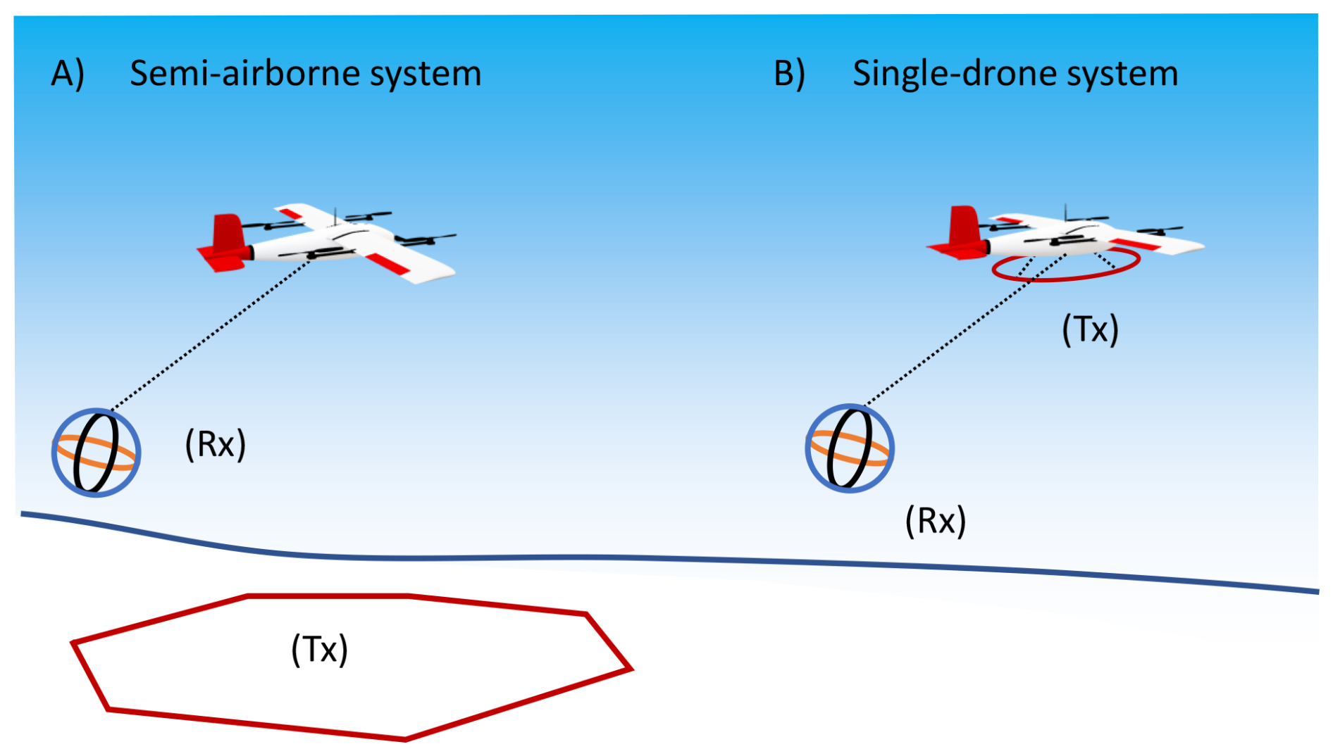
Figure 3Two operation modes for drone-based EM surveys: (a) semi-airborne configuration where the primary EM field is generated by a large transmitter loop (Tx) laid on the ground surface and (b) single-drone system where the drone towing the 3-component receiver (Rx) also carries a small transmitter loop. Image courtesy of Radai Ltd.
Figure 4 shows the 3-component Louhi EM receiver being towed by a VTOL (vertical take-off and landing) drone. The receiver coils are part of the supporting frame of the receiver unit, which is essentially a glider. The flight of the glider is stabilised by an autopilot that controls elevons (tailerons). Based on an in-house calibration method and the drone's inertial measurement unit data, the final processed data are represented as the north, east, and down (NED) components of magnetic flux density (B-field) in femtoteslas (fT). The size and current of the transmitter can vary depending on the target under investigation. Presently, the size of the ground transmitter loop is 100 m by 100 m, and the current is 1–5 A. In the single-drone system, the diameter of the transmitter loop is about 1 m, and the current is 20–30 A. The transmitter electronics unit is small and lightweight, because the same device is used both for the single-drone and semi-airborne system. All three frequencies (2.3, 4.6, 9.2 kHz) are transmitted simultaneously and triggered once per second using a GPS PPS (pulse per second) signal. With minor modifications, it is possible to build a second transmitter-receiver pair that utilises different frequencies for different applications (e.g., geological mapping vs. groundwater studies) and different targets (conductive mineralisations vs. water-filled fractures).
Figure 4 also shows the Coot VTOL drone towing the Louhi EM receiver. The (rotating wing) copter mode allows the receiver to be raised and lowered down safely during take-offs and landings. The (fixed wing) aeroplane mode provides longer flight times than the copter mode. The wingspan of the drone is 2.45 m, and its mass with batteries included is about 12 kg. In semi-airborne surveys, the towline is about 20 m long. For safety reasons, the nominal flight height of the drone is usually 50 m, and the glider is towed 4–7 m lower. The flight speed is about 20 m s−1, and since the sampling rate is 1 s, the spatial data sampling is 10–30 m, depending on the wind direction and intensity. The endurance of a Coot VTOL drone is about 1 h when towing the receiver, which means each survey flight can range up to 70 km. In a single day, a field crew of three people can make 4–6 flights to cover an area of 2 km by 2 km using a 50–75 m line separation and 2–3 different transmitter loop locations. The single-drone system is expected to be at least 50 % more effective.
The VTOL drone is equipped with a 3-component fluxgate magnetometer that is located inside an extended tail-boom of the drone. The static (vector) magnetic field is measured and processed using the methods that Radai uses in their magnetic surveys. The additional information on magnetic field intensity can be very useful in the interpretation of AEM data as the magnetic permeability (or susceptibility) is known to decrease the in-phase component of the frequency-domain EM response. The static magnetic field data can be used jointly in the 1D/3D EM inversion, or the susceptibility distribution obtained from a separate 3D magnetic inversion can be imported into the 3D model and kept fixed in the EM inversion.
Presently, the most challenging task is to develop the numerical tools necessary to quickly process the measured Louhi EM data and to create, for example, maps of apparent conductivity (Pirttijärvi et al., 2014) or multiple 3D model bodies (Pirttijärvi et al., 2002) that reflect the true geoelectrical structure of the subsurface. The accuracy to which the primary field can be determined from Louhi EM data is critical because the primary field is so much stronger than the secondary fields. Only after normalisation or removal of the computed primary field, is it possible to see the effect of secondary fields from any conductivity structures. In practice, 3D numerical modelling and inversion software are required, and development work is going on in cooperation with the Geological Survey of Finland (Xiao et al., 2023).
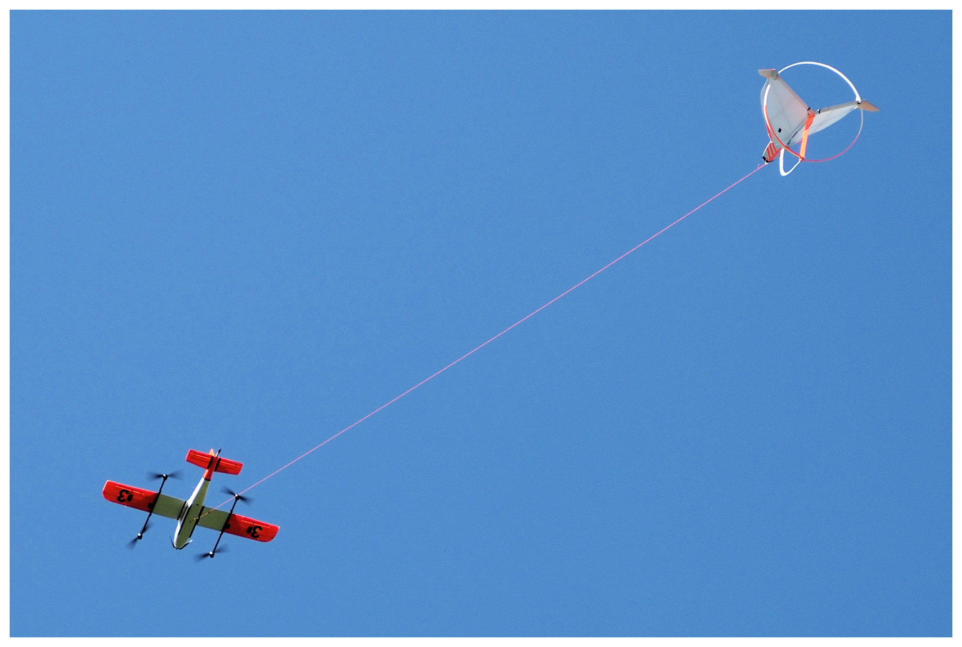
Figure 4The 3-component Louhi EM receiver is being towed by a Coot VTOL drone in the Lintumaansuo EM test survey near Oulu, Finland, in June 2024 (Photo by Markku Pirttijärvi).
The AGEMERA GUI (Graphical User Interface) is a web-based 2D and 3D visualisation platform for geospatial data in Cloud Optimised data formats created by OPT/NET for ease of visualisation and interaction. The overall idea of the AGEMERA GUI is to act as a general repository of geospatial data collected and interpreted during the project. Following recent trends in data visualisation, it allows for so-called “geospatial storytelling” – equally effective with experts and untrained users.
Using web services compliant with Open Geospatial Consortium (OGC) standards, the AGEMERA GUI gathers both derivatives of open satellite data (both optical and SAR) and complex visualisations of innovative geophysical methods described in this article for all projects' field trials. It offers fast, clear, and straightforward mechanisms for the interactive exploration of datasets, catering both to the general public (satellite data) and specific stakeholders (geophysical data). Additionally, the platform is built with the future in mind, open to evolving to meet emerging needs, including data security through various levels of authentication and authorisation, thereby ensuring data integrity.
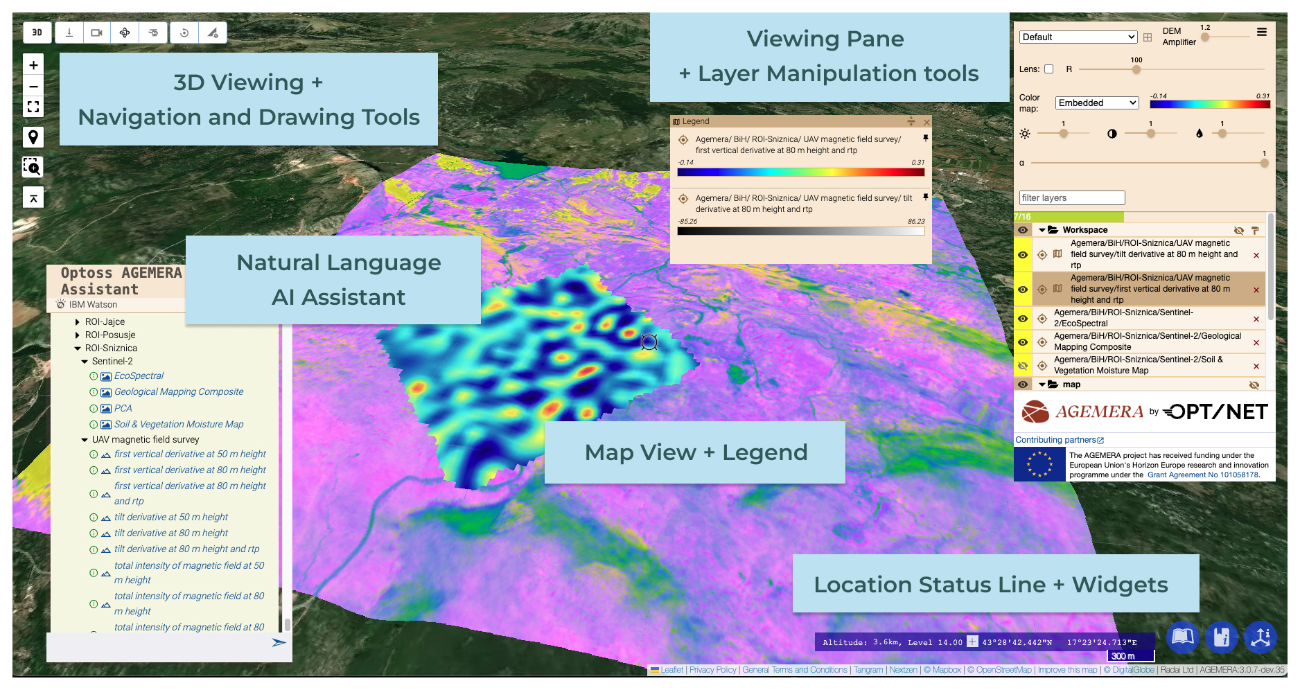
Figure 5Main Features of the AGEMERA GUI. Picture by OPT/NET.
A distinctive feature of the platform is its conversational AI natural language processor (NLP) based on large language models (LLM), which simplifies navigating through the extensive data. This feature, currently only available in English, addresses the challenge of interacting with large geospatial datasets moving beyond traditional computer interfaces to offer a more natural and engaging user interaction.
The platform also incorporates the OGC Web Map Service (WMS) standards, enabling the visualisation of map stacks. This feature not only enriches data interpretation but also ensures interoperability with existing geospatial systems, fostering enhanced data sharing and collaboration within the geoscience community. The AGEMERA GUI also has the capability of interacting with layers of up to 16 layers of GIS information from different sources with accompanying extrusion maps (so-called 2.5D extrusion of the surface) at the same time. The main features of the AGEMERA GUI are shown in Fig. 5.:
-
Map View
-
Natural language AI Assistant
-
Navigation and drawing tools
-
3D viewing mode (terrain extrusion with accompanying DEM and switching between Globe view or Flat map view) with the camera positioning tool
-
Location status-line with information about the current zoom level, approximate viewing height, map scale, and geographic coordinates (latitude, longitude) under the cursor
-
Viewing panel tools (adjustment of brightness, contrast, opacity, and transparency, changing embedded colour map and base layer thematic maps, and the “lens-” and “multi-lens-” combo and DEM amplifier tool)
To safeguard proprietary data and to control access effectively, the AGEMERA platform implements a robust data access control mechanism. Currently, two distinct user groups are established: the general public and consortium members. The general public is granted access to open data sources, including Sentinel-1, Sentinel-2, ASTER, and their derivatives. In contrast, consortium members have broader access privileges, allowing for the visualisation of all published datasets on the platform. Furthermore, data owners and providers maintain control over their dataset's visibility, deciding whether to make them accessible to the general public or to restrict access to consortium members only. This flexibility ensures that data owners can manage and protect their proprietary information effectively while leveraging the AGEMERA platform for visualisation and dissemination purposes.
The AGEMERA project effectively advances the European Union's strategic goals set by the European Critical Raw Materials Act (CRMA), which is aimed at securing a sustainable and autonomous supply chain for critical raw materials that re essential for the EU's green and digital transitions. The project successfully integrates innovative, non-invasive geophysical methodologies and mineral exploration methods to reduce Europe's dependence on imported materials and to enhance supply chain resilience.
Throughout the project, advanced geophysical methods such as muography, passive ambient noise seismology, and drone-based electromagnetic sensing have been deployed. These methods have significantly improved the accuracy of subsurface assessments while minimising environmental impacts, aligning with the EU's sustainability objectives. The natural language based AGEMERA GUI integrates different data sources for improved data access and visualisation in 3D. Given the growing global emphasis on resource security influenced by environmental and geopolitical factors, the methodologies refined and developed through AGEMERA are expected to influence future exploration practices worldwide.
No data sets were used in this article.
JJ: conceptualisation, writing original draft preparation, review and editing, project administration; MH: contributing to Sect. 2, writing Sect. 3.1, review and editing; PK and JK: writing Sect. 3.1, review and editing; HS, DML, MS, GC and GGB: writing and visualising Sect. 3.2., review and editing; MP and AS: writing Sect. 3.3, review and editing; BŠT and IK: writing Sect. 4, review and editing.
The contact author has declared that none of the authors has any competing interests.
Publisher's note: Copernicus Publications remains neutral with regard to jurisdictional claims made in the text, published maps, institutional affiliations, or any other geographical representation in this paper. While Copernicus Publications makes every effort to include appropriate place names, the final responsibility lies with the authors.
This article is part of the special issue “European Geosciences Union General Assembly 2024, EGU Division Energy, Resources & Environment (ERE)”. It is a result of the EGU General Assembly 2024, Vienna, Austria, 14–19 April 2024.
This research has been supported by the HORIZON EUROPE Digital, Industry and Space (grant no. 101058178).
This paper was edited by Giorgia Stasi and reviewed by Longying Xiao and one anonymous referee.
Barnoud, A., Cayol, V., Niess, V., Cârloganu, C., Lelièvre, P., Labazuy, P., and Le Ménédeu, E.: Bayesian joint muographic and gravimetric inversion applied to volcanoes, Geophys. J. Int., 218, 2179–2194, https://doi.org/10.1093/GJI/GGZ300, 2019.
Beni, T., Borselli, D., Bonechi, L., Bongi, M., Brocchini, D., Ciaranfi, R., Cimmino, L., Ciulli, V., D'Alessandro, R., Dini, A., Frosin, C., Gigli, G., Gonzi, S., Guideri, S., Lombardi, L., Nocentini, M., Saracino, G., and Casagli, N.: Transmission-Based Muography for Ore Bodies Prospecting: A Case Study from a Skarn Complex in Italy, Nat. Resour. Res., 32, 1529–1547, https://doi.org/10.1007/s11053-023-10201-8, 2023.
Berbellini, A., Schimmel, M., Ferreira, A. M. G., and Morelli, A.: Constraining S-wave velocity using Rayleigh wave ellipticity from polarization analysis of seismic noise, Geophys. J. Int., 216, 1817–1830, 2019.
Chamarczuk, M., Malinowski, M., Draganov, D., Koivisto, E., Heinonen, S., and Rötsä, S.: Reflection imaging of complex geology in a crystalline environment using virtual-source seismology: case study from the Kylylahti polymetallic mine, Finland, Solid Earth, 13, 705–723, https://doi.org/10.5194/se-13-705-2022, 2022.
Cheraghi, S., Craven, J. A., and Bellefleur, G.: Feasibility of virtual source reflection seismology using interferometry for mineral exploration: A test study in the Lalor Lake volcanogenic massive sulphide mining area, Manitoba, Canada, Geophys. Prospect., 63, 833–848, 2015.
Colombero, C., Papadopoulou, M., Kauti, T., Skyttä, P., Koivisto, E., Savolainen, M., and Socco, L. V.: Surface-wave tomography for mineral exploration: a successful combination of passive and active data (Siilinjärvi phosphorus mine, Finland), Solid Earth, 13, 417–429, https://doi.org/10.5194/se-13-417-2022, 2022.
Dentith, M. and Mudge, S. T.: Geophysics for the Mineral Exploration Geoscientist, Cambridge University Press, https://doi.org/10.1017/CBO9781139024358, 2014.
Diaz, J., Schimmel, M., Ruiz, M., and Carbonell, R.: Seismometers Within Cities: A Tool to Connect Earth Sciences and Society, Front. Earth Sci. (Lausanne), 8, https://doi.org/10.3389/feart.2020.00009, 2020.
European Commission: Proposal for a REGULATION OF THE EUROPEAN PARLIAMENT AND OF THE COUNCIL establishing a framework for ensuring a secure and sustainable supply of critical raw materials and amending Regulations, https://doi.org/10.2760/386650, 2023.
European Commission: Regulation (EU) 2024/1252 of the European Parliament and of the Council of 11 April 2024 establishing a framework for ensuring a secure and sustainable supply of critical raw materials and amending Regulations (EU) No 168/2013, (EU) 2018/858, (EU) 2018/1724 and (EU) 2019/1020Text with EEA relevance, 2024.
Gil, A., Malehmir, A., Buske, S., Alcalde, J., Ayarza, P., Martínez, Y., Lindskog, L., Spicer, B., Carbonell, R., Orlowsky, D., Carriedo, J., and Hagerud, A.: Reflection seismic imaging to unravel subsurface geological structures of the Zinkgruvan mining area, central Sweden, Ore Geol. Rev., 137, 104306, https://doi.org/10.1016/j.oregeorev.2021.104306, 2021.
Hivert, F., Roche, I. L., Decitre, J. B., Brunner, J., Busto, J., and Gaffet, S.: Muography sensitivity to hydrogeological rock density perturbation: Roles of the absorption and scattering on the muon flux measurement reliability, Near Surf. Geophys., 15, 121–129, https://doi.org/10.3997/1873-0604.2016053, 2017.
Holma, M., Korteniemi, J., Casini, G., Saura, E., Šumanovac, F., Kapuralić, J., and Tornos, F.: Agile exploration and geo-modelling for European critical raw materials: introduction to the AGEMERA project, in: Lithosphere 2022 Twelfth Symposium On The Structure, Composition And Evolution Of The Lithosphere, 51–54, 2022.
Holma, M., Peytcheva, I., Šumanovac, F., Tornos, F., Nyambe, I., and Joutsenvaara, J.: Horizon Europe project AGEMERA: Combining novel methodologies for agile exploration and geomodelling of critical raw materials deposits, in: Proceedings of the Geological Society of Finland, vol. 3, Suomen Geologinen Seura, Helsinki, 43, 2023.
Jones, T., Olivier, G., Murphy, B., Cole, L., Went, C., Olsen, S., Smith, N., Gal, M., North, B., and Burrows, D.: Real-Time Ambient Seismic Noise Tomography of the Hillside Iron Oxide–Copper–Gold Deposit, Minerals, 14, 254, 2024.
Krawczyk, C. M., Stiller, M., Bauer, K., Norden, B., Henninges, J., Ivanova, A., and Huenges, E.: 3-D seismic exploration across the deep geothermal research platform Groß Schönebeck north of Berlin/Germany, Geoth. Energ., 7, 15, https://doi.org/10.1186/s40517-019-0131-x, 2019.
Lechmann, A., Mair, D., Ariga, A., Ariga, T., Ereditato, A., Nishiyama, R., Pistillo, C., Scampoli, P., Schlunegger, F., and Vladymyrov, M.: Muon tomography in geoscientific research – A guide to best practice, Earth Sci. Rev., 222, https://doi.org/10.1016/j.earscirev.2021.103842, 2021.
Leistel, J. M., Marcoux, E., Thiéblemont, D., Quesada, C., Sánchez, A., Almodóvar, G. R., Pascual, E., and Saez, R.: The volcanic-hosted massive sulphide deposits of the Iberian Pyrite Belt Review and preface to the Thematic Issue: Review and preface to the Thematic Issue, Miner. Depos., 33, 2–30, 1997.
Lowrie, W. and Fichtner, A.: Fundamentals of Geophysics, 3rd edn., Cambridge University Press, https://doi.org/10.1017/9781108685917, 2020.
Malmqvist, L., Jönsson, G., and Kristiansson, K.: In situ density determination by means of underground cosmic-ray intensity measurements a theoretical study, Geoexploration, 16, 318, 1978.
Malmqvist, L., Jonsson, G., Kristiansson, K., and Jacobsson, L.: Theoretical studies in in-situ rock density determinations using underground cosmic-ray muon intensity measurements with application in mining geophysics, Geophysics, 44, 1549–1569, https://doi.org/10.1190/1.1441026, 1979.
Nabighian, M. N. (Ed.): Electromagnetic Methods in AppliedGeophysics, vol. 2, Application, Parts A and B, SEG, Tulsa, https://doi.org/10.1190/1.9781560802686, 1991.
Oláh, L., Tanaka, H. K. M., Hamar, G., and Varga, D.: Investigation of the limits of high-definition muography for observation of Mt Sakurajima, Philos. T. Roy. Soc. A, 377, 2137, https://doi.org/10.1098/rsta.2018.0135, 2019.
Oláh, L., Tanaka, H. K. M., and Varga, D. (Eds.): Muography: Exploring Earth's Subsurface with Elementary Particles, American Geophysical Union and John Wiley & Sons, https://doi.org/10.1002/9781119722748, 2022.
Pirttijärvi, M., Pietilä, R., Hattula, A., and Hjelt, S.-E.: Modelling and inversion of electromagnetic data using an approximate plate model, Geophys. Prospect, 50, 425–440, 2002.
Pirttijärvi, M., Zaher, M. A., and Korja, T.: Combined Inversion of Airborne Electromagnetic and Static Magnetic Field Data, Geophysica, 50, 2014.
Romero, P. and Schimmel, M.: Mapping the basement of the Ebro Basin in Spain with seismic ambient noise autocorrelations, J. Geophys. Res.-Sol. Ea., 123, 5052–5067, 2018.
Schimmel, M., Stutzmann, E., Ardhuin, F., and Gallart, J.: Polarized Earth’s ambient microseismic noise, Geochem. Geophys. Geosyst., 12, https://doi.org/10.1029/2011GC003661, 2011.
Sheriff, R. E. and Geldart, L. P.: Exploration Seismology, Cambridge University Press, https://doi.org/10.1017/CBO9781139168359, 1995.
Snieder, R. and Wapenaar, K.: Imaging with ambient noise, Phys. Today, 63, 44–49, 2010.
Stutzmann, E., Schimmel, M., Patau, G., and Maggi, A.: Global climate imprint on seismic noise, Geochem. Geophys. Geosyst., 10, https://doi.org/10.1029/2009GC002619, 2009.
Xiao, L., Patzer, C., and Kamm, J.: 3D inversion of drone electromagnetic data–the DroneSOM project, in: XXVIII General Assembly of the International Union of Geodesy and Geophysics (IUGG), 11–20 July 2023, Berlin, 2023.
Zhdanov, M. S.: Electromagnetic geophysics: Notes from the past and the road ahead, Geophysics, 75, 75A49–75A66, 2010.
- Abstract
- Introduction
- Geophysical methods as part of the geoscientific toolbox for mineral exploration
- The Innovative Non-Invasive Geophysical Methodologies for Mineral Exploration
- AGEMERA GUI
- Conclusions
- Data availability
- Author contributions
- Competing interests
- Disclaimer
- Special issue statement
- Financial support
- Review statement
- References