 | 26 Jun 2024
The Neapolitan Yellow Tuff record in the Gaeta Gulf (Eastern Tyrrhenian margin, Southern Italy)
Agostino Meo
Gemma Aiello
Maria Rosaria Senatore
The Neapolitan Yellow Tuff caldera-forming eruption (ca. 15 kyr) is a large event that occurred at Phlegrean Fields during the Late Glacial–Holocene time span. The eruptive products represent a widespread isochronous marker that links the marine and terrestrial stratigraphic record of the central Mediterranean and Northern Europe sequences. In this research, we describe the stratigraphic signature of the NYT deposits in the Late Glacial–Holocene shelf sequence of the Gulf of Gaeta (northern Campania region, southern Tyrrhenian Sea) throughout the seismo-stratigraphic interpretation of a grid of high and very high-resolution Chirp seismic profiles. The seismo-stratigraphic data allowed to individuate in the Upper Pleistocene–Holocene stratigraphic architecture a continental shelf characterized by an offlap prograding succession followed by a very thick transgressive onlapping unit, and by an upper highstand unit mainly characterized by undulations probably linked to gas-prone sediment. The NYT reflector observed was parallel and with a high amplitude. It was continuously detected from the shelf to the slope within transgressive deposits. On the inner shelf, its continuity was interrupted by shallow gas pockets. The NYT depths ranges from 2 m b.s.f. on the slope to 38 m b.s.f. on the continental shelf. The NYT event appeared to have played a key role in controlling the stratigraphic architecture of the studied area during the last transgression, acting as a trigger for the formation of the aggradational sedimentary successions fed by pyroclastic and volcaniclastic deposits.
- Article
(9706 KB) - Full-text XML
- BibTeX
- EndNote


The eruption of Neapolitan Yellow Tuff (NYT), which resulted in the formation of a caldera at 14.9±0.4 kyr BP (Deino et al., 2004), was a significant event that occurred at Phlegrean Fields (PF) during the Late Glacial–Holocene (e.g. Rolandi et al., 2020; Orsi, 2022, and references therein). Its eruptive materials, together with the eruptive products of the Campanian Ignimbrite (CI), represent widespread isochronous markers that link marine and terrestrial record of the central Mediterranean area and Northern Europe sequences (Schmidt et al., 2002; Giaccio et al., 2008; Smith et al., 2011; Insinga et al., 2014; Morabito et al., 2014; Rolandi et al., 2020; Tomlinson et al., 2022; Sawyer et al., 2023, among others). In particular, the NYT has been correlated to the Late Glacial marker tephra C-2 (Paterne et al., 1988), recorded in the Central Mediterranean (Bourne et al., 2010; Totaro et al., 2022, and reference therein). The sea occurrence of the NYT deposits in the studied area (Gulf of Gaeta, northern Campania region, southern Tyrrhenian Sea) was recognized, for the first time, intercalated in the post-glacial deposits, in the southern sector of the Gaeta Gulf, by Iorio et al. (2014), whereas its geochemical characteristics and its extension were later reconstructed by Aiello et al. (2017). The aim of this study is to further characterize the NYT as an isochronous marker, extending, through a grid of 15 high and extremely high-resolution seismic lines calibrated with gravity cores, the knowledge of its seismo-stratigraphic architecture in the Late Glacial–Holocene shelf sequence of the whole Gulf of Gaeta, and providing also new maps of the thickness and depth of the NYT deposits.
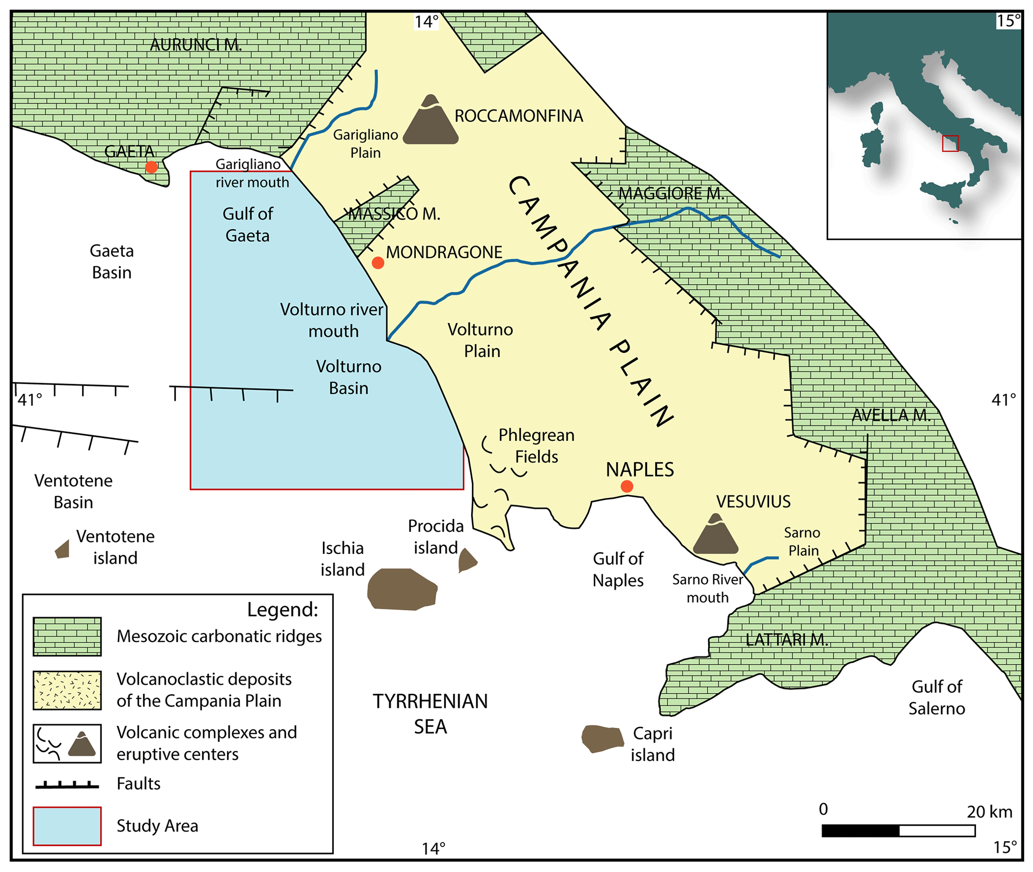
Figure 1Sketch geological map of the Campania Plain and study area. Legend as in figure.
The Gulf of Gaeta represents the northern Campania continental margin that is part of a large extensional Plio-Pleistocene basin associated with NW-SE trending normal faults and lateral strike-slip faults linked to the evolution of the eastern Tyrrhenian Sea margin (Fig. 1). Since mid-late Pleistocene, extensional tectonics in the region, was accompanied by the onset of an intense volcanic activity, originating, among others, the volcanic area of the PF, which has greatly influenced the sedimentation in this sector. During the Plio-Quaternary, the northern Campania continental margin was marked by the development of marine regions, such as the Gaeta basin, experiencing subsidence responsible for thick sedimentary deposits (Trincardi and Zitellini, 1987; Bartole et al., 1983; Sartori et al., 2004; Aiello et al., 2011; Torrente and Milia, 2013; Conti et al., 2017; Aiello and Cicchella, 2019). The sedimentary filling in the Gaeta basin comprises alternating clastic marine and continental deposits (Amore et al., 2000; Aiello et al., 2000, 2011; Amorosi et al., 2012; Iorio et al., 2014; Margaritelli et al., 2016; Aiello, 2017; Misuraca et al., 2018), along with volcanic deposits mostly provided by the close volcanic district of the PF, which has been active for the past 50 kyr (De Vivo et al., 2020; Orsi, 2022). The Quaternary marine and continental succession of the Gaeta coastal plains is very thick, and characterized by aggradational and progradational units, interpreted as deltaic deposits organized in transgressive-regressive facies cycles. Moreover, the Gaeta extensional basin, delimited at east by NW-SE-trending normal faults, from north to south shows E-W-trending normal and right strike-slip faults which displaced, both the Quaternary deposits and the Meso-Cenozoic acoustic basement (Ortolani and Aprile, 1978; Aiello et al., 2000). In addition, two depocentral areas (coincident with the Garigliano and Volturno deltas) are present in Gaeta basin, of these two areas the structural asset of the second is known as an half-graben by means of seismo-stratigraphic analysis, affecting the top of the Miocene acoustic basement (Aiello et al., 2011; Misuraca et al., 2018). Since the Late Pleistocene overwhelming volcanism has marked the Campania Plain and generated volcanic deposits, mainly due to the eruptions of the CI (about 40 kyr, e.g. Silleni et al., 2020, and references therein) and of the NYT (about 15 kyr e.g. Deino et al., 2004, and references therein). The present morphological depression of the PF primarily derives from the younger NYT caldera collapse, partially masking the preexisting PF caldera (e.g. Orsi, 2022, and reference therein). The NYT, composed of rocks ranging from latites to alkali-trachytes, was deposited in two members, characterized by different texture, dispersal pattern, and magmatic composition. The tuff crops out over an area of 1000 km2 (e.g. Acocella, 2008; Sacchi et al., 2014; Aiello et al., 2020; Corradino et al., 2021; Aiello and Caccavale, 2023a; Orsi, 2022, and references therein).
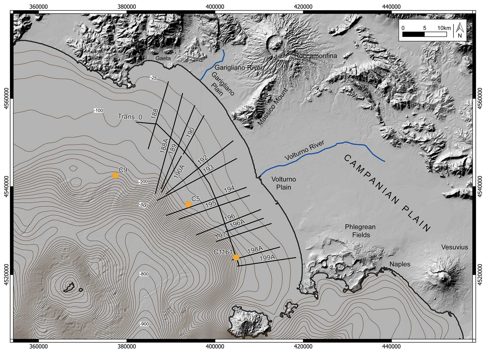
Figure 2Location map of 15 Chirp seismic profiles with superimposed location of the C5 (Misuraca et al., 2018), C9 (Amore et al., 2000), and C1161 (Iorio et al., 2014; Aiello et al., 2017) cores, used in the stratigraphic calibration of the NYT (V) reflector.
A seismo-stratigraphical analysis was performed carrying out 15 Sub-bottom Chirp profiles. These latter were collected in the frame of research projects on marine geological mapping on the continental shelf offshore of the Campania region (Oceanografic Cruise, CARG Project, 2003). The instrument used was a Sub-bottom Chirp profiler (Datasonics Inc.), in dotation to the R/V Urania (CNR). An average velocity of 1550 m s−1 for time-to-depth conversion was used. Penetration was between 25 and 50 m below the sea bottom. Positioning was established through the Starfix differential GPS. The location of seismic profiles and gravity cores was reported in Fig. 2. The obtained seismo-stratigraphic results were integrated with previous stratigraphic results on the same dataset and with previous tephrostratigraphic data from core samples (Iorio et al., 2014; Aiello et al., 2017). The seismo-stratigraphic analysis is based on the designation of the discontinuities and, consequently, of the depositional sequences, fixing the original geometry of the sedimentary bodies and related sedimentary environments, and chronostratigraphic correlation. High-resolution seismic and sequence stratigraphy has been described in detail as a valuable technique of analysis of seismic profiles (Van Wagoner et al., 1988, and references therein; Catuneanu et al., 2009; Zecchin and Catuneanu, 2013; Catuneanu, 2019; Zecchin et al., 2019) and has been herein applied in the geological interpretation of the collected seismic profiles, where geometry, discontinuities related to important stratigraphic gaps, and chronostratigraphic surfaces of the seismic reflectors have allowed us to divide them into systems tract. Subsequently, the systems tract and their bounding surfaces have been discussed (e.g. Zecchin and Catuneanu, 2013), and classified as sequence stratigraphic frameworks because they describe the time and size of the parts that make up the basin. The HIS Kingdom® software was used for the processing, management and interpretation of the seismic lines. So far gridding and contouring have been carried out on the NYT seismic horizon in order to generate the isochronous map of the NYT in the whole Gaeta Gulf.
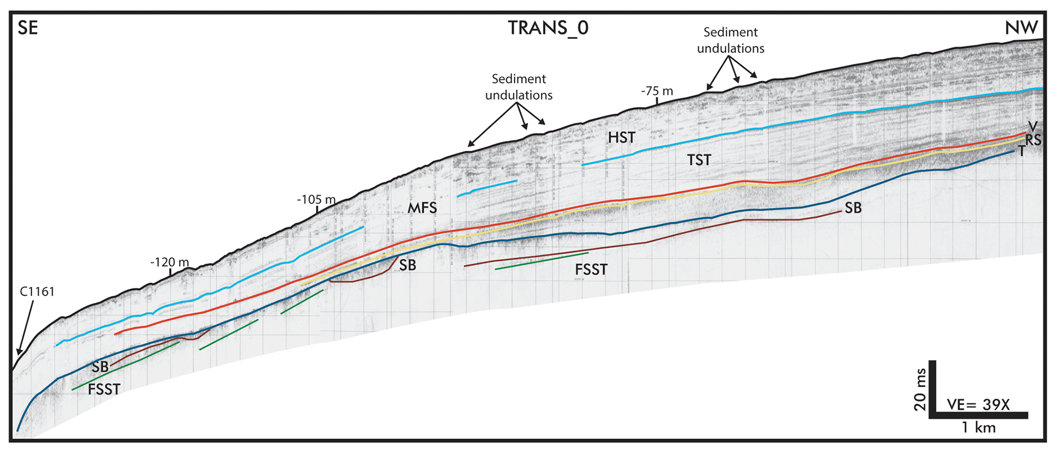
Figure 3Sub-bottom Chirp profile Trans_0 and corresponding geological interpretation, showing the Late Pleistocene–Holocene stratigraphic architecture of the continental shelf (reinterpreted after Iorio et al., 2014).
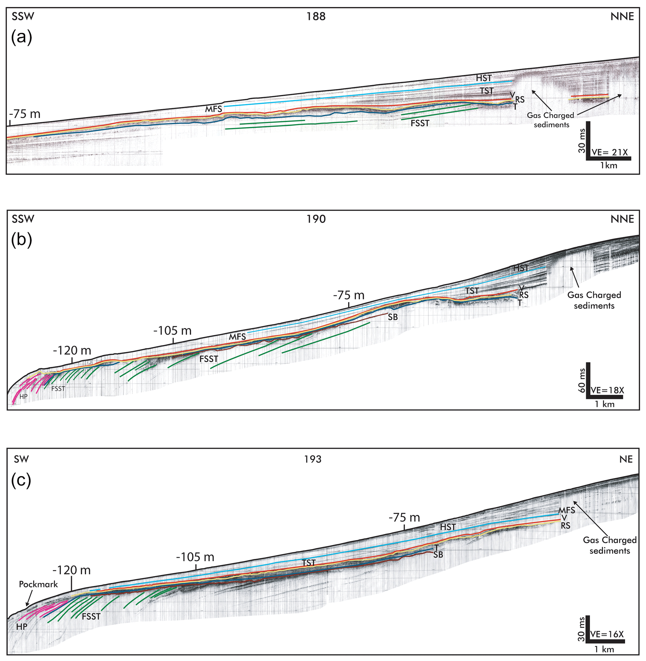
Figure 4Northern and central sector of the Gulf of Gaeta (a) Sub-bottom Chirp profile 188 and corresponding geological interpretation; (b) Sub-bottom Chirp profile 190 and corresponding geological interpretation; (c) Sub-bottom Chirp profile 193 and corresponding geological interpretation.
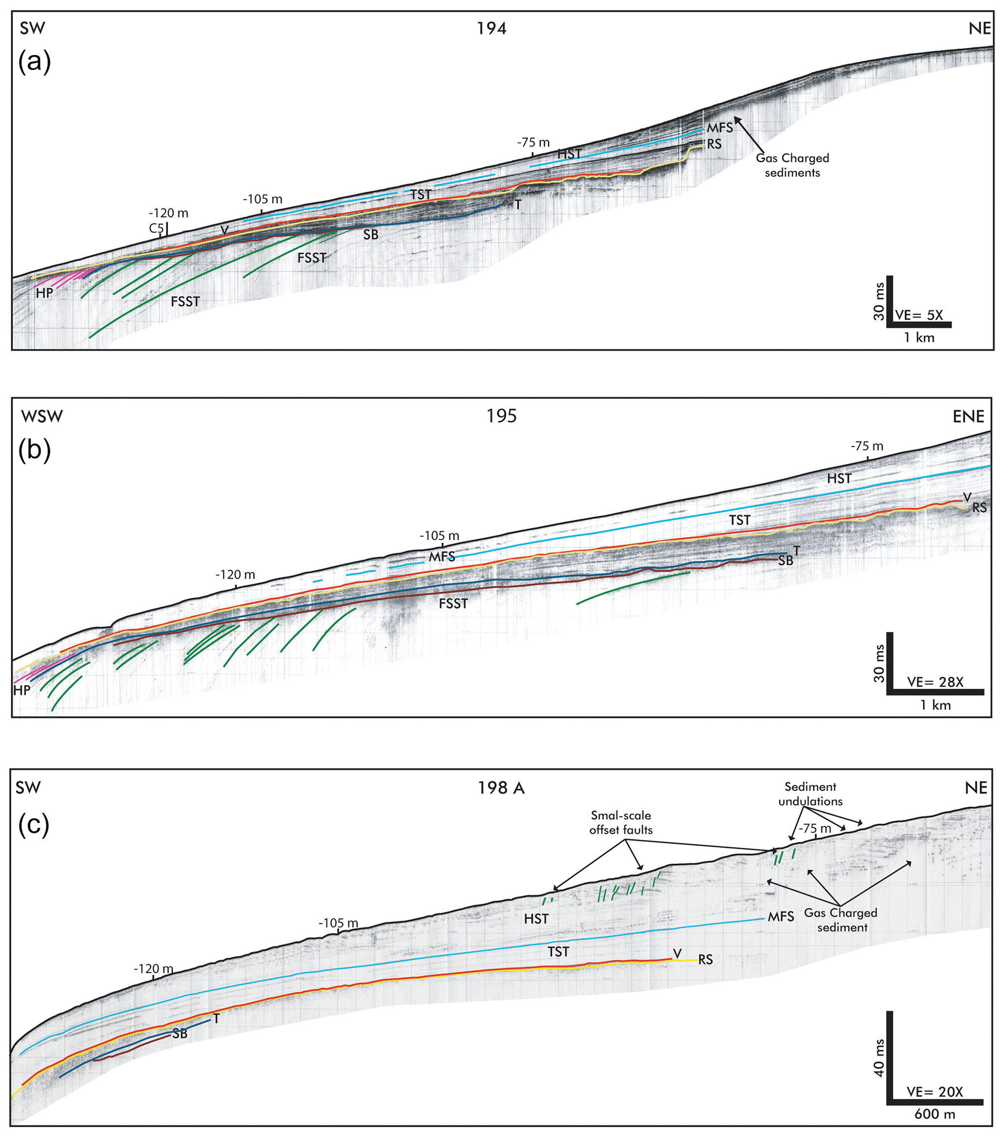
Figure 5Central and southern sectors of the Gulf of Gaeta (a) Sub-bottom Chirp profile 194 and corresponding geological interpretation. (b) Sub-bottom Chirp profile 195 and corresponding geological interpretation. (c) Sub-bottom Chirp profile 198A and corresponding geological interpretation (reinterpreted after Iorio et al., 2014).
4.1 The Late Pleistocene–Holocene stratigraphic architecture of the northern Gaeta Gulf continental shelf
A detailed analysis of the stratigraphic architecture of the Gulf of Gaeta was conducted in order to identify the seismic horizon representative of the NYT. Starting from the bottom, the base unit was identified. It represents the Falling Stage Systems Tract (FSST) and comprises seismic horizons with moderate amplitude and continuity. These reflectors are in offlap (progradational phase) towards the southwest, with a gradient of approximately 1°. In some cases, the continental sequence boundary (SB) breaks up the upper part of the offlap reflections. The FSST is limited upwards by a transgressive surface of erosion (TS), displayed on the seismic sections by a well-marked horizon deepening towards the sea (Figs. 3, 4 and 5). The Transgressive Systems Tract, (TST), in onlap on the TS surface, includes the Healing Phase unit (HP; Posamentier, 1993) which is characterized by sediments deposited within the deepest area occurring seawards of the last clinoforms of the underlying progradational phase (Posamentier and Allen, 1993). Furthermore, towards the coast, on the TS surface, depositional back stepping sediment bodies occur characterized by lenticular shape. They are gradually more recent towards the coast and are made up internally by downlap clinoforms laying on the base surface, while at the top they are truncated by the erosion ravinement surface (RS). On top of RS, a conformable reflector (V) characterized by high continuity and amplitude is continuously detected on the shelf and upper slope of the entire Gaeta Gulf. The upper TST is marked by parallel and continuous seismic horizons with a low amplitude (Figs. 3, 4 and 5) and its upper boundary corresponds to the Maximum Flooding Surface (MFS). The RS is typically taken as the key surface that separates the “lower TST” (below) from the “upper TST” (above). In this respect, the NYT would occur near the base of the upper TST. Above the MFS, there is the youngest seismic unit, which represents the Highstand Systems Tract (HST), whose thickness decreases towards the shelf break (Figs. 4 and 5). On the seismic profiles located in the southern part of the shelf, both the TST and HST display a high thickness. However, the high thickness of this seismo-stratigraphic unit, on the seismic profile 198A (Fig. 5c), shows small holes in the ground reflecting sound waves. The sound waves can be moderate to strong, and locally they are caused by small pockets of gas that cover up the sound. The undulated reflections in the upper HST are found at water depths ranging between 70 and 120 m, where the slope gets steeper. The undulated reflectors allow to distinguish individual reflections packets based on small-scale, differently oriented, extensional offset faults (Fig. 5c, Iorio et al., 2014). The individual reflections packets exhibit internal slightly counter-slope dipping, an asymmetrical distribution, and a steeper down-slope flank. Furthermore, they are distinguished by a constant amplitude.
4.2 The V reflector in the northern shelf of Gaeta Gulf
On the northern shelf of the Gaeta Gulf, the seismo-stratigraphic analysis has allowed us to identify a highly continuous seismic reflector (V), intercalated in the lower part of the TST, which is only locally interrupted by shallow gas pockets (Fig. 4). Moreover, the same V reflector has been detected continuously from the shelf to the slope in the southern part of the Gaeta Gulf, within the transgressive deposits, displaying parallel and a high amplitude trend. (Figs. 3 and 5). So far the V reflector represents a widespread marker across the entire continental shelf of the Gulf of Gaeta. Proceeding from the shelf to the basin, in the northern sector the V reflector defines a surface regularly dipping towards the south-west, at a depth measured from the sea level between 80 and 170 m and with the thickness of sediments between the seafloor and V, which ranges between 8 and 28 m (Figs. 6 and 7), while at the mouth of the Garigliano River this thickness attains 18 m. In the southern shelf of the Gaeta Gulf, the thickness of the sediments between the sea floor and this surface ranges between 28 and 38 m, while the surface trending is comparable with the northern V surface, and it is similar to the V reflector trending previously identified by Aiello et al. (2017). The seismic profiles interpreted in both sectors of the gulf show that the greatest thickness of sediments above V is found at the mouth of the Volturno River.

Figure 6Map of the depth trend of the V reflector, interpreted as Neapolitan Yellow tuff (NYT) deposits from the sea level (modified after Aiello et al., 2017). The colorimetric scale represents the variation of the depth in milliseconds with the corresponding values in meters.
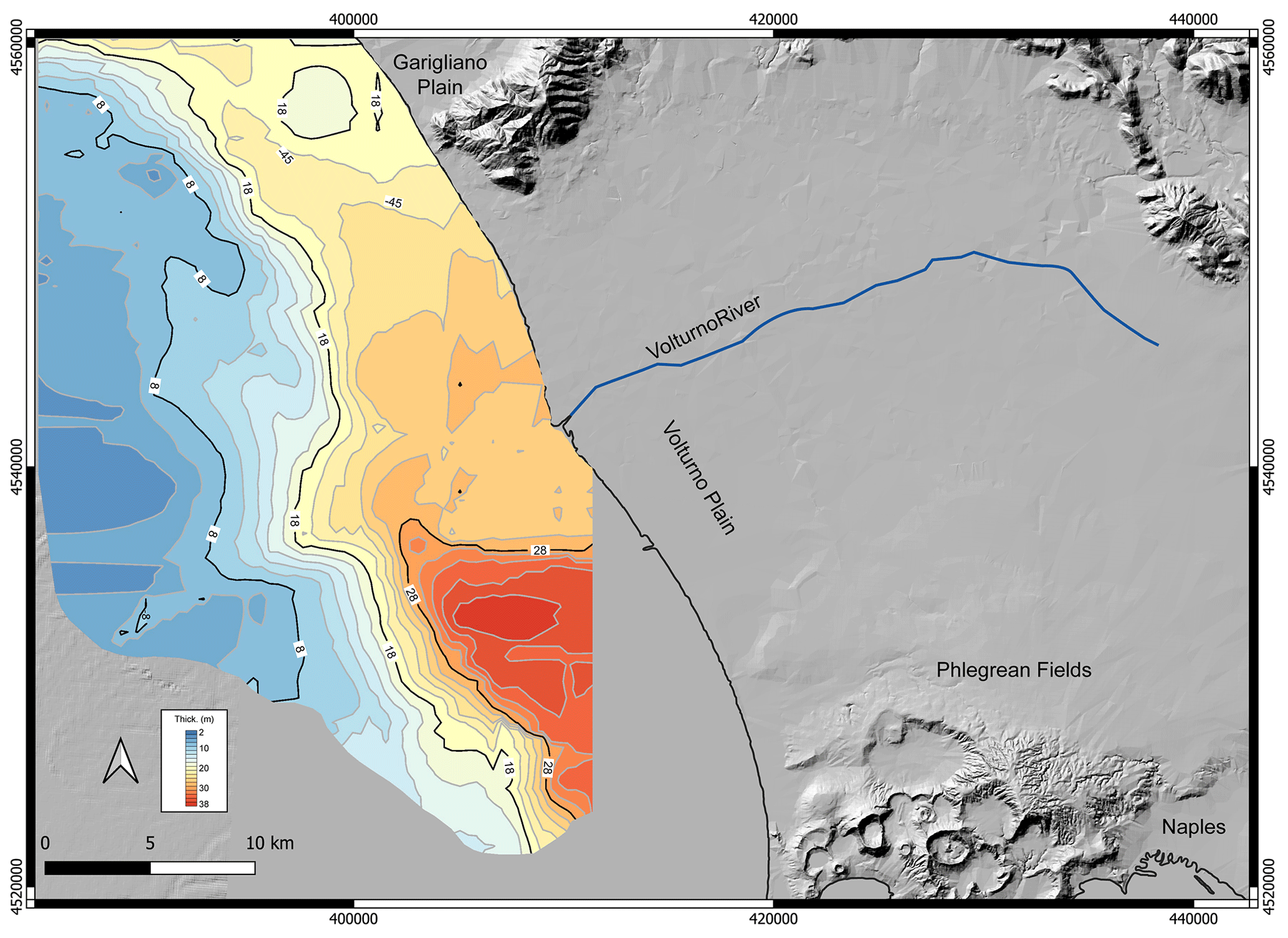
Figure 7Isopach map from sea level of the Holocene sediments overlying the Neapolitan Yellow Tuff (NYT) deposits (this paper).
5.1 The stratigraphy of the Gulf of Gaeta continental shelf
The seismic profiles previously published by Iorio et al. (2014) and Aiello et al. (2017), have been reassessed and, together with those located in the northern sector, have been interpreted in order to show the Late Pleistocene–Holocene stratigraphy of the continental shelf of the Gaeta Gulf (Figs. 3, 4 and 5). The Late Pleistocene–Holocene stratigraphy of the continental shelf is characterized by an offlap prograding succession, followed by a very thick transgressive onlapping unit and by an upper highstand unit, which is mainly characterized by undulations probably linked to gas-prone sediment (Figs. 3, 4 and 5). The seismo-stratigraphic analysis, carried out based on Tyrrhenian regional geology (Trincardi and Field, 1991; Aiello et al., 2000, 2011; Buccheri et al., 2002; Sartori et al., 2004; Iorio et al., 2014; Aiello et al., 2017; Conti et al., 2017; Misuraca et al., 2018; Milia and Torrente, 2020; Frezza et al., 2021; Loreto et al., 2021; Torrente et al., 2023; Aiello and Caccavale, 2023a, b), has highlighted the stratigraphy of the study area. The inner sequence boundary, namely SB, has been recognized, eroding the clinoforms of the FSST seismo-stratigraphic unit. It testifies to an erosional phase occurring during the shelf progradation of the Last Glacial Maximum (LGM). Similar sequence boundaries have been recognized in the stratigraphic architecture of the Mediterranean continental margins (Lykousis et al., 2005; Bassetti et al., 2008; Ridente, 2018; Aiello, 2023, among others), punctuating the inner stratigraphy of the lowstand prograding wedges. The progradational seismic facies of the FSST deposits (Figs. 3, 4 and 5) let us interpreting them as deposited during the LGM Sea level fall that lasted up to about 18 kyr BP. The HP wedge unit is composed of the sediments derived by transgressive erosion of the substratum transported seawards of FFST and is deposited as a healing phase and progressively infills or “heals over” to rebalance the longitudinal gradient until that equilibrium profile is re-established (Posamentier and Allen, 1993). The RS (Figs. 3, 4 and 5) is a time-transgressive or diachronous subaqueous erosional surface triggered by nearshore marine and shoreline erosion associated with the subsequent sea-level rise (Posamentier and Vail, 1988; Galloway, 2001; Zecchin and Catuneanu, 2013). This erosional surface parallels the migration of the shoreface. We also recognized the wave ravinement surface that forms in shallow-water settings during transgression. It develops progressively landward during shoreline retreat due to wave action, reworking previously formed surfaces, such as the transgressive surface and the subaerial unconformity (Zecchin et al., 2019). The TST positioned above the RS reflector during the sea level rise causes an inland shift of the coastal facies up to the maximum sea-level inundation (5–6 kyr BP). The expression of the maximum flooding sea event is represented by the MFS surface. Above the MFS, prograding deposits of the Holocene occur. These deposits represent the result of the highstand phase, during which the Volturno delta was formed (Barra et al., 1996; Bellotti, 2000; Romano et al., 1994; Amorosi et al., 2012; Ruberti et al., 2018, 2022). Of particular interest is the TST unit, which was deposited in a time interval between 18 and 6 kyr and so comprising, in its early stage of deposition, the Campi Flegrei NYT catastrophic eruption occurred at about 15 kyr BP (Di Vito et al., 1999; Deino et al., 2004). As previously stated (Sect. 2) the NYT eruption, produced widely spread deposits allowing us to hypothesize that the V reflector, found at the base of the TST throughout the continental shelf of the Gulf of Gaeta, could correspond to NYT volcanic deposits.
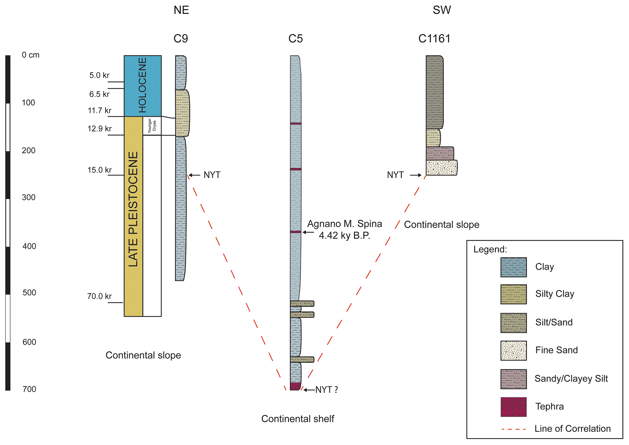
Figure 8Stratigraphy of the cores C9 (Amore et al., 2000), C5 (Misuraca et al., 2018) and C1161 (Iorio et al., 2014), used for the calibration of the NYT reflector. The location of the known (cores C9 and C1161) and hypothized (Core C5) NYT tephra has also been reported. Legend as in figure.
5.2 Testing the northwards trend of the NYT deposits through core-correlation
The depths of the V reflector attributed to the NYT deposits, were reconstructed based on seismo-stratigraphic evidence, and their values were tested against the previously known (cores C9: Amore et al., 2000; C1161: Aiello et al., 2017) and hypothesized (core C5: Misuraca et al., 2018) depths of the NYT (Fig. 8). In the northern sector, where core C9 is located (Fig. 2), the stratigraphic analysis has allowed us to identify in the TST a prograding body, whose internal and external geometries suggest the correlation with the Younger Dryas climatic deterioration, that occurred around 11.5 ka BP (Kallel et al., 1997; McKenzie et al., 1998; Pellegrini et al., 2015; Incarbona et al., 2016; Trias-Navarro et al., 2023). Below this progradation and above the RV surface, the V reflector was identified. The stratigraphy of the core C9, which records the last climatic cycle in the Tyrrhenian Sea (Amore et al., 2000; Di Donato, 2002), shows that the Last Glacial period is represented from the base of the core up to 170 cm (Fig. 8), and that the deglaciation, in which events corresponding with the Younger Dryas have been identified, was recorded in the core interval ranging from 170 to 130 cm (Fig. 8). Finally, the upper part of the C9 core represents the Holocene. Always in core C9, the NYT depth occurrence is at 250 cm (Amore et al., 2000) and such depth corresponds to the depth of which the reflector V was calculated on seismic data in the area. Subsequently the V reflector, by means of stratigraphic analysis and correlation at the intersections of the dip trending seismic profiles with the Trans_0 profile, was reported back to the V reflector of Aiello et al., 2017, permitting us to reassess the position of V down to the southern sector. So far in the central sector, offshore the Volturno delta and where the thickness is higher, the V reflector's depth has been calculated at about 7 m below sea floor (Chirp profile 194 in Fig. 5a). This finding is in agreement with the position of an uncharacterized tephra (Fig. 8) found at 710 cm, in core C5, far below the Agnano Mt. Spina tephra (4.2 kyr BP, Margaritelli et al., 2016; Misuraca et al., 2018), which was recovered very close to profile 194 (Fig. 2). So far it is hypothesized that the V reflector and the uncharacterized tephra in core C5 correspond to each other's and that they are probably constituted by NYT deposits. Moreover, in the southern sector the V reflector was correlated with the tephra occurrence within the TST deposits (Figs. 4 and 5), sampled by core C1161 and previously attributed to NYT deposits throughout petrophysical analysis (Iorio et al., 2014; Aiello et al., 2017). At this point it is interesting to notice that, the V reflector depth in the continental slope, immediately beyond the shelf break which is characterized by a thin sedimentary thickness, is equivalent, based on C9 and C1161 core correlation, for both the northern and the southern sector of the Gulf (Fig. 8). So far having identified that the NYT deposits spreads all over the Gaeta continental shelf, and that constitute a continuous seismic reflector, depth isopach maps were obtained for it (Figs. 6 and 7). In Fig. 6 the depth isopach maps obtained show a surface dipping towards the south-west, while the sedimentary thickness above the NYT deposits (Fig. 7), increases from north to south, with a clear depocenter located southwards of the Volturno delta. Several different driving processes could be hypothesized in order to explain this sedimentation trend. The particular geometry of the NYT (in terms of depth and thickness) in the Volturno area could be related to the presence of an incised valley system, identified by Amorosi et al. (2012). Another process could concern the alongshore currents, which in the area indicate a regular trend of solid transport from NW towards the SE (Cocco et al., 1986; Pennetta et al., 2016, and references therein). Furthermore, the structural setting of the area presents normal faults that lower portions of the continental shelf in the NNW-SSE direction (Bartole, 1984; Conti et al., 2017) and this structural asset could have led to an increase in the accommodation space. Finally, another important aspect to consider is the compaction and subsidence processes that are observed in prodelta areas of continental shelves, where the overall load effect of local tectonics, sediment and hydrostatic loading enlarges the accommodation space and promotes the accumulation and preservation of sediment deposits (Liquete et al., 2008). Considering the sediment thickness above the NYT (Fig. 7), it is possible to estimate a sedimentation rate of approximately 2.5 mm yr−1, value that seems to suggest a strong sediment compaction as driving mechanism for the Late Glacial/Holocene sediments accumulation of the Gaeta shelf. However, it must be kept in mind that sedimentation cannot be considered constant in this time interval, as other eruptions have occurred (i.e. Agnano Monte Spina among others, Fig. 8). Due to this finding, we may state that the Volturno delta sourced a significant sediment supply on the continental shelf during the Holocene (Barra et al., 1996; Bellotti, 2000; Romano et al., 1994; Amorosi et al., 2012; Ruberti et al., 2018, 2022). This supply has fed the TST and HST deposits (Figs. 4 and 5), which have an exceptionally high thickness in the study area.
The stratigraphic architecture in the Upper Pleistocene–Holocene of the Gul of Gaeta is characterized by an offlap prograding succession followed by a very thick transgressive onlapping unit, and by an upper highstand unit mainly characterized by undulations probably linked to gas-prone sediment. Furthermore, the NYT reflector is parallel with a high amplitude and it was continuously detected from the shelf to the slope. The results obtained in this paper have highlighted that the NYT deposits, located within the TST, both in southern and northern sectors of the Gaeta Gulf, represent a prominent, laterally continuous volcanic marker throughout the entire Gaeta Gulf. So far this finding, adds information about the characterization and diffusion of an important isochronous marker on the Eastern Tyrrhenian margin and finally, the NYT depth and isopach maps obtained, will allow to further deepen the structural knowledge of the study area and the development of volcanic hazard maps for an area densely populated as that of PF.
All data for this study are presented in the paper: Figs. 2–8, and Sect. 4.
Conceptualization: MI, AM, GA, MRS; data collection and methodology: MI, AM, GA, MRS; validation: MI, AM, GA, MRS; data analysis: MRS; writing-original draft preparation: MI, AM, GA, MRS; writing-review and editing: MI, AM, GA, MRS; visualization, MI, AM, GA, MRS; funding acquisition: MI, GA, MRS. The authors have read and agreed to the published version of the manuscript.
The contact author has declared that none of the authors has any competing interests.
Publisher's note: Copernicus Publications remains neutral with regard to jurisdictional claims made in the text, published maps, institutional affiliations, or any other geographical representation in this paper. While Copernicus Publications makes every effort to include appropriate place names, the final responsibility lies with the authors.
This article is part of the special issue “New advances on the geology of the central–western Mediterranean area (EGU 2023 SSP1.7 session)”. It is a result of the EGU General Assembly 2023, Vienna, Austria, 23–28 April 2023.
This research is financially supported by the Campania Region (CARG 1:50 000 project, 2003) and by the University of Sannio (Fondi di Ricerca di Ateneo – FRA). Alessandro Amorosi and an anonymous reviewer are greatly appreciated for their comments and suggestions which significantly improved the manuscript.
This paper was edited by Roberta Somma and reviewed by Alessandro Amorosi and one anonymous referee.
Acocella, V.: Activating and reactivating pairs of nested collapses during caldera forming eruptions: Campi Flegrei (Italy). Geophys. Res. Lett., 35, L17304, https://doi.org/10.1029/2008GL035078, 2008.
Aiello, G.: The Volturno Basin (Southern Italy): insights into the seismo-stratigraphy and structure of the Campania Plain (Southern Italy), Horizons Earth Sci. Res., 17, 1–37, https://doi.org/10.3390/jmse10101520, 2017.
Aiello, G.: A review of the CARG Project of the Campania Region (marine counterpart; southern Tyrrhenian Sea): New perspectives in marine geology and cartography, J. Geogr. Cartogr., 6, 1–28, https://doi.org/10.24294/jgc.v6i1.1855, 2023.
Aiello, G. and Caccavale, M.: The Coastal Areas of the Bay of Naples: The Sedimentary Dynamics and Geological Evolution of the Naples Canyons, Geosciences, 13, 226, https://doi.org/10.3390/geosciences13080226, 2023a.
Aiello, G. and Caccavale, M.: A Seismo-Stratigraphic Analysis of the Relict Deposits of the Cilento Continental Shelf (Southern Italy), Proceedings, 87, 10, https://doi.org/10.3390/IECG2022-14296, 2023b.
Aiello, G. and Cicchella, A. G.: Dati sismostratigrafici sul margine continentale della Campania tra Ischia, Capri ed il bacino del Volturno (Tirreno meridionale, Italia) in base al processing sismico ed all'interpretazione geologica di profili sismici a riflessione multicanale, Quad. Geof., 149, 1–52, 2019.
Aiello, G., Cicchella, A. G., Di Fiore, V., and Marsella, E.: New seismo-stratigraphic data of the Volturno Basin (northern Campania, Tyrrhenian margin, southern Italy): implications for tectono-stratigraphy of the Campania and Latium sedimentary basins. Ann. Geophys., 54, 265–283, https://doi.org/10.4401/ag-4777, 2011.
Aiello, G., Insinga, D. D., Iorio, M., Meo, A., and Senatore, M. R.: On the occurrence of the Neapolitan Yellow Tuff tephra in the Northern Phlegraean Fields offshore (Eastern Tyrrhenian margin; Italy), Ital. J. Geosci., 136, 263–274, https://doi.org/10.3301/IJG.2017.06, 2017.
Aiello, G., Marsella, E., and Sacchi, M.: Quaternary structural evolution of Terracina and Gaeta basins (Eastern Tyrrhenian margin, Italy), Rend. Lincei, Sci. Fis. Nat., 11, 41–58, 2000.
Aiello, G., Iorio, M., Molisso, F., and Sacchi, M.: Integrated Morpho-Bathymetric, Seismic Stratigraphic, and Sedimentological Data on the Dohrn Canyon (Naples Bay, Southern Tyrrhenian Sea): Relationships with Volcanism and Tectonics, Geosciences, 10, 319, https://doi.org/10.3390/geosciences10080319, 2020.
Amore, F. O., Ciampo, G., Di Donato, V., Esposito, P., Russo Ermolli, E., and Staiti, D.: An integrated micropalaeontological approach applied to Late Pleistocene-Holocene palaeoclimatic and palaeoenvironmental change (Gaeta Bay, Tyrrhenian Sea), in: Climates: Past and Present, edited by: Hart, M. B., Geol. Soc. Lond. Spec. Publ., 118811, 95–111, https://doi.org/10.1144/GSL.SP.2000.181.01.10, 2000.
Amorosi, A., Pacifico, A., Rossi, V., and Ruberti, D.: Late Quaternary incision and deposition in an active volcanic setting: The Volturno valley fill, southern Italy, Sed. Geol., 282, 307–320, https://doi.org/10.1016/j.sedgeo.2012.10.003, 2012.
Barra, D., Romano, P., Santo, A., Campajola, L., Roca, V., and Tuniz, C.: The versilian transgression in the Volturno river plain: palaeoenvironmental history and chronological data, Il Quaternario, 10, 571–578, 1996.
Bartole, R.: Tectonic structures of the Latian-Campanian shelf (Tyrrhenian Sea), Boll. Ocean. Teoritica Appl., 2, 197–230, 1984.
Bartole, R., Savelli, C., Tramontana, M., and Wezel, F. C.: Structural and sedimentary features in the Tyrrhenian margin off Campania, southern Italy, Mar. Geol., 55, 163–180, https://doi.org/10.1016/0025-3227(84)90067-7, 1983.
Bassetti, M. A., Berné, S., Jouet, G., Taviani, M., Dennielou, B., Flores, J.-A., Gaillot, A., Gelfort, R., Lafuerza, S., and Sultan, N.: The 100 ka and rapid sea level changes recorded by prograding shelf sand bodies in the Gulf of Lions (western Mediterranean Sea), Geochem. Geophys. Geosyst., 9, 1–27, https://doi.org/10.1029/2007GC001854, 2008.
Bellotti, P.: Il modello morfo-sedimentario dei maggiori delta tirrenici italiani, Boll. Soc. Geol. Ital., 119, 777–792, 2000.
Bourne, A. J., Lowe, J. J., Trincardi, F., Asioli, A., Blockley, S. P. E., Wulf, S., Matthews, I. P., Piva, A., and Vigliotti L.: Distal tephra record for the last ca 105,000 years from core PRAD 1–2 in the central Adriatic Sea: implications for marine tephrostratigraphy, Quaternary Sci. Rev., 29, 3079–3094, https://doi.org/10.1016/j.quascirev.2010.07.021, 2010.
Buccheri, G., Capretto, G., Di Donato, V., Esposito, P., Ferruzza, G., Pescatore, T., Russo Ermolli, E., Senatore, M. R., Sprovieri, M., Bertoldo, M., Carella, D., and Madonia, G.: A high resolution record of the last deglaciation in the southern Tyrrhenian Sea: environmental and climatic evolution, Mar. Geol., 186, 447–470, https://doi.org/10.1016/S0025-3227(02)00270-0, 2002.
Catuneanu, O.: Model-independent sequence stratigraphy, Earth Sci. Rev., 188, 312–388, https://doi.org/10.1016/j.earscirev.2018.09.017, 2019.
Catuneanu, O., Abreu, V., Bhattacharya, J. P., Blum, M. D., Dalrymple, R. W., Eriksson, P. G., Fielding, C. R., Fisher, W. L., Galloway, W. E., Gibling, M. R., Giles, K. A., Holbrook, J. M., Jordan, R., Kendall C. G. St. C., Macurda, B., Martinsen, O. J., Miall, A. D., Neal, J. E., Nummedal, D., Pomar, L., and Winker, C.: Towards the standardization of sequence stratigraphy, Earth Sci. Rev., 92, 1–33, https://doi.org/10.1016/j.earscirev.2008.10.003, 2009.
Cocco, E., De Pippo, T., and Giulivo, I.: Dinamica ed evoluzione del litorale campano-laziale: 4. Il settore costiero compreso tra Minturno e Baia Domitia (F. Garigliano), Mem. Soc. Geol. Ital., 35, 805–809, 1986.
Conti, A., Bigi, S., Cuffaro, M., Doglioni, C., Scrocca, D., Muccini, F., Cocchi, L., Ligi, M., and Bortoluzzi, G.: Transfer zones in an oblique back-arc basin setting: Insights from the Latium-Campania segmented margin (Tyrrhenian Sea), Tectonics, 36, 78–107, https://doi.org/10.1002/2016TC004198, 2017.
Corradino, M., Pepe, F., Sacchi, M., Solaro, G., Duarte, H., Ferranti, L., and Zinno, I.: Resurgent uplift at large calderas and relationship to caldera-forming faults and the magma reservoir: New insights from the Neapolitan Yellow Tuff caldera (Italy), J. Volcanol. Geotherm. Res., 411, 107183, https://doi.org/10.1016/j.jvolgeores.2021.107183, 2021.
Deino, A. L., Orsi, G., De Vita, S., and Piochi, M.: The age of the Neapolitan Yellow Tuff caldera-forming eruption (Campi Flegrei caldera, Italy) assessed by 40Ar/39Ar dating method, J. Volcanol. Geotherm. Res., 91, 269–301, https://doi.org/10.1016/S0377-0273(03)00396-2, 2004.
De Vivo, B., Harvey, E. Belkin, H. E., and Rolandi, G. (Eds.): Vesuvius, Campi Flegrei, and Campanian Volcanism, Elsevier, https://doi.org/10.1016/B978-0-12-816454-9.12001-2, 2020.
Di Donato, V.: Effects of Late Pleistocene-Holocene climatic changes of the planktonic foraminfera in the Gulf of Gaeta (Tyrrhenian Sea, Italy), Il Quaternario (It. J. Quat. Sci), 15, 251–257, 2002.
Di Vito, M. A., Isaia, R., Orsi, G., Southon, J., De Vita, S., D'Antonio, M., Pappalardo, L., and Piochi, M.: Volcanic and deformational history of the Campi Flegrei caldera in the past 12 ka, J. Volcanol. Geoth. Res., 91, 221–246, https://doi.org/10.1016/S0377-0273(99)00037-2, 1999.
Frezza, V., Argenti, L., Bonifazi, A., Chiocci, F. L., Di Bella, L., Ingrassia, M., and Martorelli, E.: Benthic Foraminiferal Assemblages and Rhodolith Facies Evolution in Post-LGM Sediments from the Pontine Archipelago Shelf (Central Tyrrhenian Sea, Italy), Geosciences, 11, 179, https://doi.org/10.3390/geosciences11040179, 2021.
Galloway, W. E.: The many faces of submarine erosion: theory meets reality in selection of sequence boundaries, in: AAPG Hedberg Research Conference on “Sequence Stratigraphic and Allostratigraphic Principles and Concepts”, 26–29 August 2001, Dallas, 2001.
Giaccio, B., Isaia, R., Fedele, F. G., Di Canzio, E., Hoffecker, J., Ranchitelli, A., Sinitsyn, A. A., Anikovich, M., Lisitsyn, S. N., and Popov, V. V.: The Campanian Ignimbrite and Codola tephra layers: two temporal/stratigraphic markers for the early upper Palaeolithic in southern Italy and eastern Europe, J. Volcanol. Geoth. Res., 177, 208–226, https://doi.org/10.1016/j.jvolgeores.2007.10.007, 2008.
Incarbona, A., Di Stefano, E., Sprovieri, R., and Ferraro, S.: The Uniqueness of Planktonic Ecosystems in the Mediterranean Sea: The Response to Orbital- and Suborbital-Climatic Forcing over the Last 130,000 Years, Open Geosci., 8, 567–578, https://doi.org/10.1515/geo-2016-0050, 2016.
Insinga, D. D., Tamburrino, S., Lirer, F., Vezzoli, L., Barra, M., De Lange, G. J., Tiepolo, M., Vallefuoco, M., Mazzola, S., and Sprovieri, M.: Tephrochronology of the astronomically-tuned KC01B deep-sea core, Ionian Sea: insights into the explosive activity of the Central Mediterranean area during the last 200 ka, Quaternary Sci. Rev., 85, 63–84, https://doi.org/10.1016/j.quascirev.2013.11.019, 2014.
Iorio, M., Capretto, G., Petruccione, E., Marsella, E., Aiello, G., and Senatore, M. R.: Multi-proxy analysis in defining sedimentary processes in very recent prodelta deposits: The Northern Phlegraean offshore example (Eastern Tyrrhenian Margin), Rend. Lincei. Sci. Fis. Nat., 25, 237–254, https://doi.org/10.1007/s12210-014-0303-3, 2014.
Kallel, N., Paterne, M., Labeyrie, L., Duplessy, J. C., and Arnold, M.: Temperature and salinity records of the Tyrrhenian Sea during the last 18,000 years, Palaeogeogr. Palaeocl., 135, 97–108, https://doi.org/10.1016/S0031-0182(97)00021-7, 1997.
Liquete, C., Canals, M., De Mol, B., De Batist, M., and Trincardi, F.: Quaternary stratal architecture of the Barcelona prodeltaic continental shelf (NW Mediterranean), Mar. Geol, 250, 234–250, https://doi.org/10.1016/j.margeo.2008.01.014, 2008.
Loreto, M. F., Zitellini, N., Ranero, C., and Palmiotto, C.: Prada M. Extensional tectonics during the Tyrrhenian back-arc basin formation and a new morpho-tectonic map, Basin Res., 33, 138–158, https://doi.org/10.1111/bre.12458, 2021.
Lykousis, V., Karageorgis, A., and George, Th.: Chronis Delta progradation and sediment fluxes since the last glacial in the Thermaikos Gulf and the Sporades Basin, NW Aegean Sea, Greece, Mar. Geol., 222–223, 381–397, https://doi.org/10.1016/j.margeo.2005.06.026, 2005.
Margaritelli, G., Vallefuoco, M., Di Rita, F., Capotondi, L., Bellucci, L. G., Insinga, D. D., Petrosino, P., Bonomo, S., Cacho, I., Cascella, A., Ferraro, L., Florindo, F., Lubritto, C., Lurcock, P. C., Magri, D., Pelosi, N., Rettori, R., and Lirer, F.: Marine response to climate changes during the last five millennia in the central Mediterranean Sea, Global Planet. Change, 142, 53–72, https://doi.org/10.1016/j.gloplacha.2016.04.007, 2016.
McKenzie, J. A., Sbaffi, L., Wezel, F. C., and Tamburini, F.: Late Quaternary climatic variations on the Latium and Campanian Margin of the Tyrrhenian Sea, Rend. Lincei. Sci. Fis. Nat., 9, 293–313, https://doi.org/10.1007/BF02904440, 1998.
Milia, A. and Torrente, M. M.: Space-time evolution of an active volcanic field in an extensional region: The example of the Campania margin (eastern Tyrrhenian Sea), in: Vesuvius, Campi Flegrei, and Campanian Volcanism, 1st edn., edited by: De Vivo, B., Belkin, H., and Rolandi, G., Elsevier, New York, NY, USA, 297–321, https://doi.org/10.1016/B978-0-12-816454-9.00012-2, 2020.
Misuraca, M., Budillon, F., Tonielli, R., Di Martino, G., Innangi, S., and Ferraro, L.: Coastal Evolution, Hydrothermal Migration Pathways and Soft Deformation along the Campania Continental Shelf (Southern Tyrrhenian Sea): Insights from High-Resolution Seismic Profiles, Geosciences, 8, 121, https://doi.org/10.3390/geosciences8040121, 2018.
Morabito, S., Petrosino, P., Milia, A., Sprovieri, M., and Tamburrino, S.: A multidisciplinary approach for reconstructing the stratigraphic framework of the last 40ka in a bathyal area of the eastern Tyrrhenian Sea, Global Planet. Change Part A, 123, 121–138, https://doi.org/10.1016/j.gloplacha.2014.10.005, 2014.
Orsi, G.: Volcanic and Deformation History of the Campi Flegrei Volcanic Field, Italy, in: Campi Flegrei. Active Volcanoes of the World, edited by: Orsi, G., D'Antonio, M., and Civetta, L., Springer, Berlin, Heidelberg, https://doi.org/10.1007/978-3-642-37060-1_1, 2022.
Ortolani, F. and Aprile, F.: Nuovi dati sulla struttura profonda della Piana Campana a sud-est del fiume Volturno, Boll. Soc. Geol. Ital., 97, 591–608, 1978.
Paterne, M., Guichard, F., and Labeyrie, J.: Explosive activity of the South Italian volcanoes during the past 80,000 years as determined by marine tephrochronology, J. Volcanol. Geoth. Res., 34, 153–172, https://doi.org/10.1016/0377-0273(88)90030-3, 1988.
Pellegrini, C., Maselli, V., Cattaneo, A., Piva, A., Ceregato, A., and Trincardi, F.: Anatomy of a compound delta from the post-glacial transgressive record in the Adriatic Sea, Mar. Geol., 362, 43–59, https://doi.org/10.1016/j.margeo.2015.01.010, 2015.
Pennetta, M., Brancato, V. M., DeMuro, S., Gioia, D., Kalb, C., Stanislao, C., Valente, A., and Donadio, C.: Morpho-sedimentary features and sediment transport model of the submerged beach of the “Pineta della foce del Garigliano” SCI Site (Caserta, southern Italy), J. Maps, 12, 139–146, https://doi.org/10.1080/17445647.2016.1171804, 2016.
Posamentier, H. W.: The “Healing Phase” – a Commonly Overlooked Component of the Transgressive Systems Tract, AAPG Search and Discovery Article AAPG Annual Convention, New Orleans, Louisiana, 25–28 April, 1993.
Posamentier, H. W. and Allen, G. P.: Variability of the sequence stratigraphic model: effects of local basin factors, Sed. Geol., 86, 91–109, https://doi.org/10.1016/0037-0738(93)90135-R, 1993.
Posamentier, H. W. and Vail, P. R.: Eustatic controls on clastic deposition II – sequence and systems tract models, in: Sea Level Changes: An integrated approach, edited by: Wilgus, C. K., Hastings, B. S., Posamentier, H., Van Wagoner, J., Ross, C. A., and Kendall, C. G., SEPM Spec. Publ., 42, Tulsa, Oklahoma, 125–154, https://doi.org/10.2110/pec.88.01.0125, 1988.
Ridente, D.: Late Pleistocene Post-Glacial Sea Level Rise and Differential Preservation of Transgressive “Sand Ridge” Deposits in the Adriatic Sea, Geosciences, 8, 61, https://doi.org/10.3390/geosciences8020061, 2018.
Rolandi, G., Di Lascio, M., and Rolandi, R.: Chapter 11 – The Neapolitan Yellow Tuff eruption as the source of the Campi Flegrei caldera, in: Vesuvius, Campi Flegrei, and Campanian Volcanism, edited by: De Vivo, B., Harvey, E., Belkin, H. E., and Rolandi, G., 273–296, Elsevier, https://doi.org/10.1016/B978-0-12-816454-9.00011-0, 2020.
Romano, P., Santo, A., and Voltaggio, M.: L'evoluzione geomorfologica della pianura del fiume Volturno (Campania) durante il tardo Quaternario (Pleistocene Medio-Superiore-Olocene), Il Quaternario, 7, 41–58, 1994.
Ruberti, D., Sacchi, M., Pepe, F., and Vigliotti, M.: LGM Incised Valley In a Volcanic Setting. The Northern Campania Plain (Southern Italy), Alp. Mediterr. Quat., 31, 35–38, 2018.
Ruberti, D., Buffardi, C., Sacchi, M., and Vigliotti, M.: The late Pleistocene-Holocene changing morphology of the Volturno delta and coast (northern Campania, Italy): Geological architecture and human influence, Quaternary Int., 625, 14–28, https://doi.org/10.1016/j.quaint.2022.03.023, 2022.
Sacchi, M., Pepe, F., Corradino, M., Insinga, D. D., Molisso, F., and Lubritto, C.: The Neapolitan Yellow Tuff caldera offshore the Campi Flegrei: Stratal architecture and kinematic reconstruction during the last 15 kyr, Mar. Geol., 354, 15–33, https://doi.org/10.1016/j.margeo.2014.04.012, 2014.
Sartori, R., Torelli, L., Zitellini, N., Carrara, G., Magaldi, M., and Mussoni, P.: Crustal features along a W–E Tyrrhenian transect from Sardinia to Campania margins (Central Mediterranean), Tectonophysics, 383, 171–192, https://doi.org/10.1016/j.tecto.2004.02.008, 2004.
Sawyer, D. E., Urgeles, R., and Lo Iacono, C.: 50,000 yr of recurrent volcaniclastic megabed deposition in the Marsili Basin, Tyrrhenian Sea, Geology, 51, 1001–1006, https://doi.org/10.1130/G51198.1, 2023.
Schmidt, R., van den Bogaard, C., Merkt, J., and Müller, J.: A new Lateglacial chronostratigraphic tephra marker for the south-eastern Alps: The Neapolitan Yellow Tuff (NYT) in Längsee (Austria) in the context of a regional biostratigraphy and palaeoclimate, Quat. Int., 88, 45–56, https://doi.org/10.1016/S1040-6182(01)00072-6, 2002.
Silleni, A., Giordano, G., Isaia, R., and Ort, M.: The Magnitude of the 39.8 ka Campanian Ignimbrite Eruption, Italy: Method, Uncertainties and Errors, Front. Earth Sci., 8, https://doi.org/10.3389/feart.2020.543399, 2020.
Smith, V. C., Isaia, R., and Pearce, N. J. G.: Tephrostratigraphy and glass compositions of post 15-kyr Campi Flegrei eruptions: implications for eruption history and chronostratigraphic markers, Quaternary Sci. Rev., 30, 3638–3660, https://doi.org/10.1016/j.quascirev.2011.07.012, 2011.
Tomlinson, E. L., Albert, P. G., and Menzies, M. A.: Tephrochronology and Geochemistry of Tephra from the Campi Flegrei Volcanic Field, Italy, in: Campi Flegrei. Active Volcanoes of the World, edited by: Orsi, G., D'Antonio, M., and Civetta, L., Springer, Berlin, Heidelberg, https://doi.org/10.1007/978-3-642-37060-1_5, 2022.
Torrente, M. M. and Milia, A.: Volcanism and faulting of the Campania margin (Eastern Tyrrhenian Sea, Italy): a three-dimensional visualization of a new volcanic field off Campi Flegrei, Bull. Volcanol., 75, 719, https://doi.org/10.1007/s00445-013-0719-0, 2013.
Torrente, M. M., Milia, A., and Tesauro, M.: Comment on Loreto et al., 2021: Extensional tectonics during the Tyrrhenian back-arc basin formation and a new morpho-tectonic map, Basin Res., 28 August 2023, https://doi.org/10.1111/bre.12817, 2023.
Totaro, F., Insinga, D. D., Lirer, F., Margaritelli, G., Català i Caparrós, A., de la Fuente, M., and Petrosino, P.: The Late Pleistocene to Holocene tephra record of ND14Q site (southern Adriatic Sea): traceability and preservation of Neapolitan explosive products in the marine realm, J. Volcanol. Geoth. Res., 423, 107461, https://doi.org/10.1016/j.jvolgeores.2021.107461, 2022.
Trias-Navarro, S., Pena, L. D., de la Fuente, M., Paredes E., Garcia-Solsona, E., Frigola, J., Català, A., Caruso, A., Lirer, F., Haghipour, N., Pérez-Asensio, J. N., and Cacho, I.: Eastern Mediterranean water outflow during the Younger Dryas was twice that of the present day, Commun. Earth Environ., 4, 147, https://doi.org/10.1038/s43247-023-00812-7, 2023.
Trincardi, F. and Field, M. E.: Geometry, lateral variation, and preservation of downlapping regressive shelf deposits: eastern Tyrrhenian Sea margin, Italy, J Sediment. Petrol., 6, 775–790, https://doi.org/10.1306/D42677D0-2B26-11D7-8648000102C1865D, 1991.
Trincardi, F. and Zitellini, N.: The rifting of the Tyrrhenian basin, Geo Mar. Lett., 7, 1–6, https://doi.org/10.1007/BF02310459, 1987.
Van Wagoner, J. C., Posamentier, H. W., Mitchum, R. M., Vail, P. R., Sarg, J. F., Loutit, T. S., and Hardenbol, J.: An overview of sequence stratigraphy and key definitions, in: Sea Level Changes – An Integrated Approach, edited by: Wilgus, C. K., Hastings, B. S., Kendall, C. G. St. C., Posamentier, H. W., Ross, C. A., Van Wagoner, J. C., SEPM Spec. Publ., 42, 39–45, 1988.
Zecchin, M. and Catuneanu, O.: High-resolution sequence stratigraphy of clastic shelves I: units and bounding surfaces, Mar. Pet. Geol., 39, 1–25, https://doi.org/10.1016/j.marpetgeo.2012.08.015, 2013.
Zecchin, M., Catuneanu, O., and Caffau, M.: Wave-ravinement surfaces: Classification and key characteristics, Earth Sci. Rev., 188, 210–239, https://doi.org/10.1016/j.earscirev.2018.11.011, 2019.