 | 17 Dec 2025
Storm Erwin: societal and energy impacts in northern Europe on 7–9 January 2005
Anthony J. Kettle
On 7–9 January 2005 Storm Erwin (known as Storm Gudrun in the Nordic countries) passed across northern Europe causing damage and interrupting power and transportation networks from Ireland to the eastern Baltic region. In northern England the storm was associated with severe river flooding around Carlisle that cut transportation links into the city and necessitated evacuations. In Scandinavia strong winds were reported, resulting in large scale forest damage and power outages. In Denmark, wind energy was impacted as wind speeds crossed the 25 m s−1 cut-off threshold for turbine operations, leading to a mass shut down of wind turbines and requiring electricity to be imported to make up the shortfall. In Sweden, there were widespread power outages as transmissions lines were blown down in the winds, and coastal nuclear power plants were shut down when sea spray caused short-circuiting problems in electricity transmission. The storm was associated with a notable coastal surge and flooding, particularly in Denmark and the eastern Baltic. The present contribution gives an overview of how the storm affected infrastructure as well as other societal impacts. During Storm Britta in 2006 there was important wave strike damage to offshore energy infrastructure across the North Sea, motivating a review of other North Sea severe storms for comparable impacts. A detailed analysis of tide gauge and wave data is conducted to understand the surge and possible meteotsunamis and rogue waves during Storm Erwin. While the storm caused severe wind-related damage onshore, shipping and offshore energy production were less affected compared with other storms of the past 40 years.
- Article
(7095 KB) - Full-text XML
-
Supplement
(4525 KB) - BibTeX
- EndNote


For its impact on European electricity production and distribution systems, Storm Erwin (or Storm Gudrun in the Nordic countries) on 7–9 January was a remarkable event, even on the scale of the worst winter storms of the past 40 years. The storm centre moved along a trajectory across Scotland, southern Norway, Sweden and Finland causing high winds and infrastructure damage in a narrow latitude band south of the cyclone centre between Ireland and Russia (Guy Carpenter, 2005; Suursaar et al., 2006).
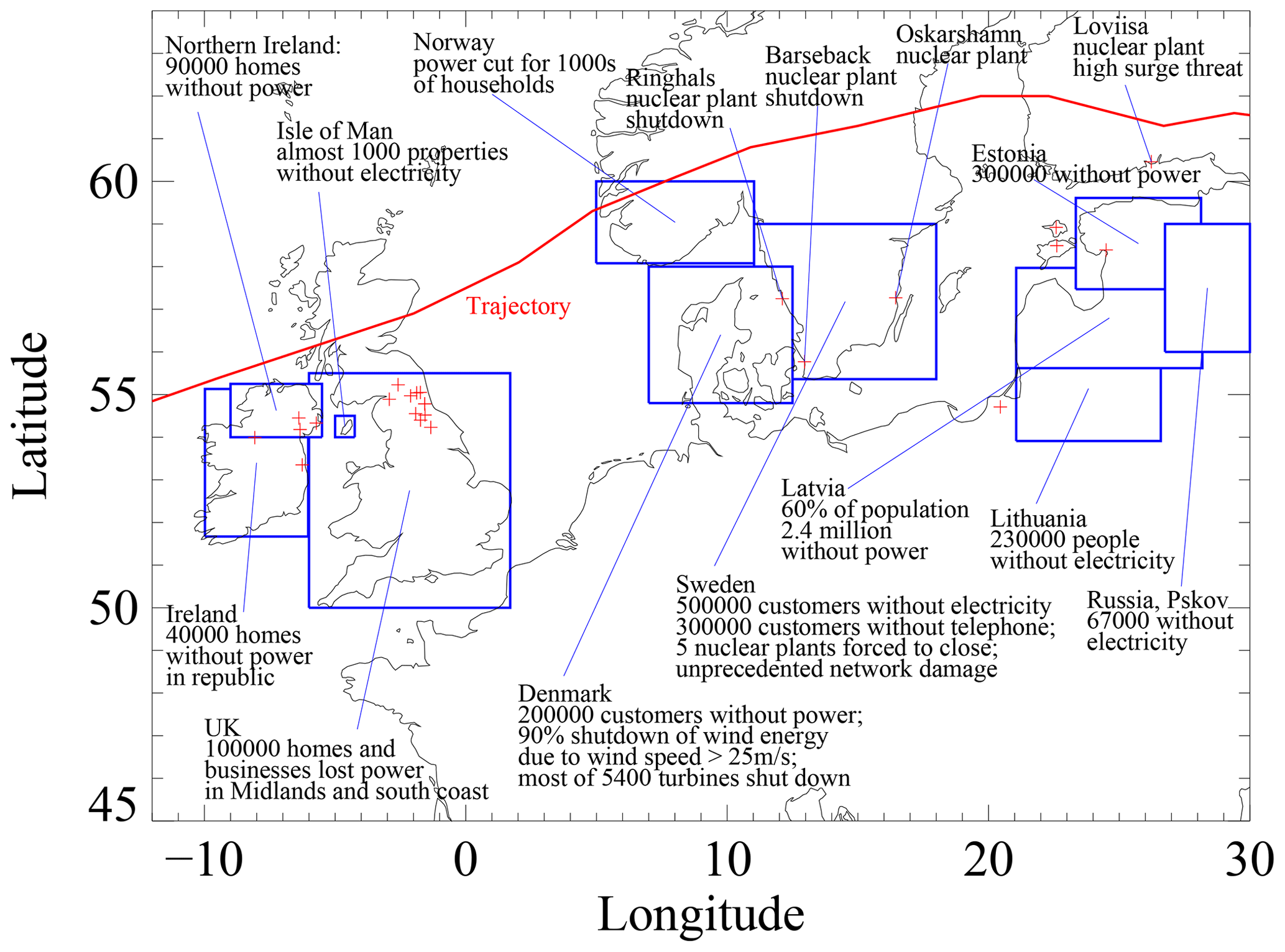
Figure 1Thematic map of power outages, energy infrastructure damage, and nuclear station incidents that were reported in the literature for Storm Erwin 8–9 January 2005. The trajectory of the low pressure centre is given by the thick red line. Blue boxes delimit countries and larger regions with a printed summary of energy impacts.
Electricity networks were particularly affected by the intense rainfall and powerful winds (Fig. 1). The electricity blackouts across northern Europe started first in Ireland with 150 000 customers without power (Guardian, 2005; Guy Carpenter, 2005). The Isle of Man between Ireland and the UK experienced blackouts due to the high winds (Hisscott, 2007). In northern Wales, northwest England and western Scotland, high rainfall accumulations occurred early in the storm period on 7 January 2005. This led to severe flooding at Carlisle in north-western England with associated loss of electricity for 70 000 customers in the city (BBC, 20050110). Electricity blackouts were reported in southern Norway with some associated problems for oil production in that country (Alexandersson and Ivarsson, 2005; Guy Carpenter, 2005). In southern Sweden the storm damage to the electricity system was unprecedented, and there were power outages for 730 000 people (Guy Carpenter, 2005; Haanpää et al., 2006; Klee and Noren, 2006). High winds toppled large tracts of forest bringing down power lines and transmission masts at the same time (Beredskabstyrelsen, 2005; Haanpää et al., 2006). In addition, high winds along the west coast of Sweden generated large amounts of sea spray (a “saltstorm”) which caused short circuiting problems at the coastal nuclear power station of Ringhals, leading to its shut-down. The nuclear station of Barsebäck, also on the west coast, was also shut down during the storm due to grid failure (Haanpää et al., 2006; Johansson et al., 2006; Wikipedia, 2025). To overcome the loss of these two important electricity sources, power was transferred from northern Sweden and Norway (Hallands Nyheder, 2005), outside the impact area of the storm. In Denmark, ∼200 000 households lost electricity, mostly due to power lines damaged by falling trees (Danish Energy Agency, 2016). Problems with electricity production also arose when wind speeds exceeded the 25 m s−1 operational threshold of the country's ∼5400 wind turbines, leading to a 90 %–95 % loss of wind energy production (Danish Energy Authority, 2005; Haanpää et al., 2006). The shortfall was supplied with cross border links through the European grid, but these electricity transfer systems were challenged when the storm also led to the loss of the nuclear generation sources in Sweden (ClimateChangePost, 2024). On the hand, annual statistics from the Nordic electricity transmission network operator (Nordel) indicate that the electrical system was not strained during the storm, and that the maximum system loads occurred later in the winter, most notably during very cold weather in the first week of March (Klee and Noren, 2006). Although the storm had weakened as it passed over the Baltic and Finland, electricity blackouts also occurred in Estonia, Latvia, Lithuania, and neighbouring districts in Russia (BBC, 20050110; Haanpää et al., 2006). Part of these electrical outages were due to significant coastal flooding caused by the wind-forced storm surge, particularly in Estonia where ∼32 % of country's households lost power (Suursaar et al., 2006). In Finland, another nuclear power station (Loviisa) on the coast was placed at risk when water levels approached the station's operational limit for shutdown. Other nuclear power stations in the coastal areas of Finland and Russia were not jeopardized by the high water levels (Hellenberg and Kentala, 2008).
Other elements of societal infrastructure were affected by the storm, and these are outlined in Figs. S1–S7 in the Supplement. Roads networks experienced some cuts throughout the storm-impacted region. In Ireland, northern Wales, and northeast England this was mainly due to significant amounts of rainfall leading to river flooding. Heavy rain also occurred in southern Norway, leading to landslips and associated risks to roads (NRK, 2005; Krzystyniak, 2011). High winds toppled high-sided vehicles in north-eastern England, leading to some highway closures (Guardian, 2005). High winds also led to the closure of major bridges in Denmark, Sweden, and northern Germany (Deutsche Rück, 2006; Lloyds Casualty Week, 2005). However, the main impact of the high winds was to topple trees across roads. This was a problem on the Isle of Man (Hisscott, 2007) and particularly southern Sweden where reports indicated destruction of large tracts of forest with some cases of trees blown across roads in drifts 6–7 m high (Expressen, 2017). Coastal surge flooding closed some roads along the coasts of Norway, Sweden, Finland, and Estonia. The rail network of southern Sweden was completely shut down by the storm, mostly due to trees across the rails, with media reports of trains having to be evacuated between stations (Irish Times, 2005). Some rail services in Ireland and UK were also affected, mainly due to flooding. Disruptions to the air traffic were limited mainly to Denmark, where airplanes were diverted to Sweden and Germany during the height of the storm, and to Sturup airport near Malmo in Sweden (Irish Times, 2005; Lloyds Casualty Week, 2005). Ferry routes were interrupted in the Irish Sea, German Bight, eastern North Sea, and across the Baltic Sea. The most serious accident was the grounding of the ferry Highland Princess at Cairnryan in western Scotland with over 100 passengers on board (Lloyds Casualty Week, 2005). There were 17 fatalities during the storm in the UK, Germany, Denmark, and Sweden, with most killed in Sweden mainly in traffic accidents linked with falling trees.
Large-scale offshore wind farms were started in the North Sea in the early 2000s, with the Horns Rev turbine array constructed off the west coast of Denmark in 2002 (Danish Energy Authority, 2005) and the FINO1 research mast erected in the German Bight north of Borkum in the summer of 2003. Storm Erwin was the among the most severe North Sea storms that occurred in the first years of operation of these sites (Argyriadis et al., 2006). The storm helped to define the worst case environmental conditions that could be expected in the region, particularly as regards to wave conditions, which are important for the fatigue lifetime of engineered offshore structures (Emeis and Türk, 2009). In terms of offshore damage, Storm Erwin would be eclipsed during storm Britta on 1 November 2006 with its remarkable wave strike on the FINO1 met-ocean research platform in the southern North Sea (Pleskachevsky et al., 2012). The incident highlighted questions within the wind energy industry about the worst environmental conditions that can be expected during severe European winter storms, and maximum wave heights in coastal waters.
The goal of the present contribution is understand the met-ocean conditions during Storm Erwin, and to assess the storm surge and possible extreme wave conditions around the North Sea, an area of important offshore energy infrastructure in Europe. The storm was selected as a case study for possible extreme met-ocean conditions on the basis of the brief literature review presented above (see also Sect. S17). The media reports of coastal flooding and extreme winds marked the storm for further analysis of the geophysical records. In the following sections, a summary of the archived meteorological data is presented, followed by a detailed analysis of the water level data around the North Sea to assess if there were meteotsunamis or unusual seiche activity. Because high frequency offshore wave records are not generally available to document rogue waves (Kettle, 2024), the extensive North Sea tide gauge network provides a good resource to identify water level irregularities and damaging sea states. The contribution follows previous investigations of severe European storms (Kettle, 2018, 2019, 2020, 2021, 2023a, b, 2024).
The storm had a short, intense life cycle, forming in the eastern Atlantic just to the west of Ireland on 7 January 2005. It passed on a trajectory across Scotland, southern Norway, central Sweden, and Finland, before moving into Russia (Fig. 2; see also Guy Carpenter, 2005). The storm was distinguished by the rapid deepening of its central pressure with a rate of decrease of about 2 hPa h−1 between 09:00 UTC on 7 January and 15:00 UTC on 8 January 2005 when it culminated with a minimum central pressure of 960 hPa in southern Norway (Fig. S9). This rate of decrease was about twice as great as the threshold of 1 hPa h−1 that defines a “meteorological bomb” (Sanders and Gyakum, 1980), and it distinguished this storm as being one of the most intense European events of the last half century.
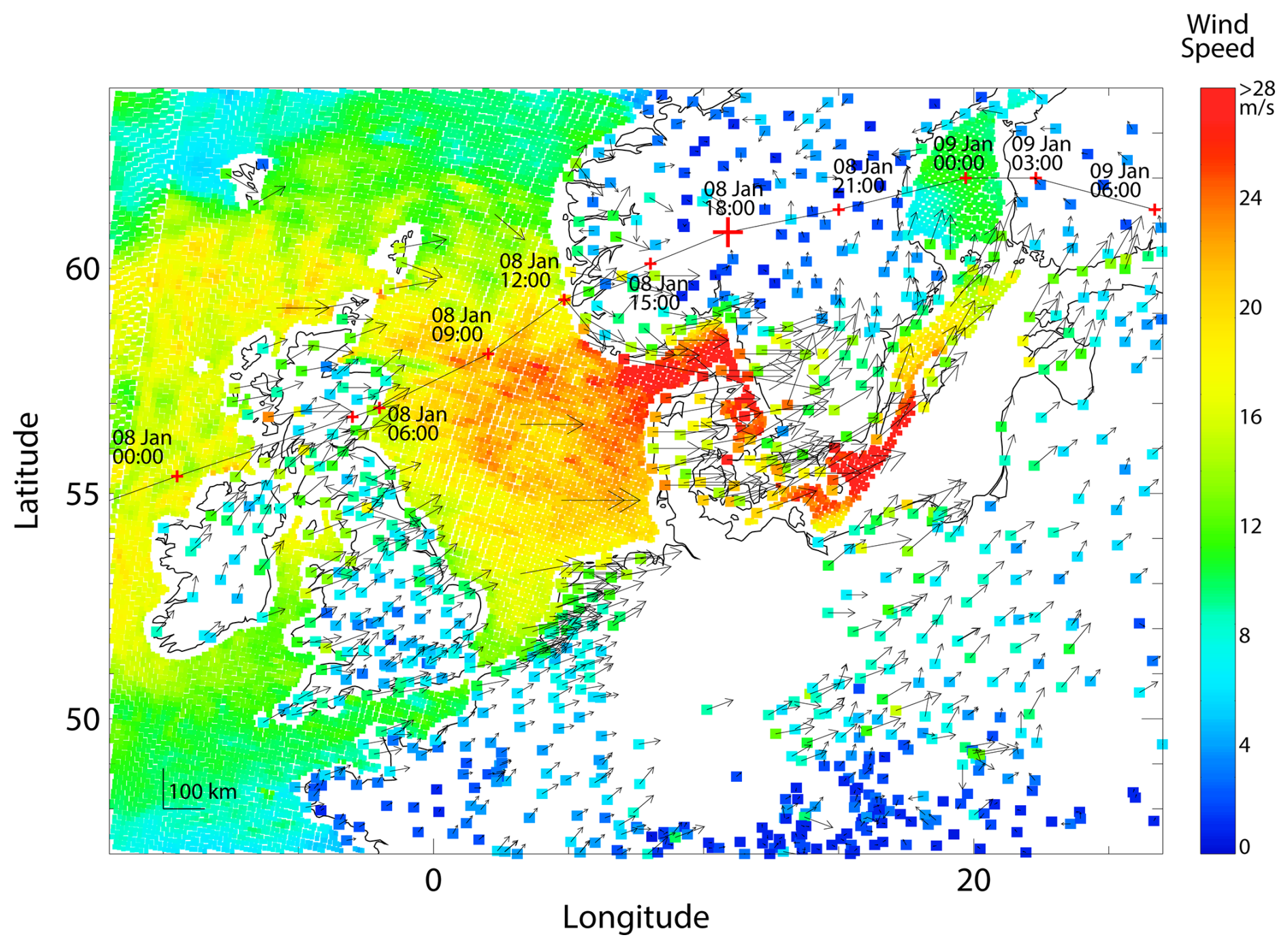
Figure 2Wind speed and direction for Storm Erwin at 18:00 UTC 8 January 2005 from selected stations of the USAF data set at the start of the period of extensive wind damage in southern Sweden. The trajectory of the low pressure centre is indicated by the black line with red crosses at 3 h intervals (Roberts et al., 2014; XWS, 2025). The location of the pressure centre at the time of the wind field is shown by a larger cross near the border between Norway and Sweden. The QuikSCAT sea surface wind speeds are shown for a satellite overpass at ∼ 18:45 UTC or ∼45 min after the synoptic station reports with a colour key at the right.
The storm was known for its very high winds and gusts. Sustained hurricane force winds were measured along the west coast of Denmark (Nielsen, 2023). Hurricane gusts were registered in the UK, Germany, Denmark, and Sweden (Beredeskapstyrelsen, 2005; Deutsche Rück, 2006; Nielsen, 2023; ESWD, 2024), with the highest gusts at the coastal stations at St. Bees Head in Cumbria in the UK and Hanstholm in Denmark (Wikipedia, 2025). Figure 2 shows measurements of the winds at 18:00 UTC on 8 January 2005 at about the time the storm impacts were starting to occur in Sweden. The QuikSCAT wind scatterometer satellite was in operation during this period (PO.DAAC, 2013; Fore et al., 2014). With its sun-synchronous orbit, it provided views of the offshore wind field during its morning and evening overpasses of Europe. In Fig. 2, the QuikSCAT data (PO.DAAC, 2025) present a striking view of the high offshore wind field in the eastern North Sea and western Baltic, presenting an overview of the storm that was not reported at the time of the event (Bancroft, 2005). The high QuikSCAT winds recorded in these areas bracket the areas of extensive forest damage reported in southern Sweden. It also includes the “saltstorm” area in eastern Kattegat that led to the shutdown of the Ringhals nuclear power plant in Sweden. In the central North Sea, the high resolution (12.5 km) QuikSCAT field shows streak patterns, possibly revealing the surface signatures of boundary layer rolls in the high wind field. Section S3 shows a series of maps of wind speed measurements with other QuikSCAT images at 3 h intervals between 00:00 UTC on 8 January 2005 and 09:00 UTC on 9 January 2005. A notable image is shown in Fig. S12, showing wind measurements and the QuikSCAT field at 06:00 UTC on 8 January 2005 when extensive damage was occurring on the Isle of Man in the Irish Sea (Hisscott, 2007). Likewise, Figs. S19 and S20 show the high offshore wind in eastern Baltic Sea on 03:00 and 06:00 UTC on 9 January 2005 when high storm surge levels were reported in Estonia and Finland.
Radiosonde data were analyzed to gain insight into the remarkable gust field that was reported in certain areas of northern Europe. European data for January 2005 were downloaded from the University of Wyoming radiosonde archive (University of Wyoming, 2024). The raw ascent data for wind speed, temperature, and humidity comes packed with other summary diagnostics, and plots of different projections of the radiosonde data were made to understand the upper level jets and convective potential of the lower atmosphere. Figure S22 shows a map of the focus stations in central and western Europe through which the storm moved. Time series of the vertical wind speed profiles of three sample stations at Lerwick (UK), Stavanger (Norway), and Valentia (Ireland) are shown in Figs. S23–S25. No radiosonde analysis for this storm was located in the scientific literature, and the sample stations were chosen on the basis of having the highest upper tropospheric winds in the period of the storm 8–9 January 2005. The images show that high winds of 40–50 m s−1 descend to about the mid-tropophere at 5 km altitude. Altitude-latitude sections of wind speed for the Europeans stations are plotted for 12:00 UTC on 7 January 2005 (Fig. S26), 00:00 UTC 8 January 2005 (Fig. S27), 12:00 UTC 8 January 2005 (Fig. S28), and 00:00 UTC 9 January 2005 (Fig. S29). The jet stream does not appear as an obvious coherent upper tropospheric feature in groups of stations across the storm period, although a jet feature does appear to extend between Lerwick (UK) and Stavanger (Norway) at the start of storm. The spatial distribution of the convective available potential energy (CAPE) is shown across the period of the storm in Figs. S30–S33, along with the level of condensation and the depth of convection, if applicable. For summertime convection situations, CAPE is used as a diagnostic for thunderstorm intensity and tornado potential, but it is also useful for winter wind storms especially where tornadoes are reported (Johns et al., 1993). For Storm Erwin at the start, only small values of CAPE and shallow convection are registered in a few coastal locations in northwest Europe. The situation changes during the second half of the storm when CAPE increases along the path of highest winds, stretching into the eastern Baltic, and the depth of potential convection extends through the lower half of the troposphere. Figures S34–S37 show the spatial distribution of the SWEAT (Severe WEAther Threat) index across the storm period. Like CAPE, the SWEAT index is also an indicator of tornado potential, but it incorporates vertical wind shear and thus the risk posed by high upper tropospheric winds. The SWEAT index was originally devised to assess the risk of summertime tornadoes in the American Midwest (Miller, 1972). However, it has general applicability and can be used to assess the tornado risk during winter storms when strong winds compensate for weaker convection potential (Johns et al., 1993).
Consideration of the CAPE and SWEAT indices for this storm is justified because Storm Erwin was known for unusually strong wind gusts that were linked with atmospheric convection features. One tornado was identified in northern Germany for 8 January 2005, destroying a house (ESWD, 2024). Near the Baltic Sea coast, this event was close to the area of extensive forest damage in southern Sweden and to Copenhagen where the highest value of the SWEAT index in the storm area was registered on 9 January 2005 at 00:00 UTC. Scientific literature in the UK linked some of the wind damage during the storm to the presence of 'sting jets', a phenomenon where high momentum air from the upper troposphere it is transported to the boundary layer, descending from evaporation areas near the convective cloud tops at the cyclone centre. The phenomenon was first used to explain strong surface gust features during the Great Storm in the UK on 16–17 October 1987 (Clark and Gray, 2018). During Storm Erwin, sting jets were invoked as a possible cause of the extensive forest damage on the Isle of Man and Sweden (Guy Carpenter, 2005; Haanpää et al., 2006; Hisscott, 2007; Baker, 2009). Sting jets have been difficult to define and quantify objectively. Their jets descend obliquely through the troposphere, and they have not been documented in single radiosonde ascents. Meteorological surveys into the phenomenon have concentrated on small-scale features in high resolution infrared cloud images, mainly to assess the characteristics of the hypothesized cloud top source region (Clark and Gray, 2018).
In spite of the strong wind field, offshore conditions in the southern North Sea may not have been as severe as for other storms, and the number of ship accident reports is lower. Analyzing the first years of data from FINO1 offshore research platform in the German Bight, Emeis and Türk (2009) found that the wave field for Storm Erwin in 2005 was not as high as for Storm Britta on 31 October–1 November 2006 in spite of the fact that the maximum wind speeds were about the same. The reason was the difference in the wind direction between the two storms. During Storm Britta, the cold wind flow from the north created unstable boundary layer conditions, and waves built up along the long fetch of the north-south axis of the North Sea. By contrast, during Storm Erwin, the warm air flow from the west created stable boundary layer conditions and waves did not significantly grow along the limited fetch from the English coast. However, different met-ocean conditions prevailed in the central North Sea at the Ekofisk oil production platform during Storm Erwin. Here, the wind direction turned from west to north-west during the first half of 8 January 2005, blowing cold air over the warm sea surface, and creating unstable atmospheric conditions during the period of highest winds (MIROS, 2005). The significant wave height reached ∼10 m, well above the EXWW (Ekofisk Extreme Wave Warning) threshold of special safety procedures that were implemented after a severe storm in December 1990 (Magnusson, 2007, 2009). Similar severe sea states and unstable boundary layer conditions were registered at other Norwegian production platforms in the northern North Sea (Meland, 2018).
Wave data records for northwest Europe were assembled from different sources, and Sect. S5 presents an overview survey of this information. Figure S40 shows an overview of significant wave height in northwest Europe in January 2005. Storm Erwin had the highest significant wave heights in the first half of the month in the English Channel and southern part of the North Sea with significant wave heights reaching 10 m in the central North Sea. Storm Gero, occurring a few days later, was a more severe event in the northern North Sea with significant wave heights exceeding 12 m for some offshore platforms. Fewer sites report the maximum wave height (Fig. S41), but these are broadly consistent with the trends for the significant wave height. Shoreline damage was reported on the west coast of Jutland (Piontkowitz and Sørensen, 2008) and on the island of Sylt (Deutsche Rück, 2006; Haanpää et al., 2006). Along the west coast of Sylt, beach surveys conducted in 2004 and 2005 indicate that the shoreline retreat in certain areas may have reached 50 m (Fig. S42). This would have been mostly due to the surge and wave conditions during the most severe winter storm during the period, which was Storm Erwin in the northern Wadden Sea area. Significant damage was also reported along the Halland coast of Sweden (Alexandersson and Ivarsson, 2005) and in the Baltic Sea coastal areas of Estonia, Latvia, and Poland (Haanpää et al., 2006; Suursaar and Sooäär, 2006). The following section presents an analysis tide gauge records in the North Sea to understand maximum surge water levels, and assess if there had been short-period features that might be linked to unusual seiche activity.
An analysis was conducted on the water level data recorded by North Sea tide gauges to track the progression of water level fluctuations on different time scales during the course of the storm. The water levels for tide gauges around the North Sea are dominated by the semidiurnal tide with the diurnal tide making up a smaller component. During severe winter storms, a surge might be created on the coast. This may be due to the combined effect of strong winds pushing water onto a leeward coast and the action of water rising under the area of the low pressure centre. For certain winter storms, a travelling surge is created, entering the North Sea over northern Scotland, and travelling counter-clockwise around the coast as a Kelvin wave with about the same speed as the tide. The wave field moving onshore may increase the height of the surge levels (US Army Corps of Engineers, 1984; Pugh, 1987). There may also be a harbour seiche or meteotsunami with significant water level fluctuations at short periods excited by a moving low pressure disturbance. The phenomenon has been documented especially for areas with low tidal variations like the Mediterranean Sea and the Baltic Sea (Monserrat et al., 2006; Pellikka et al., 2014; Šepić et al., 2015), and there have been some cases in the North Sea (Lewis et al., 2023).
Data were collected from tide gauge stations around the North Sea and the Atlantic coast of Scotland. The choice of tide gauge stations around Scotland was different from previous studies, and reflects the fact that a significant meteotsunami/surge event took place in the Outer Hebrides during a subsequent storm on 11–12 January 2005 (Dawson et al., 2007; Wolf, 2007; Angus and Rennie, 2014). Most data were downloaded from online Internet sites that are hosted by national monitoring agencies: UK (BODC, 2025; NNRCMP, 2025), Belgium (VLIZ, 2025), the Netherlands (RWS-Waterinfo, 2025), Denmark (Kystdirektoratet, 2025), and Norway (Kartverket, 2025). Data sets for Germany (Wiechmann, W., email with tide gauge data from the Federal Waterways and Shipping Administrations (WSV) as communicated by the Federal Institute of Hydrology (BfG), 2024), the stations Hirtshals and Hanstholm in Denmark (Frederiksen, B. S., email with tide gauge time series data for Hantsholm, Hirtshals, and Skagen, 2023), and the UK stations of Southend (Matthews, R., email with Environment Agency data for the Southend tide gauge for January 2005, 2023) and Scarborough (Warwick-Champion, E., email with Scarborough tide gauge data, 2024) were obtained by email contact. The time series data were plotted in an initial step to visually assess data quality and the presence of gaps. Station data was rejected if the time series looked greatly different from others in a country collection, indicating a clearly malfunctioning gauge. For the case of Southend in the UK, the assessment was more difficult as there was a small fluctuation during 8 January 2005 with the outward appearance of a meteotsunami superimposed on the expected semidiurnal tide. The data set was rejected because neighbouring stations did not show a similar short-period feature. Data sets were also rejected if there were gaps longer than 1 h. Data gaps shorter than 1 h, a feature in several tide gauge stations for Denmark, were linearly interpolated. The source and key characteristics of the data sets are shown in Table S2, and Table S3 shows a list of rejected stations. Altogether, 106 stations were used in the analysis after the quality control steps, and these are shown in the maps of Figs. 3 and 4.
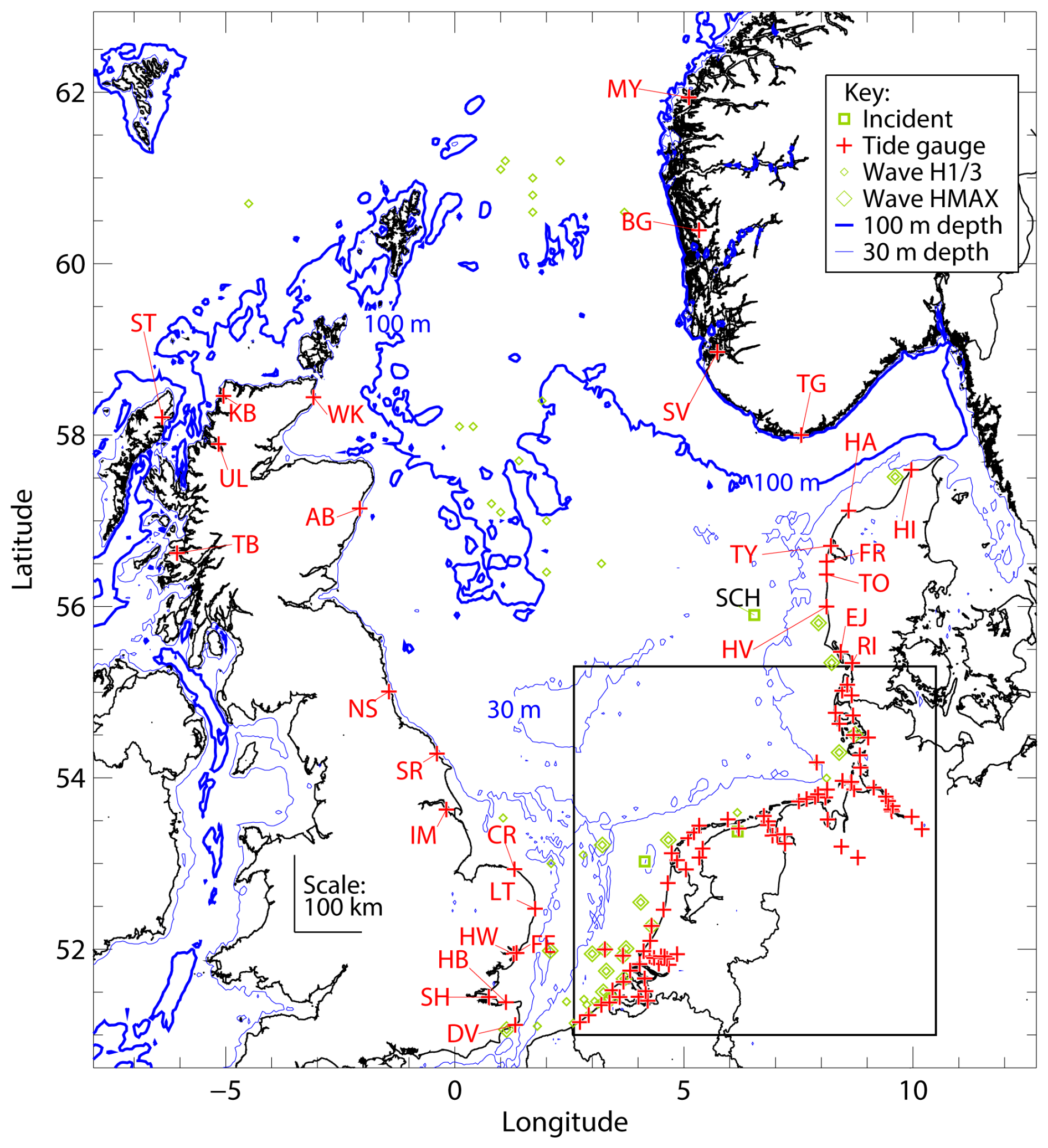
Figure 3Location of tide gauges analyzed in this study and of North Sea maritime accidents that were reported over the 2 d period 8–9 January 2005. For presentation clarity, the information in the inset box covering the south-eastern North Sea is shown in Fig. 4. The abbreviation codes for the tide gauges and maritime accidents are explained in Tables S2 and S4.
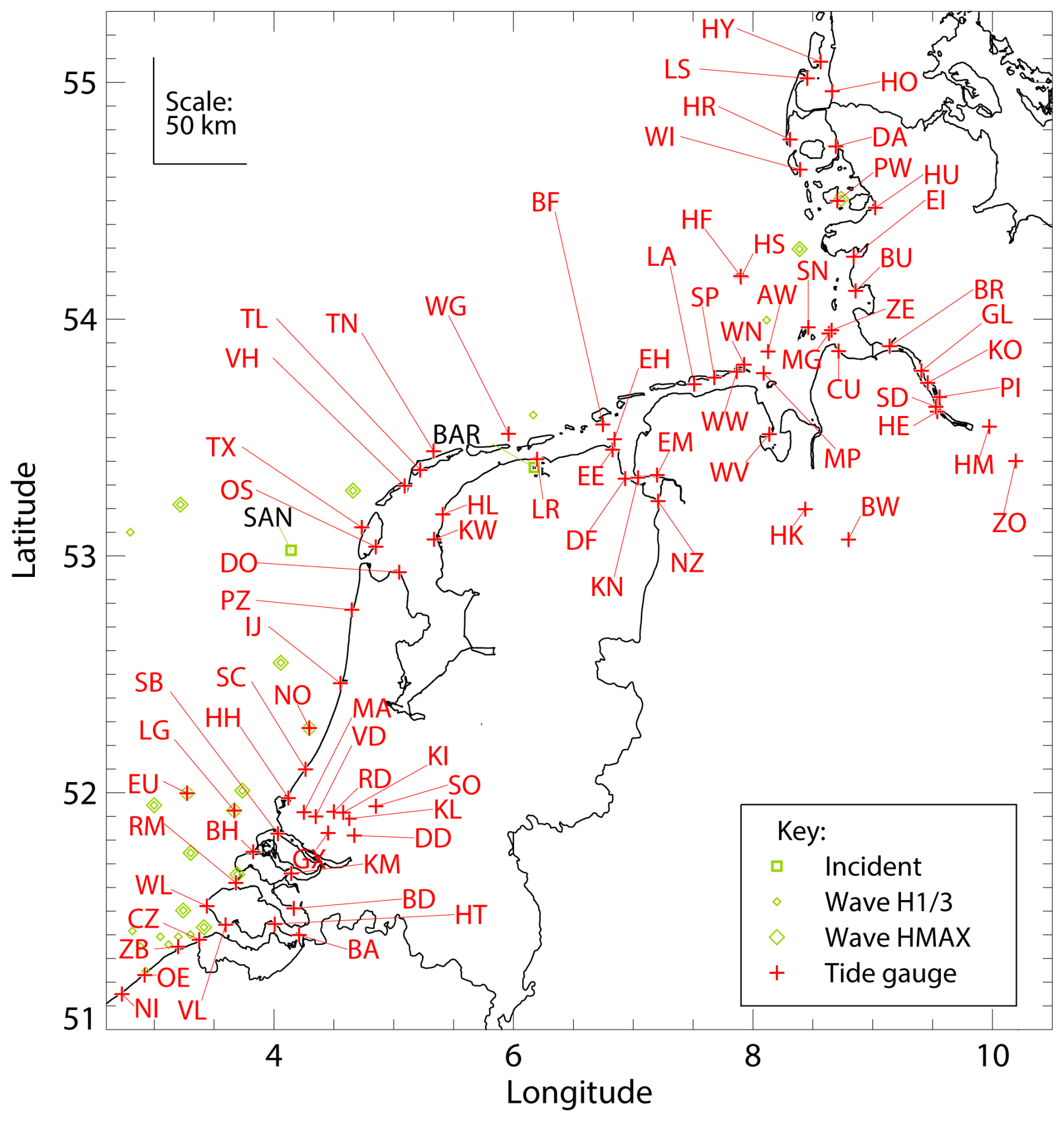
Figure 4Location of tide gauges and maritime accidents along the North Sea coasts of Belgium, the Netherlands, Germany, and southern Denmark. The abbreviation codes for the tide gauges and maritime accidents are explained in Tables S2 and S4.
The data were subjected to a spectral deconvolution process, following the procedure used in previous studies (Kettle, 2018, 2019, 2020, 2021, 2023a, b, 2024). First, a 16 d data segment was extracted for each station between 6–21 January 2005 inclusive, and it includes Storm Erwin on 8–9 January 2005, plus other storms that took place on 11–13 January and 18 January 2005. The data discretization for the different national authorities was 5 min (Belgium), 10 min (the Netherlands, Denmark, Norway, and two NNRCMP stations in the UK), or 15 min (UK BODC stations). For Germany, the data were delivered with a time discretization of 1 min. This was averaged into 10 min segments, and an analysis was conducted of the range of values in the averaging interval to assess for high amplitude waves with periods less than 10 min (Figs. S43 and S44). The sea level research community often uses the “harmonic analysis” technique to interpret time gauge data, but its practical application of fitting a large database of tidal components to a measurement time series is sometimes difficult (Pugh, 1987). For the present analysis, a discrete Fourier transform was used (Stull, 1988; Gönnert et al., 2004). This is a robust time series analysis tool of general applicability, but it requires gap-free datasets, and it is computationally expensive, which limits the length of the time series data that can be processed. The discrete Fourier transform was used to translate the linearly-detrended time series data into the spectral domain. A spectral plot was generated (e.g., Fig. S45) and used to identify the spectral cut-off limits for the different water level components: “long period” (mostly storm surge), “short period” (mostly harbour seiche or meteotsunami), and “tidal” (diurnal plus semidiurnal, combined). The time series for different spectral bands were reconstructed from the full spectral information, applying a constant set of spectral thresholds (Stull, 1988), so that each measurement time series could be deconvolved into its three spectral components. A detided “surge” or “surge residual” was also calculated as the short period and long period components together, following the conventions of older studies (Pugh, 1987).
The threshold to isolate the short period component was selected as 2 h. Previous studies meteotsunami investigations used a larger threshold of 4.8 h (Monserrat et al., 2006; Pattiaratchi and Wijeratne, 2015; Kettle, 2024). However, recent studies have used a shorter spectral threshold of 2 h (Zemunik et al., 2021; Lewis et al., 2023), and this is more appropriate for tide gauge stations in the shallow North Sea, which have a greater contribution from higher tidal harmonics. There is also an issue of what amplitude threshold to use to identify a meteotsunami in the short period component that is isolated from a tide gauge record. In a study of meteotsunamis around the UK, Lewis et al. (2023) used a 20 cm amplitude threshold to identify meteotsunami events. The small magnitude of this threshold may conceal a serious threat of coastal flooding and wave run-up during severe storms. For example, the 20 cm oscillation signal in a tide gauge record of 15 min resolution may have been caused by a high amplitude seiche with a characteristic frequency of a few minutes. As well, Spencer et al. (2015) identified large differences in measured coastal flood levels at nearby locations during Storm Xaver in December 2013, which were due to wave run-up effects at exposed sites.
The tide gauge levelling issue outlined in the analysis of previous North Sea storms (Kettle, 2021, 2023a, b, 2024) was also identified in the present event. The problem stems from the fact that the average water level for the selected 16 d period is usually higher than the official reports of mean sea level, sometimes by 10s of centimeters. Belgium is an exception, and the calculated bias is close to 0 cm. For the UK, the reference level of Ordnance Datum Newlyn is based on extended sea level measurements at Newlyn in the early 20th century and transferred by survey levelling techniques to local tide gauge reference points across most of the country. However, it is a problematic reference datum because of sea level rise over the past century, and also because an error was identified in the survey levelling techniques that were meant to link the reference points of all the tide gauges (Penna et al., 2013). For other countries, the origin of the sea level offset bias is unclear, and it is larger than the documented seasonal variation of water level due to lower atmospheric pressures prevalent during the winter stormy season (Thompson, 1980). Station collections for each country tend to have a similar bias (Fig. S46), and the situation means that the literature reports of storm surge water levels from different countries are not automatically intercomparable. The spectral decomposition procedure described above overcomes the intercomparison problem between stations since the 16 d data segments are linearly detrended before the discrete Fourier analysis is conducted. Where the literature values are presented in comparison graphs, no corrections are applied in this study.
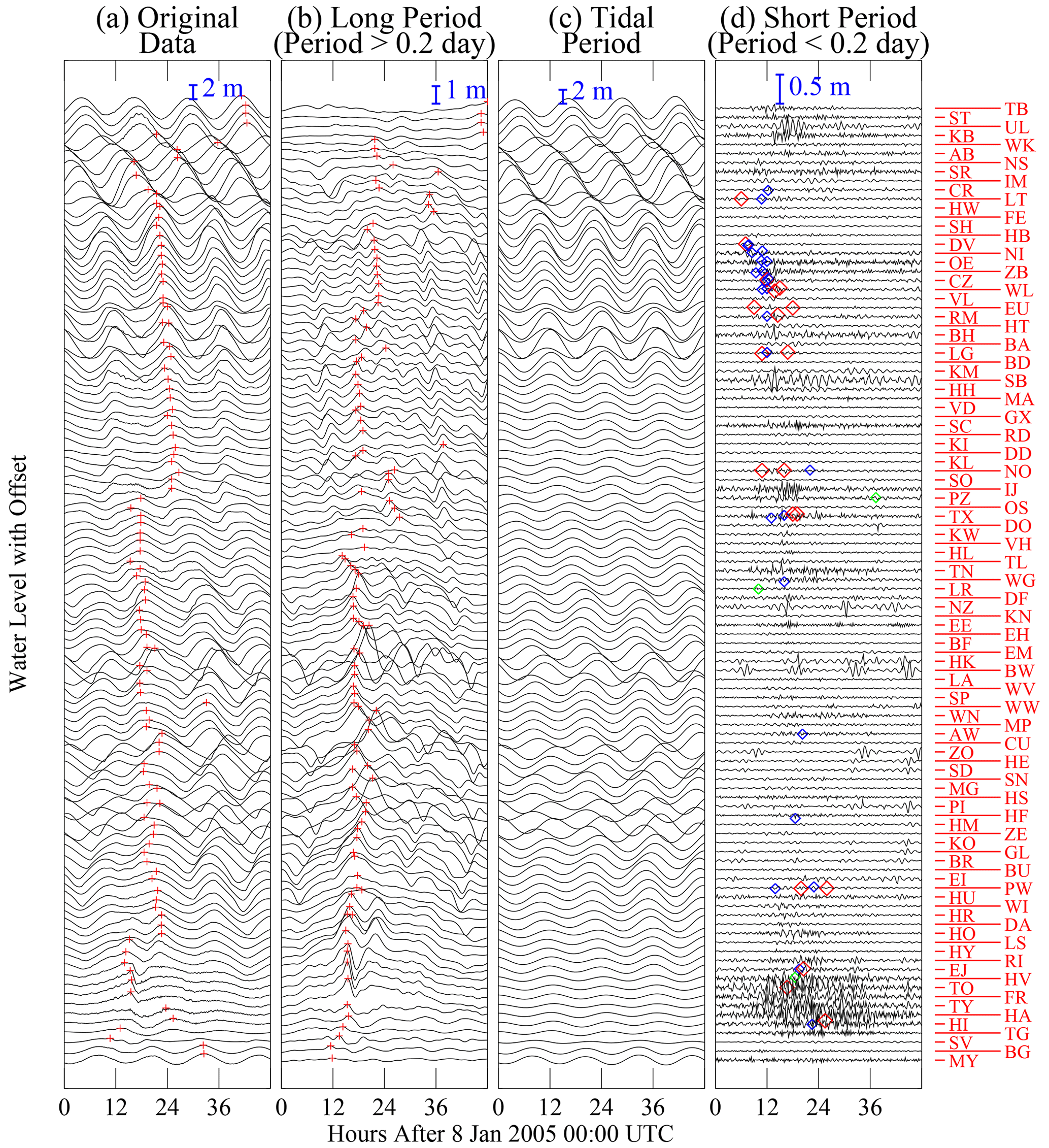
Figure 5Time series of the (a) original water level data, and reconstructions of the (b) long period, (c) diurnal plus semi-diurnal tide, and (d) short period components of the original time series. The station identifications are given by two letter codes along the right hand side of the fourth panel. The stations have been vertically offset according to their relative arrangement counter-clockwise around the North Sea, starting from Tobermory in Scotland at the top and ending with Maløy in Norway at the bottom. In the first two panels, red vertical crosses indicate the maximum of the data segment shown. In the last panel, diamonds mark the time of events at the closest tide gauge station: green for maritime accidents, blue for maximum significant wave height and red for maximum wave height.
A short database of maritime accidents in the North Sea area was compiled for the storm period 8–9 January 2005 to compare with the largest oscillations in the short period reconstruction of the water level time series. Shown in Table S4 and Fig. S47, two ship accidents were identified in Lloyd's Casualty Week (2005) and an additional record was identified from the call-out records of KNRM (Koninklijke Nederslandse Redding Maatschappij, or the Dutch lifeboat service). Additional comparison information was taken from the time series records of significant wave height and maximum wave height from different sources (Bidlot, J., email with wave measurement and ECMWF model data for Jan 2005, received on 15 December 2024; CEFAS, 2025; CMEMS, 2025; Kystdirektoratet, 2025; NNRCMP, 2025; RWS-Waterinfo, 2025; VLIZ, 2025). A database was compiled of the maximum values in the 2 d time series segment of the storm for the wave recorders that were within 150 km of a tide gauge (Tables S5 and S6). Wave recorders in the northern North Sea were beyond the selected 150 km threshold, and they were not linked to tide gauge events along the coastline.
The temporal characteristics of sea level variations around the North Sea during Storm Erwin are shown in Fig. 5. The first panel (Fig. 5a) shows the original time series data after being detrended. The following panels show the different components that have been isolated with the spectral filter: long period component (Fig. 5b), tidal component (diurnal plus semidiurnal; Fig. 5c), and high frequency component (Fig. 5d). The station data have been offset for visual clarity, and arranged according to counter-clockwise placement around the North Sea. This ordering has been chosen because the tides travel as coastally trapped Kelvin waves, passing counter-clockwise around the coastline of the UK, Belgium, the Netherlands, Germany, and Denmark in sequence. Some winter storms develop an external surge which travels in a similar manner as the tides, and whose progression around the basin can be traced from station to station.
The original time series data in Fig. 5a shows how the wave dynamics theory is manifested in real data. The water level is dominated by the semi-diurnal tide which shows small offsets from station to station while moving along the coast. It takes about 30 h to travel from the first station at Tobermory in Scotland to Maløy in Norway. The tidal component (semidiurnal plus diurnal) has been isolated in Fig. 5c, which shows it to be the largest component of the full time series. The second largest component of the water level time series is the long period component (Fig. 5b), which reveals the characteristics of the storm surge at different stations. The figure shows that the storm surge was limited mostly to the south-eastern and eastern parts of the North Sea, affecting coastal areas between the northern Netherlands and Denmark. Tide gauge stations along the west coast of Denmark show a double surge peak, and this has also been noted in a literature review (Nielsen, 2023). There was no literature report of an external surge propagating from Scotland during this storm. Rather, high surge water levels occurred at different locations in the eastern North Sea at about the same time. This was mostly due to the action of the west wind forcing water onto a lee shore, with a lesser contribution from the inverted barometer effect of sea level rise under a low pressure area.
The spatial and temporal characteristics of the surge are clarified in Figs. 6 and 7. The map in Fig. 6 shows the skew surge (i.e., the difference between the maximum water level and the nearest astronomical high tide) around the North Sea, illustrating that the largest values were along the western coast of Denmark, particularly near the border with Germany. Figure 7 shows the same skew surge information plotted against counter-clockwise distance around the North Sea, highlighting that the water levels reached up to 2.5 m above the expected high tide for one station on the Danish coast. The results of this analysis are plotted versus available literature data, showing good agreement in most cases. Figures S48 and S49 show the corresponding information for the surge residual, with heights that exceeded 2.5 m for several tide gauge stations in southern Denmark and in certain German North Sea estuaries.
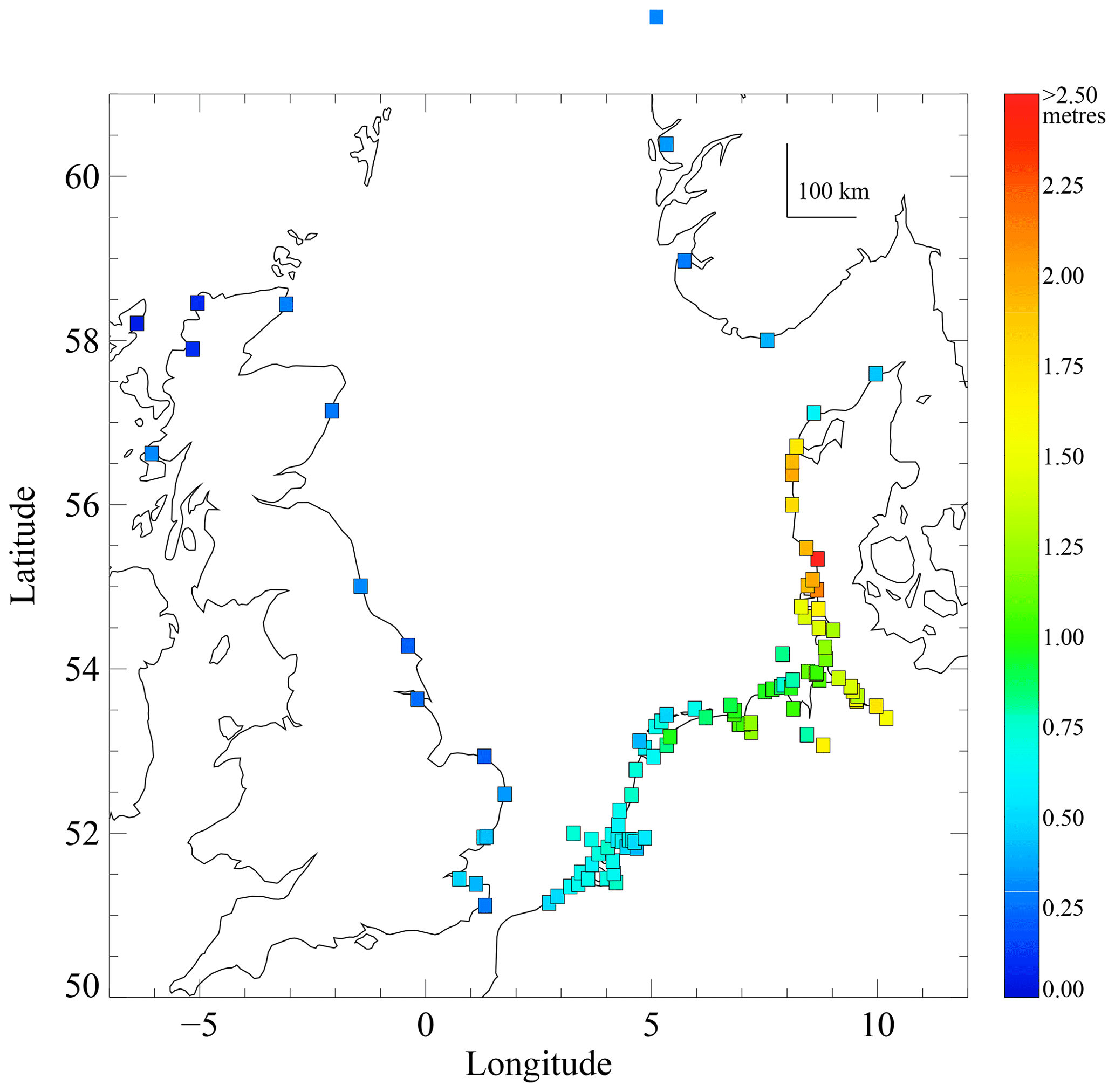
Figure 6Map of skew surge for tide gauge stations around the North Sea during Storm Erwin 8–9 January 2005.
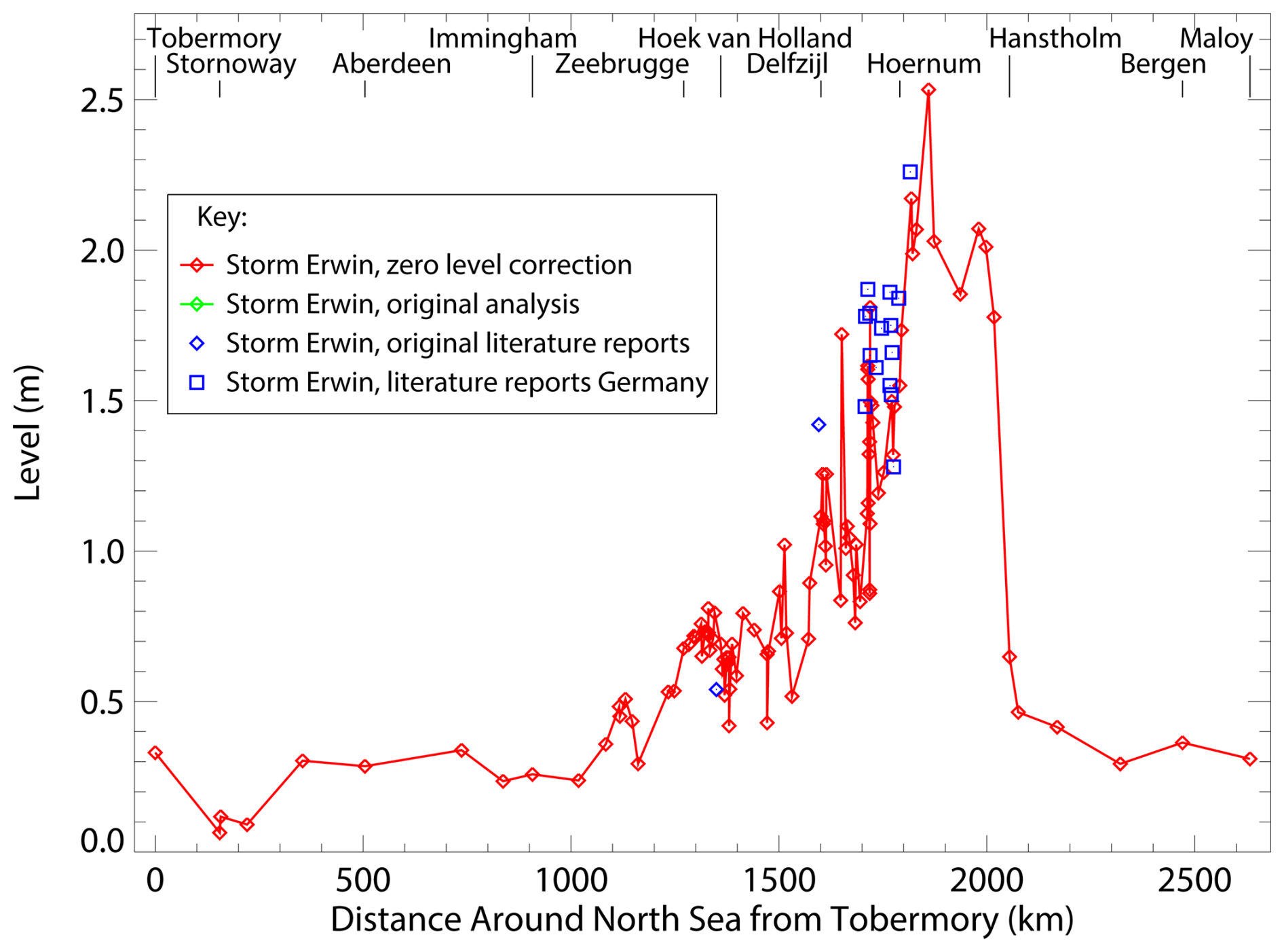
Figure 7Skew surge during storm Storm Erwin on 8–9 January 2005. The values are calculated from tide gauge records and arranged by counter-clockwise distance around the North Sea starting from Tobermory in Scotland. Literature reports are included for comparison.
To assess the significance of the water levels for this storm, the associated return periods have been plotted in Fig. 8, including areas on the Atlantic coast and especially the eastern Baltic Sea where the storm surge caused extensive flooding. Return periods are an important diagnostic to assess the significance of a storm surge, because different sections of coast in north-western Europe have different characteristic tidal variations, and the magnitudes of the longer period surges also vary spatially. For example, the Baltic Sea has low tidal amplitudes, while large tidal ranges (and large surges) occur in the German Bight. The return period information in Fig. 8 is derived from different literature sources and methods that are outlined in Table S7. Because the water levels at some locations were the highest in the instrument record, extrapolation methods based on extreme value theory are important to assess the return periods of this storm (e.g., Ditlevsen et al., 2018). The results suggest that the return periods at certain locations exceeded 400 years, which would have made Storm Erwin comparable to another record-breaking storm: Storm Xaver in 2013 (Wadey et al., 2015; Kettle, 2020). The highest return periods correspond to media reports of coastal flooding for Løgstør in Limfjord in Denmark (Beredeskapstyrelsen, 2005; DMI, 2005) and coastal locations in Finland and Estonia (Palginõmm et al., 2018). In spite of the high water level return period at Ringhals in Sweden, there were no reports of coastal flooding at this location in the literature, and the problems with the nuclear power plant there were linked with high concentrations of sea salt aerosol on electricity distribution system. In the southern North Sea, storm surge water levels along the Netherlands coast were low, and did not exceed the threshold of a 1 year return period event, which was outlined in an abbreviated RWS (2005) information sheet.
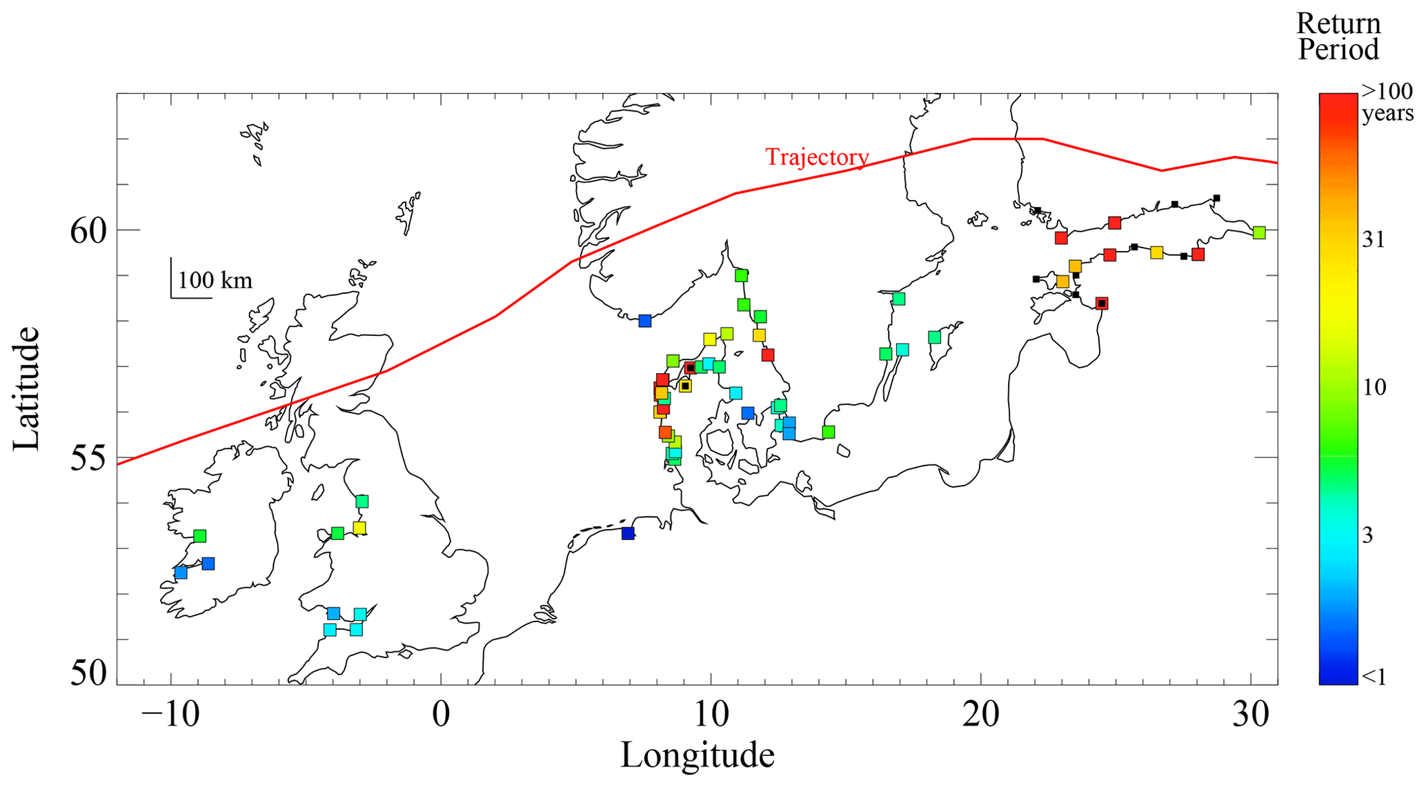
Figure 8Return period of maximum water level during Storm Erwin on 8–9 January 2005 from literature summary results. Small black squares indicate a literature report that the storm water level was the highest known event, without extra information to calculate a return period.
The time series of the short period component of the water level signal are shown in Fig. 5d along with extreme signals in nearby wave recorders and the three offshore accidents that were reported. An important centre of action appears to have been in northern Denmark during the first day of the storm. Here, several tide gauges registered large amplitude oscillations, and these occur in proximity with one of the ship accident reports and also with high wave values from several recorders. Across the North Sea on the Atlantic coast of Scotland, significant short period oscillations were registered at the near-lying stations of Ullapool and Kinlochbervie at approximately the same time as the Danish events on the afternoon of 8 January 2005. Along the coasts of Belgium and the Netherlands, many wave recorders registered their highest values at about the same time on 8 January 2005, but there was no clear linked anomaly in the short period component of the tide gauge signal. Likewise, it is difficult to discern an irregular pattern in the short period component of the tide gauge signal for the second maritime accident on 9 January 2005 off the coast of the Netherlands. Tables S8 and S9 give more information on the largest short period oscillation that occurred in each time series.
The spatial distribution of the highest amplitude short period features is shown on a map in Fig. 9. The largest short period features occurred in the northern section of the Danish west coast in the area of Limfjord. This was also the area where highest wind gusts in Europe were registered during the storm (Wikipedia, 2025), but is displaced from the area of highest skew surge, which was further to the south near the Danish-German border. There is a second cluster of large amplitude events in the southern part of the Netherlands, and the Ullapool site in northern Scotland also has a large amplitude event. Figure 10 shows a different projection of the maximum amplitude of short period oscillations versus counter-clockwise distance around the North Sea. It reveals how the short period maxima appeared to form a coherent feature across five tide gauge stations in northern Denmark covering about 150 km of coastline. The highest of these events exceeded the 20 cm amplitude threshold that was used by Lewis et al. (2023) to identify possible meteotsunamis around the UK. Although the timing of the highest short period amplitude events shows offsets (Table S8), consideration of the range information for the short period oscillations (Table S9) may indicate greater consistency with the event times, and it may be a better way to identify a potential meteotsunami. Expressed as the ratio of the maximum surge residual during the storm period, the maximum amplitude of the short period oscillations exceeded 0.6 for the highest instance at Ullapool in (Fig. S50), indicating the importance of the short period component of the water level record in certain instances.
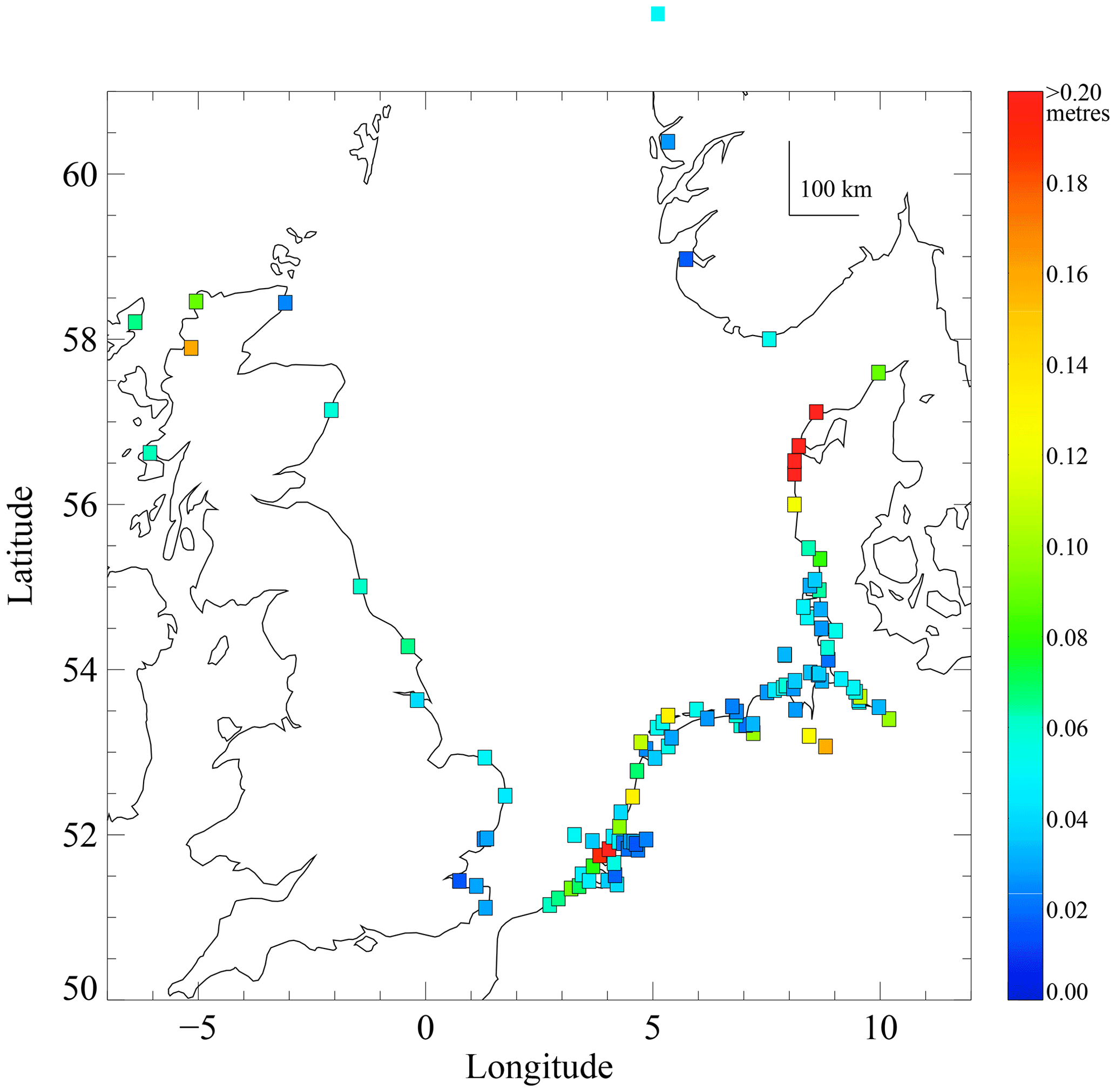
Figure 9Map of maximum amplitude of highest short period oscillation during Storm Erwin on 8–9 January 2005.
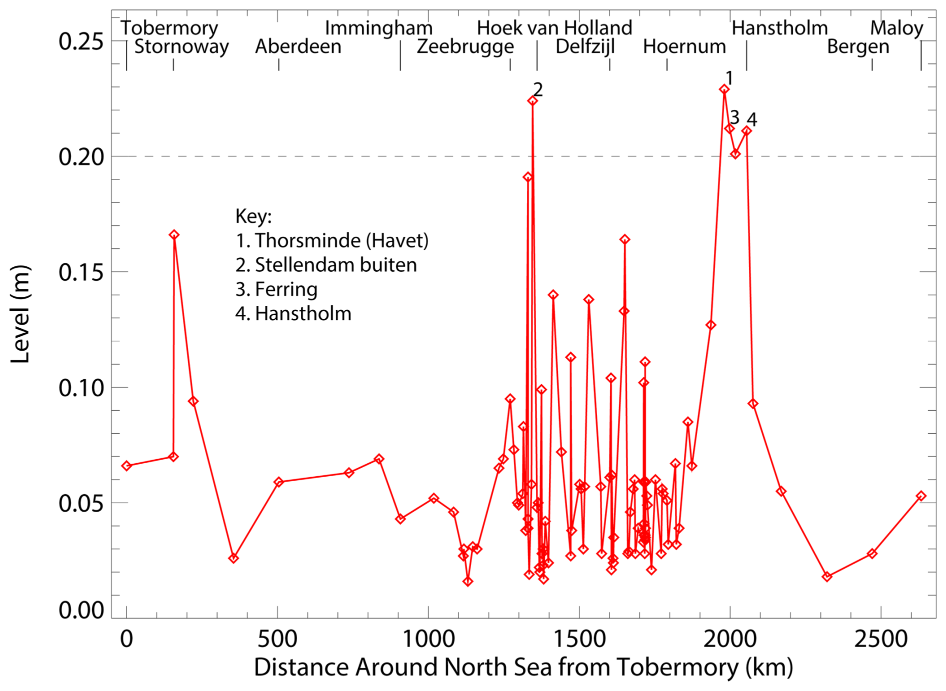
Figure 10Maximum amplitude of highest short period oscillation during Storm Erwin on 8–9 January 2005 versus coastal distance around the North Sea starting from Tobermory in Scotland. Selected outlier stations have been labelled. The horizontal dashed line marks the 20 cm threshold used by Lewis et al. (2023) to identify meteotsunamis in the UK tide gauge record.
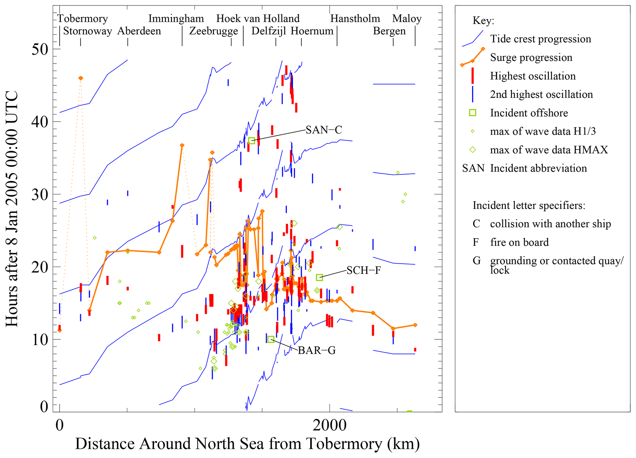
Figure 11Summary of the progression of the tidal crests and storm surge peak around the North Sea on 8–9 January 2005, and spatial–temporal relationship of peak-to-trough range of the highest up-crossing short period oscillations in the tide gauge record. Maritime accidents and the highest significant and maximum wave heights from recorders around the North Sea are also indicated. The data are plotted on axes of time versus counter-clockwise distance around the North Sea starting from Tobermory in Scotland. Maritime accidents are labelled with their three letter abbreviation if the uncertainty in the time of the event is less than 12 h.
Figure 11 summarizes all the information in this study on one set of axes of time versus counter-clockwise distance around the North Sea. (See also Figs. S51 and S52 simplified projections of this information.) This projection is effective in presenting the progression of the semidiurnal tidal peaks, which appear as diagonal lines on the plot. The travelling external surge was weak during this winter storm but does appear in association with the tide along the coasts of Scotland and eastern England as far south as Immingham. Otherwise, in the southern and eastern parts of the North Sea, there is little association between the surge peak and tides, and the surge maximum appears to be due to local wind effects along the coasts between the northern Netherlands and Denmark in the afternoon and early evening of 8 January 2005. In the German Bight, maxima of the tide and surge occur at about the same time. The highest short period oscillations occur in association with the surge along this section of coastline. Likewise, the maxima of the wave recorders for Germany and Denmark and two of the offshore maritime accidents appear within the cluster of events. A second cluster of events appears on the second day of the storm in the early afternoon of 9 January 2005. This is defined mainly by high values of the short period component of the tide data among a series of neighbouring tide gauge stations along the coasts of Belgium and the Netherlands over 12 h after the surge peak. The third offshore maritime accident plots within this cluster near the Netherlands coast.
Analysis conducted in the aftermath of Storm Erwin highlighted its extreme impact for certain regions. The worst impacts were in Sweden where the amount of forest damage was linked to the degree of destruction of the electrical distribution network. The forest damage in southern Sweden was unprecedented and was equivalent to the cumulative forest damage for all other winter storms over the preceding 100 years (Alexandersson and Ivarsson, 2005). The number of fallen trees was at the level of the country's timber production for one year, and the recovery of the fallen timber from the forests took about a year, requiring the assistance of a work force engaged from abroad. The recovered timber took about 5 years to process, during which time it was stored on the runway of a disused air base, becoming the largest timber storage depot in Europe. The hazards of forest clearance work were highlighted by fact that the final death toll in Sweden was about double the number of fatalities reported during the storm (Expressen, 2017; BioEnergy International, 2025). While interruptions to Sweden's nuclear power plants lasted only 1 d, the damage to the electricity distribution network in southern Sweden was severe and unprecedented in any previous storm. Electricity was restored slowly with the final customers back on the electricity network after a delay of seven weeks (Johansson et al., 2006; Rantanen, 2008). While most transportation interruptions in Europe were cleared soon after the storm, the train link between Stockholm and Malmö in the southwest was down for two weeks.
The large damage in eastern Baltic during Storm Erwin was associated more with the extraordinary storm surge especially in Finland and Estonia, though high winds also caused damage across the region. Because the storm surge was unprecedented in the measurement record for many locations, it led to the revision of building standards to address rare flood events (Haanpää et al., 2006; Suursaar and Sooäär, 2006), as well as research efforts to identify the worst case storm flood levels (Suursaar et al., 2006; Averkiev and Klevannyy, 2010). Modelling studies revealed that local flood levels depended on the propagation speed and direction of the cyclone centre as well as its distance from the affected area. Although flood levels were bad at some locations in the eastern Baltic Sea, higher flood levels were possible (Averkiev and Klevannyy, 2010). For other countries in Europe, the storm damage was serious but mostly not unprecedented. In Denmark, for example, the forest damage and number of fatalities during Storm Erwin were about half of the level of Storm Anatol in December 1999 (Beredskabstyrelsen, 2005). Storm Erwin caused extensive power outages Denmark, mostly due to damage of the exposed network of power lines in the country. Denmark was already in the process of transferring its power distribution network underground after Storm Anatol in 1999 (Beredeskapstyrelsen, 2005; Danish Energy Agency, 2016), and Sweden would pursue a similar policy of buried transmission cables in rebuilding its electricity transmission network after the storm (Johansson et al., 2006; Bioenergy International, 2025; Myhr, 2025). In spite of the impacts on power infrastructure onshore, energy infrastructure offshore – particularly the new large-scale offshore wind energy projects – was less affected, possibly due to the nature of warm westerly wind field. The North Sea wave field during Storm Erwin was not as dangerous as during Storm Britta on 1 November 2006, but there was a growing realization of the threat of increasingly powerful storms to offshore wind energy and petroleum infrastructure in Europe (Petroleum Safety Authority, 2006, 2007; Pleskachevsky et al., 2012).
The water level data for this study were measured by the national tide gauge networks of the UK, Belgium, the Netherlands, Germany, Denmark, and Norway. They have mostly been downloaded from public websites: BODC (2025), Kartverket (2025), Kystdirektoratet (2025), NNRCMP (2025), RWS-Waterinfo (2025), and VLIZ (2025). Other datasets were obtained by email contact: Frederiksen (personal communication, 2023), Matthews (personal communication, 2023), Warwick-Champion (personal communication, 2024), and Wiechman (personal communication, 2024).
The supplement related to this article is available online at https://doi.org/10.5194/adgeo-67-101-2025-supplement.
The author has declared that there are no competing interests.
This article is part of the special issue “European Geosciences Union General Assembly 2025, EGU Division Energy, Resources & Environment (ERE)”. It is a result of the EGU General Assembly 2025, Vienna, Austria & Online, 27 April–2 May 2025.
Publisher's note: Copernicus Publications remains neutral with regard to jurisdictional claims made in the text, published maps, institutional affiliations, or any other geographical representation in this paper. While Copernicus Publications makes every effort to include appropriate place names, the final responsibility lies with the authors. Views expressed in the text are those of the authors and do not necessarily reflect the views of the publisher.
The author gratefully acknowledges data from tide gauge networks of the UK, Belgium, the Netherlands, Germany, Denmark, and Norway. For Germany, Wilfried Wiechmann of the Bundesanstalt für Gewässerkunde kindly emailed time series data of high water and low water values for Germany North Sea stations. Bjørn Frederiksen (Kystdirektoratet, Denmark) emailed data for two tide gauge stations (Hansthom and Hirtshal) in northern Denmark that were not provided on the public Internet server. Elizabeth Warwick-Champion (Channel Coastal Observatory, National Oceanography Centre, UK) emailed data for the Scarborough tide gauge, and Robin Matthews (Environment Agency, UK) emailed data from the Southend tide gauge. The following people provided background reports, data, or other information to support this review: Jean Bidlot (European Centre for Medium Range Weather Forecasts), Maria Blümel, Hauke Thiesen and Theide-Erk Woeffler (Landesbetrieb für Küstenschutz, Nationalpark, und Meereschutz Schleswig-Holstein, Germany), Ramona Carr (Marine Institute, Ireland), Tom Hull (CEFAS, UK), Jonas Johansson (Lund University), Ola Kalén (Swedish Meteorological and Hydrological Institute, Sweden), Peter Newport (Office of Public Works, Ireland), Irene Perez-Gonzalez (Bundesamt für Seeschifffahrt und Hydrographie, Germany), Reidun Gangstø Skaland (met.no), and Kari Turøy (Havindustritilsynet). The manuscript was improved by the reviews of Philip Woodworth and one anonymous referee. The author is grateful for publication support by the editor, Michael Kühn.
This paper was edited by Michael Kühn and reviewed by Philip Woodworth and one anonymous referee.
Alexandersson, H. and Ivarsson, K. I.: Januaristormen 2005, Faktablad no. 25, SMHI, https://www.smhi.se/download/18.18f5a56618fc9f08e832d664/1717805946933/faktablad_janstorm%5B1%5D.pdf (last access: 21 November 2025), 2005.
Angus, S. and Rennie, A.: An Ataireachd Aird: The storm of January 2005 in the Uists, Scotland, Ocean Coast. Manage., 94, 22–29, 2014.
Argyriadis, K., Fischer, G., Frohböse, P., Kindler, D., and Reher, F.: Research platform FINO1 – Some measurement results, in: Volume 2, European Wind Energy Conference EWEC and Exhibition 2006, 27 February–2 March 2006, Athens, Greece, 906–915, ISBN 978-1-62276-467-9, 2006.
Averkiev, A. S. and Klevannyy, K. A.: A case study of the impact of cyclonic trajectories on sea-level extremes in the Gulf of Finland, Cont. Shelf Res., 30, 707–714, 2010.
Baker, L.: Sting jets in severe northern European wind storms, Weather, 64, 143–148, 2009.
Bancroft, G. P.: Marine Weather Review – North Atlantic Area, January through April 2005, vol. 49, Mariners Weather Log, https://www.vos.noaa.gov/MWL/aug_05/north_atlantic.shtml (last access: 21 November 2025), 2005.
BBC: Northern Europe shaken by storms, http://news.bbc.co.uk/2/hi/europe/4158809.stm (last access: 21 November 2025), 2005.
Beredskabstyrelsen: Beredskabets indsats i forbindelse med orkanen 8. januar 2005, En tvaergaende erfaringsopsamling, Datavej16, 3460 Birkerød, https://www.brs.dk/globalassets/brs---beredskabsstyrelsen/dokumenter/krisestyring-og-beredskabsplanlagning/2020/-orkanrapport_8januar2005-.pdf (last access: 21 November 2025), 2005.
Bioenergy International: The aftermath and legacy of Storm Gudrun – 20 years on (contributor Alan Sherrard), https://bioenergyinternational.com/the-aftermath-and-legacy-of-storm-gudrun-20-years-on/ (last access: 21 November 2025), 2025.
BODC: UK tide gauge download site, https://www.bodc.ac.uk/data/hosted_data_systems/sea_level/uk_tide_gauge_network/processed/ (last access: 21 November 2025), 2025.
CEFAS: Wavenet, https://wavenet.cefas.co.uk/ (last access: 9 June 2025), 2025.
Clark, P. A. and Gray, S. L.: Sting jets in extratropical cyclones: a review, Q. J. Roy. Meteorol. Soc., 144, 943–969, 2018.
ClimateChangePost: Denmark Storms, https://www.climatechangepost.com/countries/denmark/storms/ (last access: 24 November 2024), 2024.
CMEMS: Copernicus Marine Service In-Situ Ocean TAC, http://marineinsitu.eu/dashboard/ (last access: 9 June 2025), 2025.
Danish Energy Agency: Security of Electricity Supply in Denmark, in: 1st edition 2015, translated Danish Energy Agency, Copenhagen K, ISBN 978-87-93180-15-4, 2016.
Danish Energy Authority: Offshore Wind Power, Danish Experiences and Solutions, Danish Energy Authority, https://www.ft.dk/samling/20051/almdel/epu/bilag/37/213664.pdf (last access: 21 November 2025), 2005.
Dawson, A. G., Dawson, S., and Ritchie, W.: Historical climatology and coastal change associated with the `Great Storm' of January 2005, South Uist and Benbecula, Scottish Outer Hebrides, Scott. Geogr. J., 123, 135–149, 2007.
Deutsche Rück: Sturmdokumentation Deutschland 2005 (contributors: T. Axer, T. Bistry, S. Fietze, M. Müller, M. Prechtl), Deutsche Rückversicherung, Aktiengesellschaft, Düsseldorf, https://www.deutscherueck.de/fileadmin/Downloads/Sturmdoku_2005_web.pdf (last access: 21 November 2025), 2006.
Ditlevsen, C., Ramos, M. M., Sørensen, C., Ciocan, U. R., and Pionkowitz, T.: Højvandsstatistikker 2017, Miljo- og Fødevareministeriet, Kystdirektoratet Lemvig, https://kyst.dk/media/bizn2o4z/hoejvandsstatistikker2017revideret11022019.pdf (last access: 21 November 2025), 2018.
DMI: Danmark ramt af landsdækkende storm, https://www.dmi.dk/nyheder/2005/danmark-ramt-af-landsdakkende-storm#:~:text=Stormen (last access: 21 November 2025), 2005.
Emeis, S. and Türk, M.: Wind-driven wave heights in the German Bight, Ocean Dynam., 59, 463–475, 2009.
ESWD: European Severe Weather Database, 7–9 January 2005, https://eswd.eu (last access: 3 August 2024), 2024.
Expressen: Gudrun 2005: 20 doedas i den vaarsta storm, https://www.expressen.se/nyheter/inloggad/gudrun-2005-20-dodas-i-den-varsta-stormen/ (last access: 21 November 2025), 2017.
Fore, A. G., Stiles, B. W., Chau, A. H., Williams, B. A., Dunbar, R. S., and Rodriguez, E.: Point-wise wind retrieval and ambiguity removal improvements for the QuikSCAT climatological data set, IEEE T. Geosci. Remote, 52, 51–59, https://doi.org/10.1109/TGRS.2012.2235843, 2014.
Gönnert, G., Isert, K., Giese, H., and Plüss, A.: Charakterisierung der Tidekurve, Küste, 68, 99–141, 2004.
Guardian: Thousands lose power in storms (contributor Henry McDonald), https://www.theguardian.com/environment/2005/jan/09/weather.theobserver1 (last access: 21 November 2025), 2005.
Guy Carpenter: Windstorm Erwin/Gudrun – January 2005, Specialty Practice Briefing, https://www.dmi.dk/fileadmin/user_upload/Bruger_upload/Nyhed/2005/8januarstormguycarprapport.pdf (21 November 2025), 2005.
Haanpää, S., Lehtonen, S., Peltonen, L., and Talockaite, E.: Impacts of winter storm Gudrun of 7th–9th January 2005 and measures taken in the Baltic Sea region, Astra, 43 pp., 2006.
Hallands Nyheder: Stormen staengde Ringhals (contributor Krister Svahn), https://www.hn.se/nyheter/varberg/stormen-stangde-ringhals.036d8cf7-2756-4206-b13c-6d03f504a264 (last access: 21 November 2025), 2005.
Hellenberg, T. and Kentala, J.: Chapter III. Sudden sea level rise in the Gulf of Finland in January 2005, in: Early Warning and Civil Protection. When does it work and why does it fail?, edited by: Pursiainen, C., Nordregio report 2008:1, Nordregio, https://www.diva-portal.org/smash/get/diva2:700398/FULLTEXT01.pdf (last access: 21 November 2025), 2008.
Hisscott, A.: When NWP met climatology: storms over the Isle of Man during January 2005, Weather, 62, 74–77, 2007.
Irish Times: Seven die as storm hits southern Scandinavia, https://www.irishtimes.com/news/seven-die-as-storm-hits-southern-scandinavia-1.1295791 (last access: 21 November 2025), 2005.
Johansson, J., Lindahl, S., Samuelsson, O., and Ottoson, H.: The storm Gudrun. A seven-week power outage in Sweden, CRIS, in: Third International Conference on Critical Infrastructure, September 2006, Alexandria, Virginia, https://portal.research.lu.se/en/publications/the-storm-gudrun-a-seven-weeks-power-outage-in-sweden/ (last access: 28 April 2025), 2006.
Johns, R. H., Davies, J. M., and Leftwich, P. W.: Some wind and instability parameters associated with strong and violent tornadoes. 2. Variations in the combinations of wind and instability parameters, in: The Tornado: Its Structure, Dynamics, Prediction, and Hazards, Geophysical Monograph 79, edited by: Church, C., American Geophysical Union, Washington, D.C., 583–590, https://prod-east-spc.woc.noaa.gov/publications/johns/torparms.pdf (last access: 1 November 2024), 1993.
Kartverket: Se havnivå, https://www.kartverket.no/til-sjos/se-havniva (last access: 8 June 2025), 2025.
Kettle, A. J.: The North Sea surge of 31 October–1 November 2006 during Storm Britta, Adv. Geosci., 45, 273–279, https://doi.org/10.5194/adgeo-45-273-2018, 2018.
Kettle, A. J.: Storm Tilo over Europe in November 2007: storm surge and impacts on societal and energy infrastructure, Adv. Geosci., 49, 187–196, https://doi.org/10.5194/adgeo-49-187-2019, 2019.
Kettle, A. J.: Storm Xaver over Europe in December 2013: Overview of energy impacts and North Sea events, Adv. Geosci., 54, 137–147, https://doi.org/10.5194/adgeo-54-137-2020, 2020.
Kettle, A. J.: Storm Anatol over Europe in December 1999: impacts on societal and energy infrastructure, Adv. Geosci., 56, 141–153, https://doi.org/10.5194/adgeo-56-141-2021, 2021.
Kettle, A. J.: Storm Kyrill and the storms of mid-January 2007: Societal and Energy Impacts in Europe, Adv. Geosci., 58, 135–147, https://doi.org/10.5194/adgeo-58-135-2023, 2023a.
Kettle, A. J.: Storm Franz: Societal and energy impacts in northwest Europe on 11–12 January 2007, Adv. Geosci., 62, 41–55, https://doi.org/10.5194/adgeo-62-41-2023, 2023b.
Kettle, A. J.: Storm Daria: Societal and energy impacts in northwest Europe on 25–26 January 1990, Adv. Geosci., 65, 83–101, https://doi.org/10.5194/adgeo-65-83-2024, 2024.
Klee, I. and Noren, L. (Eds.): Annual Report 2005, Nordel Secretariat, Helsinki, Finland, 21 January 2005, http://www.pfbach.dk/firma_pfb/historien/data_files/Nordel_ann_2005.pdf (last access: 8 October 2025), 2006.
Krzystyniak, M.: The relationship between extreme weather events and subsequent slide events in Norway, Master Thesis, Dept. of Geosciences, University of Oslo, Oslo, https://dissertation.com/abstract/1277924 (last access: 28 April 2025), 2011.
Kystdirektoratet: Vandstandsmålinger, https://kyst.dk/soeterritoriet/maalinger-og-data/vandstandsmaalinger/ (last access: 7 June 2025), 2025.
Lewis, C., Smyth, T., Williams, D., Neumann, J., and Cloke, H.: Meteotsunami in the United Kingdom: the hidden hazard, Nat. Hazards Earth Syst. Sci., 23, 2531–2546, https://doi.org/10.5194/nhess-23-2531-2023, 2023.
Lloyds Casualty Week: Lloyd's MIU, Telephone House, London, https://dione.lib.unipi.gr/xmlui/bitstream/handle/unipi/1808/Casualty_Week_Jan_21.pdf?sequence=3&isAllowed=y (last access: 21 November 2025), 2005.
Magnusson, A. K.: Powerpoint presentation at the EXWW work meeting 2006–2007 Hotel Admiral, 12–14 June 2007, Bergen, https://www.slideserve.com/liluye/exww-workmeeting-2006-2007-hotel-admiral-bergen-june-12-14th-2007-presentations-by-met-no (last access: 21 November 2025), 2007.
Magnusson, A. K.: What is true sea state? Powerpoint presentation at the 11th International Workshop on Wave Hindcasting and Forecasting and Coastal Hazard Symposium, JCOMM, 18–23 October 2009, Halifax, Canada, http://www.waveworkshop.org/11thWaves/ProgramFrameset.htm (last access: 21 November 2025), 2009.
Meland, T.: Production shut down, https://draugen.industriminne.no/en/2018/08/08/production-shut-down/, (last access: 22 November 2025), 8 August 2018.
Miller, R. C.: Notes on analysis and severe-storm forecasting procedures of the Air Force Global Weather Central, Technical Report 200 (Rev), Air Weather Service (MAC), United States Air Force, 184 pp., https://apps.dtic.mil/sti/tr/pdf/AD0744042.pdf (last access: 1 November 2024), 1972.
MIROS: Ekofisk Monthly Report, November 2007, Doc No. ND/1024/05/01, MIROS, 29 pp., 2005.
Monserrat, S., Vilibić, I., and Rabinovich, A. B.: Meteotsunamis: atmospherically induced destructive ocean waves in the tsunami frequency band, Nat. Hazards Earth Syst. Sci., 6, 1035–1051, https://doi.org/10.5194/nhess-6-1035-2006, 2006.
Myhr, K. J.: Storm puts focus on security, https://history.vattenfall.com/stories/power-to-the-people/storm-puts-focus-on-security/ (last access: 24 January 2025), 2025.
Nielsen, J. W.: Stormfloden den 8. januar 2005, https://ocean.dmi.dk/case_studies/surges/2005-01-08.php (last access: 21 February 2023), 2023.
NNRCMP: National Network of Regional Coastal Monitoring Programmes, https://coastalmonitoring.org/ (last access: 9 June 2025), 2025.
NRK: Gudrun herjar i sor (contributor Bent J. Tandstad), https://www.nrk.no/norge/_gudrun_-herjar-i-sor-1.514801 (last access: 21 November 2025), 2005.
Palginõmm, V., Orviku, K., Suursaar, Ü., Kont, A., Tõnisson, H., and Rivis, R.: Lessons learned from record-high storm surges and associated inundations in Pärnu, SW Estonia, J. Coast. Res., 85, 1–5, 2018.
Pattiaratchi, C. B. and Wijeratne, E. M. S.: Are meteotsunamis an underrated hazard?, Philos. T. Roy. Soc. A, 373, 2140377, https://doi.org/10.1098/rsta.2014.0377, 2015.
Pellikka, H., Rauhala, J., Kahma, K. K., Stipa, T., Boman, H., and Kangas, A.: Recent observations of meteotsunamis on the Finnish coast, Nat. Hazards, 74, 197–215, 2014.
Penna, N. T., Featherstone, W. E., Gazeaux, J., and Bingham, R. J.: The apparent British sea slope is caused by systematic errors in the levelling-based vertical datum, Geophys. J. Int., 194, 772–786, 2013.
Petroleum Safety Authority Norway: Annual Report 2005, Stavanger, 2005.
Petroleum Safety Authority Norway: Annual Report 2006, Supervision and facts, Stavanger, 2007.
Piontkowitz, T. and Sørensen, C.: Consequences of Climate Change along the Danish Coasts, Safecoast Action 5A, Danish Coastal Authority, Lemvig, Denmark, 2008.
Pleskachevsky, A. L., Lehner, S., and Rosenthal, W.: Storm observations by remote sensing and influences of gustiness on ocean waves and on generation of rogue waves, Ocean Dynam., 62, 1335–1351, https://doi.org/10.1007/s10236-012-0567-z, 2012.
PO.DAAC: QuikSCAT Level 2B Version 3, Guide Document, 7 March 2013, Version 1.0, PO.DAAC – Physical Oceanography Distributed Active Archive Centre, https://podaac.jpl.nasa.gov/dataset/QSCAT_LEVEL_2B_OWV_COMP_12 (last access: 21 November 2025), 2013.
PO.DAAC: QuikSCAT Level 2B Ocean Wind Vectors in 12.5km Slice Composites Version 3 (QSCAT_LEVEL_2B_OWV_COMP_12), https://podaac.jpl.nasa.gov/dataset/QSCAT_LEVEL_2B_OWV_COMP_12 (last access: 7 June 2025), 2025.
Pugh, D. T.: Tides, Surges and Mean Sea Level, John Wiley and Sons, ISBN 047191505X, https://eprints.soton.ac.uk/19157/1/sea-level.pdf (last access: 22 November 2025), 1987.
Rantanen, H.: Chapter IV. Coping with Power Disturbance, in: Early Warning and Civil Protection. When does it work and why does it fail?, edited by: Pursiainen, C., Nordregio report 2008: 1, Nordregio, 95–119, https://www.diva-portal.org/smash/get/diva2:700398/FULLTEXT01.pdf (last access: 21 November 2025), 2008.
Roberts, J. F., Champion, A. J., Dawkins, L. C., Hodges, K. I., Shaffrey, L. C., Stephenson, D. B., Stringer, M. A., Thornton, H. E., and Youngman, D. B.: The XWS open access catalogue of extreme European windstorms from 1979 to 2012, Nat. Hazards Earth Syst. Sci, 14, 2487–2501, https://doi.org/10.5194/nhess-14-2487-2014, 2014.
RWS: Stormvloedflits 2005-02. Zeer zware zuidwesterstorm veroorzaakt vrij hoge waterstanden langs de kust (contributor Jan Kroos), https://open.rijkswaterstaat.nl/open-overheid/onderzoeksrapporten/@257045/stormvloedflitsen-wmcn-kust/ (last access: 21 November 2025), 2005.
RWS-Waterinfo: Rijkswaterstaat Waterinfo, https://waterinfo.rws.nl/ (last access: 9 June 2025), 2025.
Sanders, F. and Gyakum, J. R.: Synoptic-dynamic climatology of the `Bomb', Mon. Weather Rev., 108, 1589–1606, https://doi.org/10.1175/1520-0493(1980)108<1589:SDCOT>2.0.CO;2, 1980.
Šepić J., Vilibić, I., Rabinovich, A. B., and Montserrat, S.: Widespread tsunami-like waves of 23–27 June in the Mediterranean and Black Seas generated by high altitude atmospheric forcing, Sci. Rep., 5, 11682, https://doi.org/10.1038/srep11682, 2015.
Spencer, T., Brooks, S. M., Evans, B. R., Tempest, J. A., and Moeller, I.: Southern North Sea storm surge event of Dec. 5, 2013: Water levels, waves, and coastal impacts, Earth-Sci. Rev., 146, 120–145, 2015.
Stull, R. B.: An Introduction to Boundary Layer Meteorology, Kluwer Academic Publishers, Dordrecht, ISBN 978-90-277-2769-5, ISBN 978-90-277-2768-8, 1988.
Suursaar, Ü. and Sooäär, J.: Storm surge induced by extratropical cyclone Gudrun: hydrodynamic reconstruction of the event, assessment of mitigation actions and analysis of future flood risks in Pärnu, Estonia, in: WIT Transactions on Ecology and the Environment, vol. 91, WIT Press, 241–250, ISSN 1743-3541, https://doi.org/10.2495/RISK060231, 2006.
Suursaar, Ü., Kullas, T., Otsmann, M., Saarmäe, I., Kuik, J., and Merilain, M.: Cyclone Gudrun in January 2005 and modelling its hydrodyanamic consequences in the Estonian coastal waters, Boreal Environ. Res., 11, 143–159, 2006.
Thompson, K. R.: An analysis of British monthly sea level, Geophys. J. Res. Astron. Soc., 63, 57–73, 1980.
University of Wyoming: Atmospheric Science Radiosonde Archive, https://weather.uwyo.edu/upperair/sounding_legacy.html (last access: 7 June 2025), 2024.
US Army Corps of Engineers: Shore Protection Manual, Volume 1, Coastal Engineering Research Center, Department of the Army, Waterways Experiment Station, Corps of Engineers, Vicksburg, Mississippi, USA, https://www.ancientportsantiques.com/wp-content/uploads/Documents/ENGINEERING/Maritime/ShoreProtectionManual-Vol1-1984.pdf (last access: 22 November 2025, 1984.
VLIZ: Belgium tide gauge and wave data, https://meetnetvlaamsebanken.be (last access: 8 June 2025), 2025.
Wadey, M. P., Haigh, I. D., Nichols, R. J., Brown, J. M., Horsburgh, K., Carroll, B., Gallop, S. L., Mason, T., and Bradshaw, E.: A comparison of the 31 January–1 February 1953 and 5–6 December 2013 coastal flood events around the UK, UK Front. Mar. Sci., 2, 84, https://doi.org/10.3389/fmars.2015.00084, 2015.
Wikipedia: Ekstremveret Gudrun, https://nn.wikipedia.org/wiki/Ekstremvêret_Gudrun (last access: 29 April 2025), 2025.
Wolf, J.: Modelling of waves and setup for the storm of 11–12 January 2005, report no. 181, Proudman Oceanographic Institute, https://nora.nerc.ac.uk/id/eprint/2672/1/POL_ID_181.pdf (last access: 22 November 2025), 2007.
XWS: Extreme Wind Storms Catalogue, https://www.europeanwindstorms.org/ (last access: 7 June 2025), 2025.
Zemunik, P., Šepić, J., Pellikka, H., Ćatipović, L., and Vilibić, I.: Minute Sea-Level Analysis (MISELA): a high frequency sea-level analysis global dataset, Earth Syst. Sci. Data, 13, 4121–4132, https://doi.org/10.5194/essd-13-4121-2021, 2021.