 | 24 Mar 2025
The ArtemIS project: Assessment for medium-depth geothermal energy utilization in Germany
Leandra M. Weydt
Thorsten Agemar
Michael Erb
Niklas Mantei
Nicole Dobrzinski
Josef Weber
Sebastian Sperlich
Jeroen van der Vaart
Kristian Bär
Inga Moeck
Ingo Sass
To date, most geothermal projects in Germany have focused on deep geothermal systems, while resources at intermediate depths have only been explored to a small extend. However, medium-depth geothermal systems have a high potential for heat generation, even in areas previously considered less favorable for deep geothermal energy, and could make a significant contribution to Germany's heat supply. To accelerate the heat transition and to become independent of fossil fuels, the ArtemIS project aims to assess the medium-depth geothermal systems in Germany, covering all types of geological plays and providing regional information for different geothermal applications. Interactive heat transition profiles are being developed containing all relevant subsurface information required for preliminary geothermal assessment, such as geological descriptions of potential geothermal reservoirs, reservoir thickness, hydraulic and thermal rock properties, and fluid chemistry. In addition, static 3D geological models are being created as the basis for 3D numerical reservoir models using COMSOL Multiphysics to simulate the regional heat potential and different geothermal scenarios, including the performance of hydrothermal doublets. The investigation of well logs and core sample data of the Upper Maastrichtian Calcarenites in the North German Basin indicates a good geothermal potential, but notable lateral and vertical heterogeneities regarding reservoir thickness, grain size or glauconite content throughout the study area need to be considered during exploration. The first COMSOL simulation results highlight the impact of inter-well distance and reservoir thickness on operational parameters such as the occurrence time of thermal breakthrough and cooling rate in a multi-well array. Likewise, a 3D structural model of the Upper Rhine Graben was created and used to assess the regional heat supply, indicating a high potential for heat production in the sedimentary units at intermediate depths. The results of the ArtemIS project will be integrated into the publicly available web platform “Geothermal Information System – GeotIS”, which will provide general information, data, and modelling results in a user-friendly way for non-professionals such as local communities and municipal energy suppliers.
- Article
(7485 KB) - Full-text XML
-
Supplement
(1390 KB) - BibTeX
- EndNote


Approximately half of Germany's final energy consumption in 2023 was used for heat generation, primarily provided by fossil fuels, with renewable energies accounting for 18.8 % (211.7 TWh; Umweltbundesamt, 2024). The decarbonization of heating (and cooling) is therefore fundamental to achieve the goals of the German Renewable Energy Act (Erneuerbare-Energien-Wärmegesetz from 2009 to 2020 and Gebäudeenergiengesetz since 2020) and realizing a net-zero carbon energy supply. Most of the renewable heat is sourced from biomass (∼ 83 %), while geothermal energy contributes 16.9 %, with shallow systems providing 11.6 %, solar thermal energy 4.4 %, and deep systems 0.9 %. Due to the extensive land requirements and limited expansion potential of biomass, geothermal energy offers a more viable option with its capacity for consistent, baseload energy production. To date, geothermal energy production and exploration in Germany has focused on deep geothermal systems, often limited to specific geological settings or areas. However, medium-depth geothermal systems show high potential for heat generation, (Weber and Moeck, 2019; European Union, 2020) even in areas previously considered less favourable for deep geothermal energy production (e.g., where reservoir temperatures are not sufficient for electricity generation), and thus could contribute significantly to Germany's heat production. While not yet precisely defined, the term “medium-depth geothermal energy” in Germany generally refers to geothermal reservoirs located between 400 and 1000–2000 m in depth, with reservoir temperatures ranging from approximately 25 to 60 °C (Stober and Bucher, 2021; Sass, 2013). Depending on the geological setting, heat can be extracted from the subsurface using both open systems (such as hydrothermal doublets) and closed systems (such as borehole heat exchangers). Additionally, medium-depth reservoirs are seen as promising targets for heat storage systems. Despite this potential, they remain largely unexplored, with only a small number of realized projects in the past (e.g., in Heubach; HLNUG, 2023; in Schwerin; Stadt Schwerin, 2023). However, an increasing number of new and ongoing projects focus on medium-depth reservoirs to extract or store heat in the subsurface (e.g., Meso-Therm project: LIAG, 2024; SKEWS project: Seib et al., 2024; Bossennec et al., 2025; PUSH-IT project: Sass et al., 2024; Warm-Up project: BGR, 2024; Geosonde400+ project: DGMK, 2023).
Most municipal energy suppliers are unaware of the potential applications and geothermal uses of medium-depth reservoirs. To ensure that Germany's communities can soon rely on heat from reliable and renewable energy sources, thereby reducing dependence on fossil fuels, this issue must be addressed on two fronts. First, potential medium-depth reservoirs need to be thoroughly explored, and their geothermal potential assessed regionally to facilitate further local studies and initiate projects. Second, extensive public relations efforts are necessary to raise awareness among decision-makers and the general public. Furthermore, experiences from countries such as Denmark, Canada, and the Netherlands have demonstrated that the collection of technical data and its availability on publicly accessible platforms can be a powerful tool for reducing barriers to initiating new projects in the field of geoenergy (e.g., ThermoGIS, https://www.thermogis.nl, last access: 20 November 2024, or DYB GEOTERMI, https://dybgeotermi.geus.dk, last access: 20 November 2024). For these reasons, the Geothermal Information System (GeotIS, http://www.geotis.de, last access: 20 November 2024) was developed under the leadership of the Leibniz Institute for Applied Geophysics (LIAG) and its project partners. GeotIS is a free, interactive internet platform (http://www.geotis.de) providing information on geothermal energy applications, installations, and potential in Germany (Agemar et al., 2014; Fig. S1 in the Supplement). It serves both as an educational tool for non-experts and as a data resource for preliminary geothermal assessment studies. GeotIS incorporates data from over 30 000 wells, including porosity, permeability, temperature, geophysical, and structural data. Users can create interactive maps and cross-sections combining topographical, statistical, technical, and subsurface temperature data. The platform's catalog contains data on all current and under-construction geothermal installations in Germany and is updated regularly. Launched in 2009, GeotIS has mainly focused on deep geothermal aquifers in the North German Basin, the Upper Rhine Graben and the South German Molasse Basin. For this reason, the ArtemIS project aims to extend the GeotIS platform with a focus on medium-depth geothermal resources on a region-wide basis, covering all existing play types in Germany. In addition to public relations efforts and the collection and provision of geological and technical data, the project focuses on 3D structural and numerical modelling for regional heat and economic assessments. The GeotIS platform will be gradually updated with new features, a more user-friendly design, extensive e-learning modules and transferred into a web portal for the so-called “heat transition” in Germany. This paper presents the first results of the ArtemIS project, showing the latest updates of GeotIS and new findings that improve the understanding of medium-depth geothermal reservoirs in Germany.
The work within the ArtemIS project can be grouped into four main tasks (Weydt et al., 2023; Fig. 1), which are
-
the definition of profile regions in Germany and data acquisition to create “interactive heat transition profiles” on the GeotIS platform,
-
geothermal assessment studies based on 3D modeling, geothermal use simulations (e.g. hydrothermal doublets) and economic analyses,
-
public relations and energy statistics, as well as
-
the update of the GeotIS platform to implement the newly developed content and the development of a GeotIS Web-App.
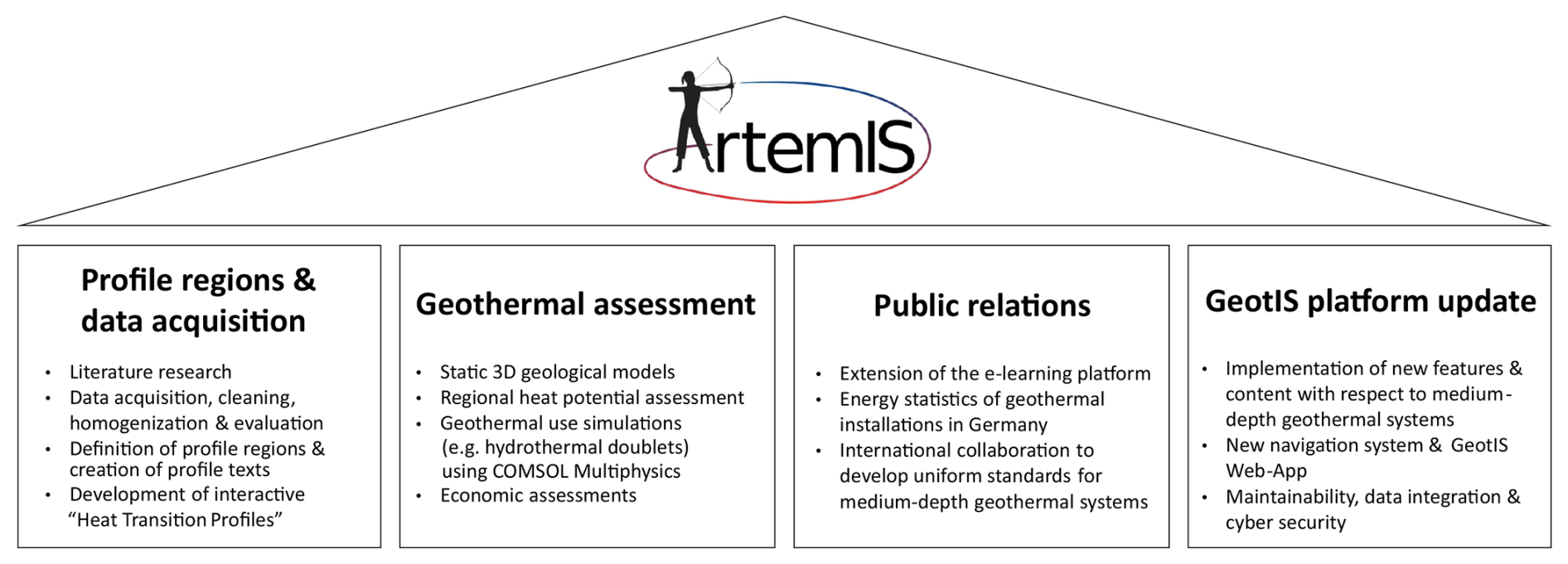
Figure 1The ArtemIS project is structured around four key pillars: developing dynamic heat-transition profiles for the GeotIS platform, conducting geothermal and economic assessments of various geological settings across Germany, public relations, and updating and expanding the GeotIS platform.
In the following sections, each of these tasks is briefly outlined, and the preliminary results are presented in Sect. 3.
2.1 Profile Regions and Data Acquisition
In order to define profile regions, the different geological settings in Germany were first classified regarding their geothermal play type, an approach introduced by Moeck (2014) and Moeck et al. (2019) that groups geothermal resources based on their geological setting and dominant heat transport mechanism (Fig. 2). Four play types are recognized in Germany: (1) CD1-intracratonic basins, (2) CD2 (fold-and-thrust belts) subdivided into CD2a-foreland basins and CD2b-adjacent orogenic fold-and-thrust belt plays, (3) CD3-basement/hard rock plays, and (4) CV3-extensional terrain plays. Thereby, CD refers to conductive heat transport and CV to convective heat transport. The play type concept incorporates different scales of investigation: “geosystem focus,” “play focus,” and “prospect focus”. Exploration begins with the geosystem focus, which describes the large-scale geologic constraints of a geothermal play type and classifies the geosystem into one of the geothermal play type categories (e.g., orogenic belt type, volcanic type, basement type). The next step is to further investigate the identified plays and their regional geologic controls (e.g., porosity and permeability) to identify exploration targets and prospect areas. The final step is a detailed local analysis of these prospect areas. This process requires comprehensive literature reviews and the collection of geophysical, geological, and hydrochemical data to accurately describe and characterize different target reservoirs and their potential geothermal applications. The goal is to allow users to click on any region on the interactive map of Germany on the GeotIS platform (Fig. 3) and display information about potential geothermal reservoirs, including reservoir thickness, lithology, hydraulic and thermal rock properties, hydrochemical fluid properties, and technical specifications. Reservoir data will be categorized based on the geothermal potential, and recommendations for possible geothermal applications will be provided. This information will be complemented with details on existing infrastructure (such as heat networks or power plants) and heat demand across various sectors (e.g., industry, urban areas, agriculture).

Figure 2Classification of play types in Germany (left) after Moeck et al. (2019) and applied workflow within the ArtemIS project (right) to investigate the individual play types after the play type concept (Moeck, 2014) to create interactive heat transition profiles on the GeotIS platform.
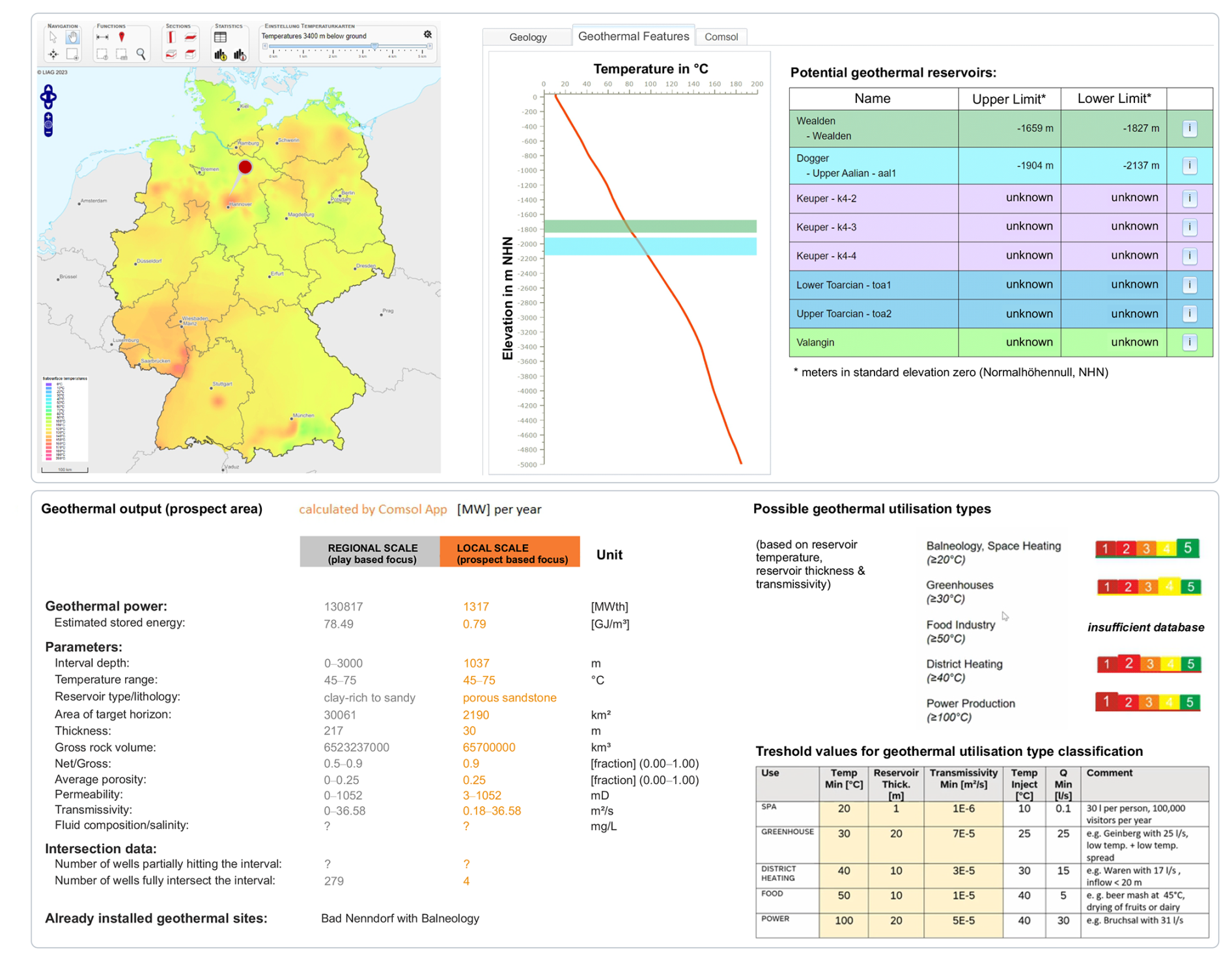
Figure 3Layout for the interactive profile texts on the GeotIS platform with an example for a site north of Hannover in the North German Basin.
2.2 Geothermal Assessment
The information gathered during data acquisition is currently being used to create regional 3D structural models of the different profile regions using Petrel or Gocad SKUA. Well logs and seismic data are being processed and interpreted to improve the geological understanding and define the structural framework and reservoir horizons. Rock properties obtained from laboratory measurements on core and outcrop samples (provided by literature, geological surveys or own measurement campaigns) are used for model parameterization. The regional models are then used for a first regional heat assessment (e.g., heat-in-place method according to Muffler and Cataldi, 1978) and also serve as a basis for 3D reservoir models using the software COMSOL Multiphysics. This software was specifically chosen for the GeotIS platform due to its robust, industry-standard simulation capabilities, complemented by its Application Builder and Server solutions. These features enable seamless application management and maintenance while supporting the creation of intuitive, user-friendly interfaces, ensuring that models and results are both easily accessible and practical for users (on PC, mobile phone or tablet). The reservoir models are used to simulate different geothermal utilization scenarios (e.g., hydrothermal doublets) and the heat extraction potential at a local scale. The goal is to create multiple numerical subsurface models representing a variety of geologic settings and structural conditions to cover all play types. The primary focus of the COMSOL models is on regions that have not yet been extensively studied, enhancing the GeotIS database and providing users with an assessment of the overall geothermal potential in a region (including worst- and best-case scenarios and temporal effects such as the thermal break-through time) to encourage the development of new geothermal projects. Towards the end of the project, the modeling results will be integrated into the GeotIS platform within the Heat Transition Profiles section (under the COMSOL tab, Fig. 3). Additionally, plans are in place to make the models accessible through the COMSOL App. This feature will allow users to modify input parameters, such as hydraulic properties, pumping rates, or well distances, run simulations on the LIAG COMSOL server, and obtain the results along with a detailed report.
2.3 Public Relations
To improve knowledge transfer and the public outreach, production data and energy statistics of the geothermal installations in Germany will be implemented and constantly updated on the GeotIS platform. This will provide users with detailed insights into key parameters such as total installed capacity, annual production, reservoir temperature, and flow rate. Furthermore, e-learning modules using different media (e.g., brochures, interactive web-pages or video clips) are being developed. Detailed explanations of each profile region, the various play types, and the potential applications of geothermal energy will be provided, ensuring the information is accessible to non-experts, policymakers, and municipal utilities. To reach a wider audience, these e-learning modules will be offered in both German and English. Furthermore, collaboration with the international geothermal community, including partnerships with organizations such as IEA Geothermal, EERA-JPGE, and ETIP-DG, will help establish consistent assessment standards for medium-depth geothermal reservoirs.
2.4 Update of the GeotIS Platform
Last but not least, a major task is to update and adapt the IT infrastructure to host the GeotIS platform and introduce new features such as dynamic heat transition profiles and include the results of the COMSOL models. The user interface will be redesigned to be more intuitive and user-friendly with a new navigation system. Emphasis will also be placed on the maintainability of the platform, the integration of new data and cybersecurity. Furthermore, a GeotIS web application will be developed to improve the usability of the platform on mobile devices.
3.1 Interactive Heat Transition Profiles on the GeotIS platform
The extent and outline of the play types and profile regions for the GeotIS platform are displayed in Fig. 2, which classifies the geological regions in Germany into “Extension terrain” (e.g., Upper Rhine Graben), “Foreland basin” (South German Molasse Basin), “Intracratonal basin” (e.g., Paris Basin), “Basement/hard rock” (e.g., Black Forest), and “Adjacent orogenic belt” (e.g., Harz Mountains). The first profile texts and templates for the dynamic heat transition profiles on the GeotIS platform were developed. An example for the North German Basin is presented in Fig. 3. The user clicks on an area on the Germany map and the information for the respective play type is displayed, which includes (1) a summary of the regional geological setting, (2) an overview of potential geothermal reservoirs, and (3) in the future, results of reservoir simulations for different geothermal use scenarios performed with the software COMSOL Multiphysics. Whenever available, associated geological and technical parameters are automatically generated and displayed in the heat-transition profile for the respective area for different investigation scales (e.g., play focus or prospect focus). Simplified geological maps and cross sections complement the brief descriptions of the regional geological setting and potential geothermal reservoirs for better understanding. Based on Agemar et al. (2017) a classification for the different geothermal utilization types was implemented. It contains five levels ranging from class 1 (balneology, space heating, ≥ 20 °C) to class 5 (≥ 100 °C, power production). Besides reservoir temperature, the classification considers reservoir thickness, transmissivity, injection temperature and flow rates (Fig. 3).
3.2 Data evaluation and 3D structural modeling
Different static 3D geological models are currently under construction. Results for the play types “North German Basin (NGB)” and “Upper Rhine Graben (URG)” are presented in Figs. 4 and 5. The NGB is a key region for geothermal energy due to its substantial sediment thickness and favourable geological structures. While successful geothermal projects have been carried out in the eastern part of the NGB, such as in the Müritz region, the western part, especially Lower Saxony, lacks permanent commercial geothermal operations. Although Lower Saxony has a history of intensive hydrocarbon exploration, many potential geothermal reservoirs remain under-investigated. Among the promising medium-depth geothermal reservoirs in the NGB, the Upper Maastrichtian Calcarenite (Reitbrook Formation) is particularly notable. Numerous wells from the hydrocarbon industry have intersected these calcarenites in the past, occasionally serving for wastewater disposal within the oil and gas sector, indicating substantial porosity and permeability. To construct a 3D geological model, the distribution of the calcarenites was mapped and their reservoir properties were characterized using 153 well logs from the hydrocarbon database (FIS-KW) and core data from 7 wells. Porosity and permeability data from the few available core samples range from approximately 8 % to 38 % and less than 1 to 2000 mD (∼ 10−16 to 10−12 m2), respectively, with the majority of the data falling within the high porosity (∼ 20 %–32 %) and moderate to high permeability range (10−15 to 10−13 m2). The investigation of the borehole data reveal that the “Flinte Marly Limestone” layer, identified in numerous logs, serves as a reliable marker beneath the potentially suitable calcarenites, which can be subdivided into an upper and lower section separated by a marlier horizon (Fig. 4d). Furthermore, a lateral facies change is observed, transitioning from pure arenites in the north to glauconitic sands in the south, creating a mixed facies reservoir. This sand facies may be coarser-grained, enhancing porosity and permeability. Vertically, grain size and glauconite content increase with stratigraphic height, making the Upper Arenite/Sandstone the primary exploration target. Thickness varies significantly, up to 275 m in some areas, yet the arenites could also be eroded and no longer present beneath the Paleogene transgression. Top depths range from 434 to 1647 m, with thickness influenced by halokinetics, especially near salt diapirs. Therefore, the greatest thicknesses of the reservoir can be expected in the margins of the salt diapirs. Overall, tectonic activity during the Upper Cretaceous caused higher subsidence in the north, leading to predominant arenite deposition, while glauconitic sandstone likely originated from the south/southeast, reworked from uplifted basin parts. To better map the thickness and depth variations of the potential reservoirs 3D seismic is currently being processed and interpreted as shown in Fig. 4e.
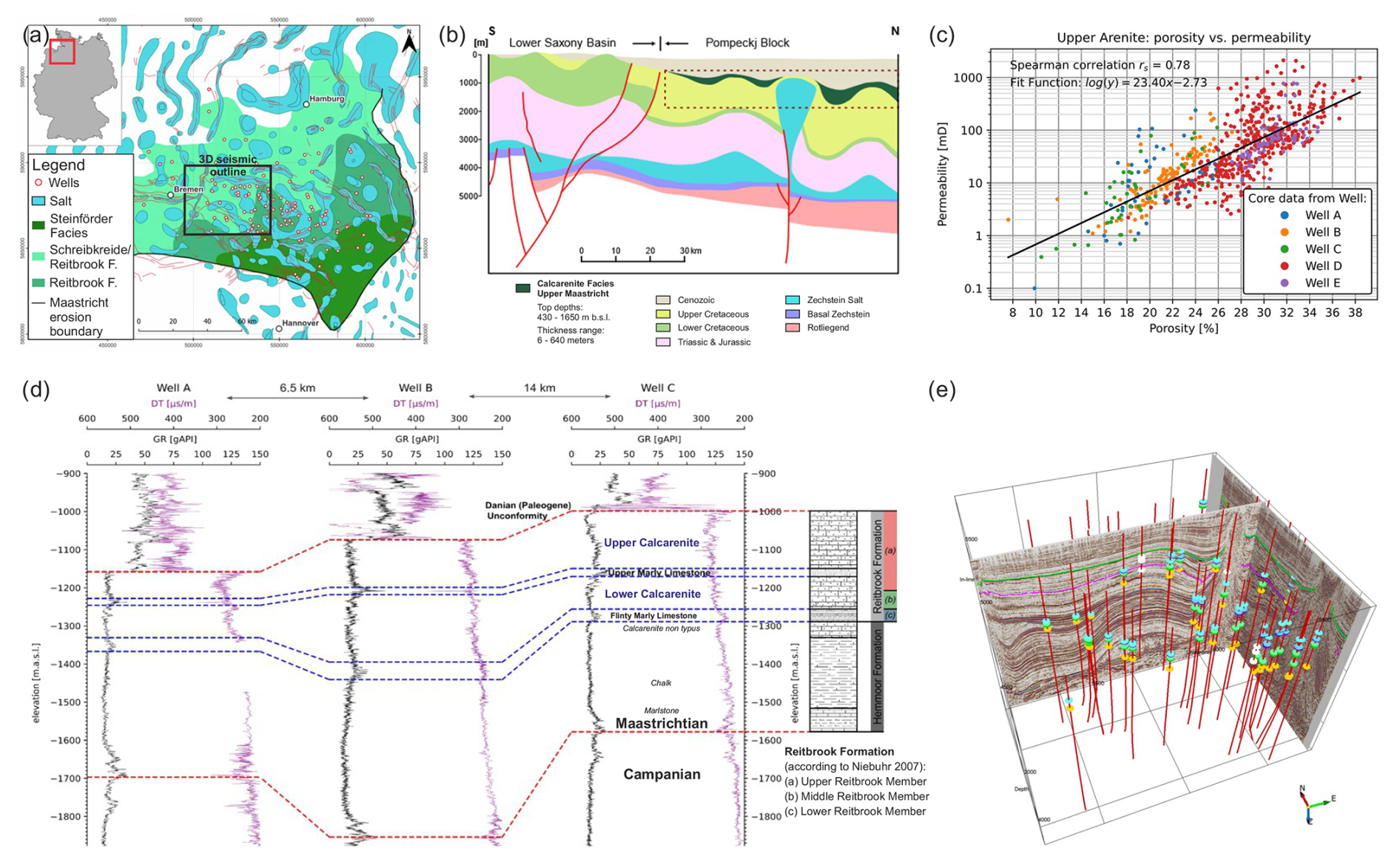
Figure 4Overview map of the study area in the North German Basin (NGB) displaying the outline of the salt diapirs and arenite/sandstone facies (a). Schematic cross-section of the southern part of the study area (b), where the inversion of the Lower Saxony Basin led to the absence of the Maastrichtian deposits. (c) Cross-plot of permeability and porosity retrieved from wellbore core samples of the Upper Arenite/Sandstone. (d) Lithostratigraphic correlation of three wells in the central part of the study area in comparison with the stratigraphy of the Reitbrook Formation presented in Niebuhr et al. (2007). (e) Current work on 3D seismic interpretation including 53 boreholes in order to map the thickness and depth variation of the reservoir.
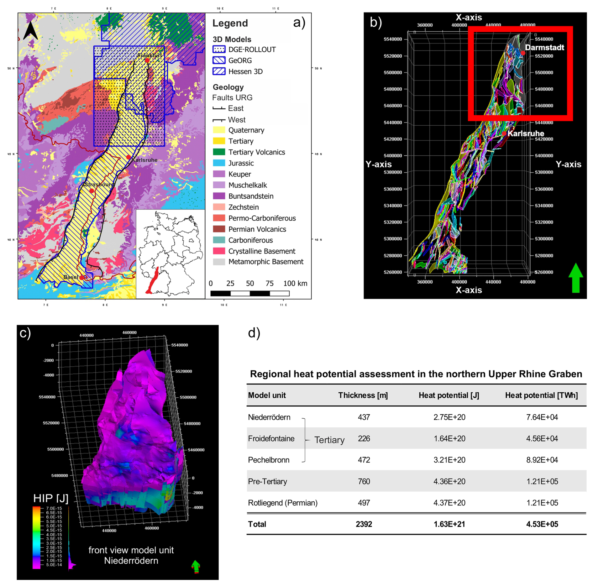
Figure 5Geological map of the Upper Rhine Graben area in southern Germany (a) modified from Frey et al. (2022) showing the extent of previous studies in blue. (b) Preliminary structural model of the Upper Rhine Graben based on available data from previous projects. 3D model of the northern Upper Rhine Graben (c) illustrating the heat potential (d) using the Heat-in-Place method after Muffler and Cataldi (1978).
Several successful geothermal projects have been carried out in the Upper Rhine Graben (Frey et al., 2022). The URG is classified as a convection-dominated, and fault-controlled geothermal system in an extensional domain (Moeck, 2014). Since fluid flow and effective heat transport mainly occur along permeable fault zones, depicting the complex fault system within the URG in a 3D model is crucial. For the URG fault model, data and 3D models from previous research projects such as DGE Rollout (van der Vaart et al., 2021), Hessen 3D (Bär et al., 2021), and GeORG (http://www.geopotenziale.org, last access: 20 November 2024) were combined and merged using the Petrel software (Fig. 5a). Overlap errors, such as variations in horizon thickness, fault length, and orientation across different models – resulting from varying subsurface interpretations or differences in data density for specific areas – were resolved and homogenized using seismic and well log data (van der Vaart et al., 2021). New 3D seismic datasets are currently processed to update and validate the preliminary fault model (Fig. 5b). Lithological and geophysical well logs provided by geological surveys are being digitized and utilized to establish or update the model horizons. Rock property data, measured in laboratories from core and outcrop samples (summarized in Frey et al., 2022) were collected from existing literature and provided by the Geological Survey of Hesse (Hessian Agency for Nature Conservation, Environment, and Geology, HLNUG) to ensure comprehensive model parameterization. To address existing data gaps, this dataset will be augmented by ongoing outcrop analogue studies in the Upper Rhine Graben area. For the area of the northern Upper Rhine Graben, a first 3D structural model was created and used for a regional heat-in-place assessment (Fig. 5c) after Muffler and Cataldi (1978). At the moment, the model distinguishes between five model units representing the Tertiary, Pre-Tertiary and Permo-Carboniferous indicating a good potential for heat production (Fig. 5d).
The results of the 3D structural modeling will be integrated into the GeotIS platform at the end of the project as described by Agemar et al. (2018), with all model outputs converted to TS-files (GeotIS source model overview: https://www.geotis.de/homepage/references?ref=mo, last access: 20 November 2024).
3.3 Reservoir Simulations
For the NGB the first COMSOL models with a size of 8 × 8 km were set up (Fig. 6a) to systematically analyze the impact of reservoir quality and operational controlling factors on the performance of typical Mesozoic sandstone reservoirs targeted by smart multi-well arrangements (Mantei et al., 2024; please refer to the Supplement for more information). Simple layer cake models (sandstone aquifer confined by impermeable shales, marls, and siltstones) with varying reservoir thickness (20–35 m), porosity (15 %–30 %) and permeability (1–800 mD) were constructed to simulate hydrothermal doublets. For the geothermal doublet array, a set of eight injection wells and eight production wells were positioned in a chessboard pattern (Fig. 6b) with varying inter-well spacing (500–1200 m) and a geothermal gradient of 30 °C km−1, injection temperatures ranging from 17 to 26 °C, and a pumping rate of 30 to 60 L s−1 were applied. Previous analytical results provided in Jobmann and Schulz (1989) were then compared with the new numerical simulations to quantify the influence of different controlling factors on the thermal breakthrough occurrence time, the maximum cooling rate after the occurrence of the thermal breakthrough and the final production temperature (Fig. S5). A ranking scheme was set up showing the influence of varying input parameters on the considered performance parameters (Fig. 6c). For the thermal breakthrough occurrence time, the inter-well distance has the highest influence followed by the pumping rate, thickness, permeability/porosity, number of neighboring wells, and injection temperature. The results also showed a much higher delay in thermal breakthrough occurrence time in a hydrothermal doublet array pattern compared to a single doublet layout (Fig. S6). With respect to the maximum cooling rate, again the inter-well distance possessed the highest influence, followed by the pumping rate, number of neighboring wells, injection temperature, thickness, and lastly permeability/porosity.
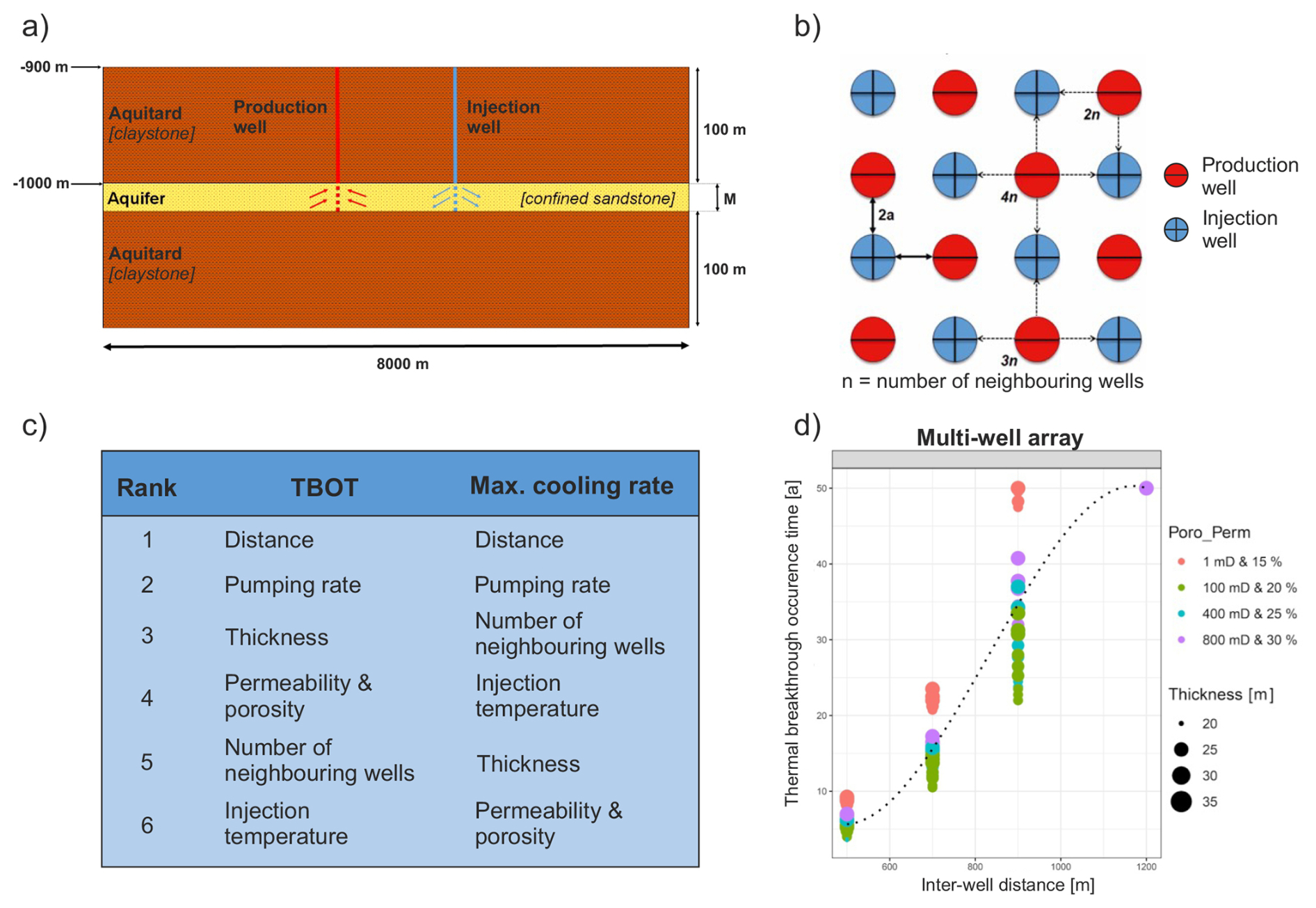
Figure 6Schematic sketch of the layer-cake COMSOL models (a) and the multi doublet array in a chessboard pattern (b). The results of the numeric simulations were implemented in a ranking scheme for operational parameters (c). Panel (d) represents the simulation of the thermal breakthrough occurrence time (TBOT) in dependence of inter-well distance, reservoir thickness, porosity and permeability (modified from Mantei et al., 2024).
3.4 Energy Statistics
In addition to a new layout, color scheme and navigation system to make the GeotIS platform more user-friendly (Fig. S2), new “Energy Statistics” data have been implemented. The data is collected annually directly from the energy companies or operators of the various geothermal installations in accordance with IEA Geothermal. The platform now offers annual data on geothermal electricity and heat production in Germany, along with the installed capacities starting from 1999. Figure 7 illustrates a consistent rise in geothermal electricity and heat output in recent years. In 2023, annual heat production reached approximately 2010 GWh (∼ 454 MW installed capacity), while electricity production, though considerably lower, accounted for 198 GWh with an installed capacity of 47.3 MW, supported by ten operational geothermal power plants. District heating represents almost three-quarters of the annual heat production, followed by thermal spas (∼ 26 %) and space heating (∼ 0.5 % or ∼ 10 GWh). While geothermal heat production in Germany continues to grow steadily, the expansion of geothermal electricity generation appears to have stagnated. Variations in electricity and heat production rates (Fig. 7) over time are partly influenced by maintenance activities at power plants, the expansion of heating networks and an increased emphasis on heat production over electricity generation. On GeotIS, users can select various data display options (e.g., choosing specific datasets) and download the corresponding tables. Beyond national annual production data, users can access information by individual power plants or federal states. The data can also be viewed as a 2D map showcasing geothermal installations.
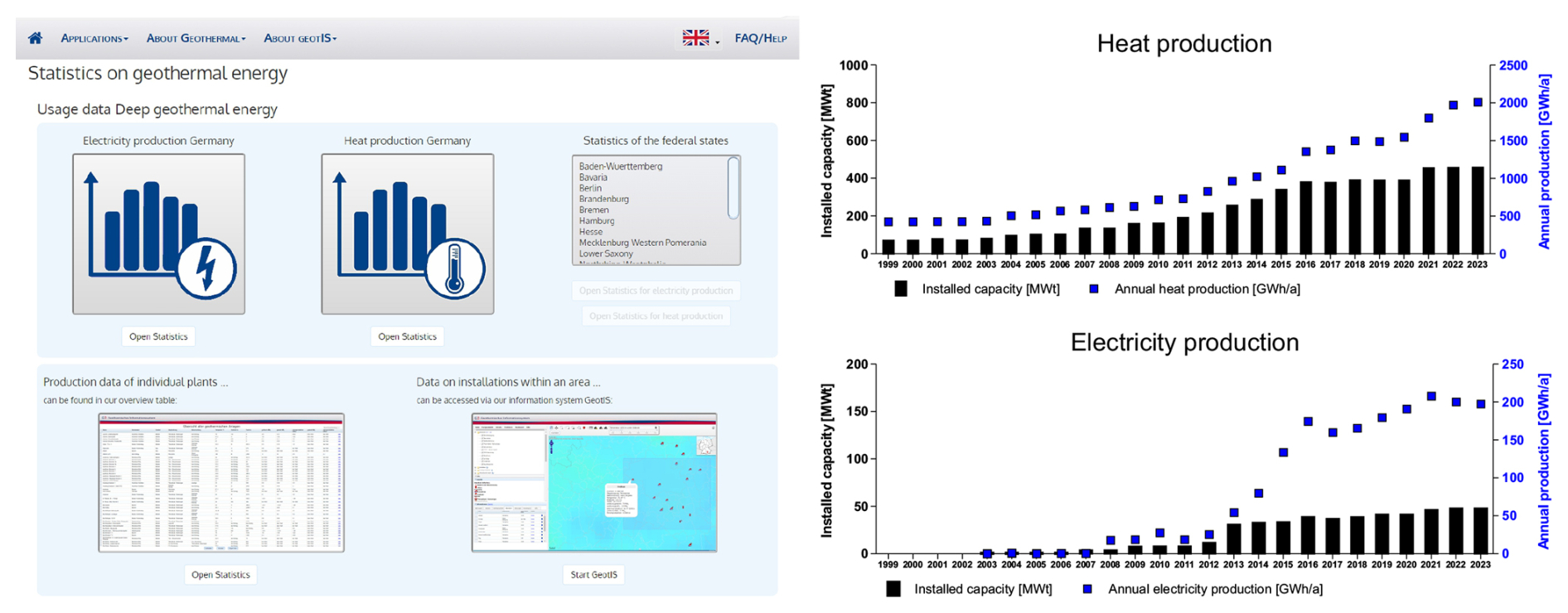
Figure 7Overview and new design of the “Energy Statistics” category on the GeotIS platform (left) and the production of geothermal heat and electricity in Germany over the years (right).
The Artemis project aims to advance Germany's energy transition by promoting public awareness and systematically assessing the medium-depth geothermal potential in different geological settings across the country, categorized into so-called play types. The project enhances the German Geothermal Information System GeotIS by providing regionalized information through interactive, user-friendly heat-transition profiles, energy statistics, e-learning modules and new modeling results (regional 3D structural models using Petrel or Gocad SKUA and geothermal use simulations in COMSOL on a local scale).
In this article the first results for the play types North German Basin and Upper Rhine Graben are presented. As a first step, geological, geophysical, hydrochemical and well data were collected, preprocessed and analyzed to create preliminary 3D models and geological descriptions for the interactive heat transition profiles on the GeotIS platform. Based on the evaluation of borehole and core data in the North German Basin, the Upper Maastrichtian Calcarenites showed promising reservoir properties with porosities and permeabilities of up to 38 % and 2000 mD, respectively. The arenites/sandstones formed synsedimentarily from the interplay between an overarching tectonic inversion, halokinesis, and regression, which led to notable lateral and vertical heterogeneities regarding e.g., reservoir thickness, grain size or glauconite content throughout the study area. Similar efforts were conducted for the Upper Rhine Graben play type, where data from multiple sources were integrated to develop a preliminary fault model. A regional heat-in-place assessment of the Northern Upper Rhine Graben revealed promising potential for geothermal heat production. Current efforts are focused on processing and interpreting well logs and 2D and 3D seismic data to refine the structural models, accurately delineate reservoir horizons and estimate reservoir thickness. In the North German Basin, this work is expected to improve the understanding of halokinesis processes and the spatial distribution of salt structures. Meanwhile, in the Upper Rhine Graben, these efforts aim to better understand the complex fault systems and provide more precise definitions of Tertiary model units, contributing to more reliable geothermal resource assessments.
For the North German Basin 3D numerical simulations were carried out to investigate the impact of reservoir quality and operational controlling factors on the performance of typical Mesozoic sandstone reservoirs targeted by an array of hydrothermal doublets. A ranking scheme for influential parameters has been established, showing that the distance between wells and reservoir thickness have the highest impact on the occurrence time of thermal breakthrough and the cooling rate in these reservoirs. The delay of thermal breakthrough in doublet arrays is greater than in single doublets, indicating that smart multi-well systems are a promising tool to meet the urban heat demand in Germany. Since the current simulations consider only simple layer-cake models of the Mesozoic sandstones, this method will be applied to a high-resolution facies-based model supported by well data in Mecklenburg-Western Pomerania to account for complex sedimentary architectures. Likewise, similar generic, play-type specific reservoir models will be created for representative geological settings in the Upper Rhine Graben to simulate the regional heat-extraction potential and different geothermal use scenarios.
The layout of the interactive heat transition profile has been developed, and the GeotIS platform is being gradually updated to incorporate new features and design elements. New data on geothermal heat and electricity production in Germany has been integrated, showing a consistent annual increase in heat production, while the expansion of electricity production remains stagnant. Most technical information and features are now available in English and will be supplemented with e-learning modules, brochures, and videos on medium-depth geothermal reservoirs, the various play types in Germany, and their potential uses. These new resources and features on the GeotIS platform will help municipal utilities and stakeholders to better understand and evaluate regional medium-depth geothermal potential, thereby accelerating the heat transition in Germany. The ArtemIS project will improve the understanding of medium-depth geothermal reservoirs and contribute to the establishment of international standards for their characterization and assessment.
All data used are displayed in this paper and in the Supplement. Further information is available under http://www.geotis.de.
The supplement related to this article is available online at https://doi.org/10.5194/adgeo-65-199-2025-supplement.
All authors read, revised and contributed to this article.
The contact author has declared that none of the authors has any competing interests.
Publisher's note: Copernicus Publications remains neutral with regard to jurisdictional claims made in the text, published maps, institutional affiliations, or any other geographical representation in this paper. While Copernicus Publications makes every effort to include appropriate place names, the final responsibility lies with the authors.
This article is part of the special issue “European Geosciences Union General Assembly 2024, EGU Division Energy, Resources & Environment (ERE)”. It is a result of the EGU General Assembly 2024, Vienna, Austria, 14–19 April 2024.
The authors would like to thank three anonymous referees for their valuable comments which helped to improve the quality of this article.
This research has been supported by the Bundesministerium für Wirtschaft und Klimaschutz (grant no. 03EE4024).
This paper was edited by Giorgia Stasi and reviewed by three anonymous referees.
Agemar, T., Alten, J.-A., Ganz, B., Kuder, J., Kühne, K., Schumacher, S., and Schulz, R.: The Geothermal Information System for Germany – GeotIS, Z. Dt. Ges. Geowiss., 165, 129–144, https://doi.org/10.1127/1860-1804/2014/0060, 2014.
Agemar, T., Hese, F., Moeck, I., and Stober, I.: Kriterienkatalog für die Erfassung tiefreichender Störungen und ihrer geothermischen Nutzbarkeit in Deutschland [List of criteria for the geothermal survey of deep-reaching faults in Germany.], Z. Dt. Ges. Geowiss., 168, 285–300, https://doi.org/10.1127/zdgg/2017/0084, 2017.
Agemar, T., Tribbensee, K., Görne, S., and Obst, K.: 3D-Modell geothermischer Nutzhorizonte Nordostdeutschlands in GeotIS [3D model of geothermal horizons located in northeastern Germany in GeotIS.], Z. Dt. Ges. Geowiss., 169, 343–351, https://doi.org/10.1127/zdgg/2018/0127, 2018.
Bär, K., Schäfer, R., Weinert, S., and Sass, I.: Verbundprojekt “Hessen 3D 2.0”: 3D-Modell der geothermischen Tiefenpotenziale von Hessen – Petrothermale Potenziale und Mitteltiefe Potenziale zur Wärmenutzung und Wärmespeicherung (Teilvorhaben A), Schlussbericht zum BMWi-geförderten Verbundprojekt “Hessen 3D 2.0” (FKZ 0325944A), 194 pp., Technical University of Darmstadt, 2021.
Bossennec, C., Seib, L., Krusemark, M., Weydt, L., Meinaß, H. P., Frey, M., Scheuvens, D., Hesse, K., Wonik, T., Buness, H., and Sass, I.: Characterisation of a complex faulted crystalline environment targeted for medium deep thermal energy storage, SKEWS MD-BTES demonstration site, Geothermal Energy, in press, 2025.
BGR: Warm-Up – Geothermie für die Wärmewende: Flankierung des Rollouts der mitteltiefen Geothermie in Deutschland, Bundesanstalt für Geologie und Rohstoffe, https://www.bgr.bund.de/DE/Themen/Nutzung_tieferer_Untergrund_CO2Speicherung/Projekte/Geothermie/Laufend/Warm-Up.html (last access: 28 June 2024), 2024.
DGMK: Projektstart: Geschlossene mitteltiefe Geothermiesysteme für die dezentrale Wärmeversorgung, Deutsche Wissenschaftliche Gesellschaft für nachhaltige Energieträger, Mobilität und Kohlenstoffkreisläufe e. V., https://dgmk.de/news/projektstart-geschlossene-mitteltiefe-geothermiesysteme-fuer-die-dezentrale-waermeversorgung/ (last access: 24 June 2024), 2023.
European Union: Luxembourg's integrated national energy and climate plan for 2021–2030, Report, Le Gouverment Du Grand-Duché De Luxembourg, 190 pp., https://energy.ec.europa.eu/system/files/2020-07/lu_final_necp_main_en_0.pdf (last access 24 June 2024), 2020.
Frey, M., Bär, K., Stober, I., Reinecker, J., van der Vaart, J., and Sass, I.: Assessment of Deep Geothermal Research and Development in the Upper Rhine Graben, Geothermal Energy, 10, 18, https://doi.org/10.1186/s40517-022-00226-2, 2022.
HLNUG: Mitteltiefe Geothermie, Hessisches Landesamt für Naturschutz, Umwelt und Geologie (HLNUG), https://www.hlnug.de/themen/geologie/erdwaerme-geothermie/mitteltiefe-geothermie (last access: 30 June 2024), 2023.
Jobmann, M. and Schulz, R.: Hydrogeothermische Energiebilanz und Grundwasserhaushalt des Malmkarstes im süddeutschen Molassebecken, Abschlussbericht, Band I, Archiv Nr. 105040, Niedersächsisches Landesamt für Bodenforschung, 1989.
LIAG: mesoTherm – Erkundung und Erschließung hydrothermaler Reservoire der mitteltiefen Geothermie – ein Beitrag zur Wärmewende in Norddeutschland, LIAG Institut für Angewandte Geophysik, https://www.leibniz-liag.de/forschung/projekte/drittmittelprojekte/mesotherm.html (last access: 24 June 2024), 2024.
Mantei, N., Rioseco, E. M., and Moeck, I. S.: 3D numerical study of geothermal reservoir performance of homogeneous sectors of Mesozoic sandstone formations in the North German Basin developed by smart multi-well systems, Geothermal Energy, 81 pp. [preprint], https://doi.org/10.21203/rs.3.rs-4808466/v1, 2024.
Moeck, I.: Catalog of geothermal play types based on geologic controls, Renew. Sust. Energ. Rev., 37, 867–882, https://doi.org/10.1016/j.rser.2014.05.032, 2014.
Moeck, I., Dussel, M., Weber, J., Schintgen, T., and Wolfgramm, M.: Geothermal play typing in Germany, case study Molasse Basin: A modern concept to categorise geothermal resources related to crustal permeability, Neth. J. Geosci., 98, E14, https://doi.org/10.1017/njg.2019.12, 2019.
Muffler, P. and Cataldi, R.: Methods for regional assessment of geothermal resources, Geothermics, 7, 53–89, 1978.
Niebuhr, B., Hiss, M., Kaplan, U., Tröger, K.-A., Voigt, S., Voigt, T., Wiese, F., and Wilmsen, M.: Lithostratigraphie der norddeutschen Oberkreide, Schriftenreihe der Deutschen Gesellschaft für Geowissenschaften, 55, 136 pp., ISBN 978-3-510-49202-2, https://www.schweizerbart.de/publications/detail/artno/171905500 (last access: 20 March 2025), 2007.
Sass, I.: Mitteltiefe Geothermie – Standortanforderungen, Technik und Praxisbeispiele, Fachgespräch Erdwärmenutzung in Hessen, 17.09.2013, Idstein, Germany, https://www.google.com/url?sa=t&source=web&rct=j&opi= 89978449&url=https://www.hlnug.de/fileadmin/dokumente/ geologie/erdwaerme/fachgespraech/2013/Fachgespraech_Erd waerme_2013_Sass.pdf&ved=2ahUKEwil3dGy1Z2MAxURA IHHQ5nFUYQFnoECA8QAQ&usg=AOvVaw0ou-y4N85PrK_pNNX0WNP9 (last access: 20 March 2025), 2013.
Sass, I., Krusemark, M., Seib, L., Bossennec, C., Pham, T. H., Schedel, M., Weydt, L., Buness, H., and Homuth, B.: Medium-Deep Borehole Thermal Energy Storage (MD-BTES): from Exploration to District-Heating Grid Connection, Insights from SKEWS and PUSH-IT Projects, Proceedings 49th Workshop on Geothermal Reservoir Engineering, Stanford University, Stanford, California, USA, 12–14 February 2024, SGP-TR-227, 12 pp., https://www.google.com/url?sa=t&source=web&rct=j&opi= 89978449&url=https://pangea.stanford.edu/ERE/db/GeoConf/ papers/SGW/2024/Sass.pdf&ved=2ahUKEwiUwOH01Z2MAx W4ygIHHZUKKUUQFnoECA8QAQ&usg=AOvVaw2XUgOm S5ZjEdtqQMnOhz-u (last access: 20 March 2025), 2024.
Seib, L., Frey, M., Bossennec, C., Krusemark, M., Burschill, T., Buness, H., Weydt, L., and Sass, I.: Assessment of a medium-deep borehole thermal energy storage site in the crystalline basement: A case study of the demo site Lichtwiese Campus, Darmstadt, Geothermics, 119, 102933, https://doi.org/10.1016/j.geothermics.2024.102933, 2024.
Stadt Schwerin: Geothermie in Schwerin – ein Meilenstein in der Wärmewende: Deutschlandweit erste mitteltiefe Geothermie-Anlage mit Wärmepumpen geht in Betrieb, https://www.schwerin.de/news/geothermie-geht-in-betrieb/ (last access: 24 June 2024), 2023.
Stober, I. and Bucher, K.: Geothermal Energy – From Theoretical Models to Exploration and Development, 2nd edn., Springer, Cham, Switzerland, 390 pp., https://doi.org/10.1007/978-3-030-71685-1, 2021.
Umweltbundesamt: Energieverbrauch für fossile und erneuerbare Wärme, Umweltbundesamt, https://www.umweltbundesamt.de/daten/energie/energieverbrauch-fuer-fossile-erneuerbare-waerme (last access: 29 June 2024), 2024.
van der Vaart, J., Bär, K., Frey, M., Reinecker, J., and Sass, I.: Quantifying model uncertainty of a geothermal 3D model of the Cenozoic deposits in the northern Upper Rhine Graben, Germany, Z. Dt. Ges. Geowiss., 172, 365–379, https://doi.org/10.1127/zdgg/2021/0286, 2021.
Weber, J. and Moeck, I.: Heat transition with geothermal energy – chances and opportunities in Germany, brochure, Leibniz Institute for Applied Geophysics, Hannover, 12 pp., https://www.geotis.de/homepage/sitecontent/info/publication_data/public_relations/public_relations_data/Liag-Brosch-waermewende-eng.pdf (last access: 24 June 2024), 2019.
Weydt, L., Agemar, T., Bär, K., Erb, M., Dobrzinski, N., Mantei, N., Moeck, I., Singh, M., Sperlich, S., van der Vaart, J., Weber, J., and Sass, I.: Assessment for medium-depth geothermal energy utilization in Germany – first results from the ArtemIS project, Proceedings Geothermal Rising, 1–4 October 2023, Reno, Nevada, USA, GRC Transactions, Vol. 47, 11 pp., ISBN 9781713884002, https://www.proceedings.com/71719.html (last access: 20 March 2025), 2023.