Articles | Volume 64
https://doi.org/10.5194/adgeo-64-33-2024
28 Oct 2024
 | 28 Oct 2024

Generation of spatial grids for hydrometeorological data in hydrogeological investigations for Colombia

Leonardo David Donado and Omar Alfredo Mercado
Abstract

In Colombia, water resources management is carried out with insufficient hydrometeorological information in most of the territory. Natural and social conditions make it complex and difficult to densify the monitoring of primary variables for analysis. As a result, decisions often have to be made based on national scale studies, extrapolating information from areas with somewhat better monitoring coverage. The objective of this study is to estimate hydrometeorological data with a spatial resolution that allows decision making on water resources management from the national government level to the local level. For this purpose, multivariate regression models are used where data are fitted from meteorological station measurements taken for the time period 1981–2016.

1 Watersheds subject to strategic planning (Hydrographic Areas)

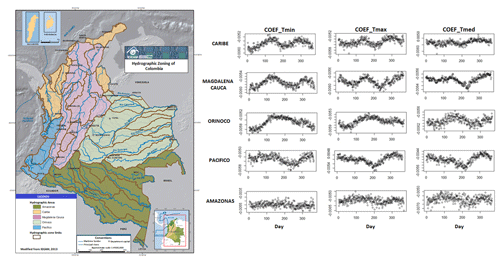
Large regions that group basins and rivers that flow into the same sea are known as hydrographic areas (IDEAM, 2013) (Fig. 1). Normally, strategic plans for hydrographic areas or macro-basins are formulated at a scale of 1:500 000 or at a more detailed level only when the available information allows it. In Colombia there are five hydrographic areas, four of which strictly comply with the definition of hydrographic macro-basins: Orinoquia, Amazonia, Caribbean and Pacific. The fifth hydrographic area was defined according to its importance in the socioeconomic context of the country and was called the Magdalena-Cauca hydrographic zone. In addition, the country has divided these areas into subgroups such as zones, subzones and hydrographic units. Despite these subdivisions, management in most of these subgroups is carried out with insufficient information from regional-scale monitoring.

2 Multivariate regression models

For the methodological development and estimation of the data of different meteorological variables in this work, multivariate regression models that related both variables and meteorological parameters were used (Risco and Lavado, 2015). The specific objective of the study is to generate data grids of the variables temperature (T), precipitation (P), soil moisture (SM), runoff (Ro), and solar radiation (SR), in order to calculate the potential recharge of the aquifers. The meteorological variables were related to the following parameters: longitude (Lon), latitude (Lat), elevation (E), terrain aspect (TA), soil type (ST) and vegetation cover (VC), which were calculated (Eq. 1):

(1) Υ i = β 0 + β 1 X i 1 + + β p X i p + μ i ,

where Υi is T, P, Ro, SM and SR, βi is model coefficients, Xi is Lon, Lat, E, TA, ST and VC, μi is estimation error.

2.1 Characterization of vertical temperature gradients by hydrographic area

Temperature was the main adjustment variable, given its high correlation with the elevation of the terrain and its changes in distribution marked by changes in precipitation and vegetation cover. In this work, calculations were made for different DEMs, with the 90 m DEM being the most optimal over the highest resolution ones, taking into account factors such as the uncertainties and computational capacity. The expected seasonal behavior of the temperature gradient is confirmed by determining the vertical gradients for each of the five hydrographic areas (Fig. 1).

https://adgeo.copernicus.org/articles/64/33/2024/adgeo-64-33-2024-f01

Figure 1Left: Study area (Hydrographic Areas) (IDEAM, 2013). Right: coefficients of vertical temperature gradients.

2.2 Evaluation of potential evapotranspiration and potential recharge

From the temperature and solar radiation data (Samani, 2000), evapotranspiration (ET) was calculated using the Hargreaves formula (Hargreaves and Samani, 1985) (Eq. 2):

(2) ET = 0.0023 T med + 17 , 78 Ro ( T max - T min ) 0 , 5 ,

Where Tmed, Tmax and Tmin are the mean, maximum and minimum temperatures respectively.

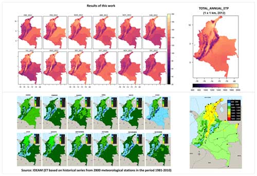
The ET values calculated with the Hargreaves formula for a grid spacing of 1 km2 are similar to those obtained with the Penman-Monteith formula (Allen et al., 1998) at the locations where there are stations (Fig. 2).

After estimating the values of the meteorological variables from the multivariate regression models and performing a cross-validation process against the data measured at the hydrometeorological stations, different methods were tested to calculate the potential recharge (Islam et al., 2016), choosing a water balance method based on surface water and meteorological variables (Bradbury et al., 2000) and calculating the recharge as follows (Eq. 3):

(3) R = P - Ro - ET - Δ SM ,

Where R is potential recharge, P is precipitation, Ro is runoff, ET is evapotranspiration and ΔSM is change in soil moisture.

https://adgeo.copernicus.org/articles/64/33/2024/adgeo-64-33-2024-f02

Figure 2Comparison between ET calculated. Up: Hargreaves formula. Down: Penman-Monteith method (IDEAM, 2013).

2.3 Applicability in a Colombian watershed

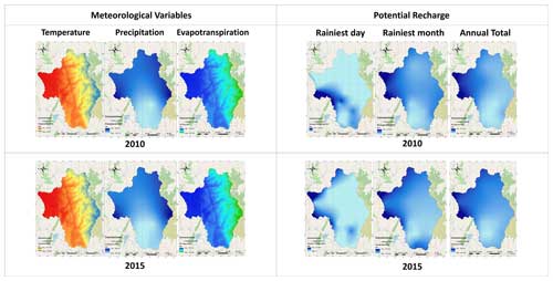
The values for the different meteorological variables were estimated for a spatial resolution of 1 km2 to be later used in the calculation of the potential recharge in the hydrographic sub-zone of the Lebrija River within the Magdalena-Cauca hydrographic area (Fig. 3).

https://adgeo.copernicus.org/articles/64/33/2024/adgeo-64-33-2024-f03

Figure 3Results of data generated from meteorological variables and potential recharge.

The choice of this grid spacing is a result of the sensitivity analyses performed, where varying the grid spacing in the calculation of the potential recharge showed an overestimation of the recharge as the spacing decreased (Stoertz and Bradbury, 1989). When comparing the results using a single-station closure balance method, the calculated values for the potential recharge appear to be overestimated when considering the availability of water from precipitation. This behaviour is mainly due to changes in vegetation cover and land use.

3 Discussion and main conclusions

Data analysis and quality problems. Many of the data measured at the hydrometeorological stations presented problems, particularly in the years 2000, 2001 and 2012, due to the lack of consistency and data gaps that covered up to months. This complicated the analyses at daily and monthly levels, and the data cleaning and completion techniques were not feasible due to the high associated errors. This is where the importance of implementing methodologies for data generation that allow for more accurate estimates of recharge conditions, such as those proposed in this work lies.

Spatial and temporal patterns of recharge. In the example basin, spatial patterns of recharge were identified, mainly influenced by precipitation, soil type, evapotranspiration and soil cover. Areas with predominantly sandy soils showed greater recharge compared to clayey soils, despite having similar precipitation regimes and values.

Impact of the El Niño phenomenon. During the years in which the El Niño phase was present, a pronounced deficit in recharge was observed, with variations in the distribution of precipitation compared to the years in which this phenomenon was not present, modifying in turn the usual patterns of surface temperature. This suggests the need to reevaluate the recharge values used for the management of water resources, especially during these climatic phenomena, to avoid possible overestimations in supply.

Code availability

The different multivariate regressions, data aggregation, validation, sensitivity analyses, as well as graphical representations of the results in this paper were performed using several R packages, such as dplyr, lmtest, spatial, sensemakr and multisensi, all of which are freely available and accessible through the official R websites: https://www.r-project.org/ (R Core Team, 2024).

Data availability

Colombia's meteorological and hydrological data are publicly available on the website of the Institute of Hydrology, Meteorology and Environmental Studies (http://dhime.ideam.gov.co/atencionciudadano/, IDEAM, 2024). The data raw used for the development of this article is available at Zenodo (https://doi.org/10.5281/zenodo.13968447, Mercado, 2024).

Author contributions

LDD: conceptualization, methodology, project administration, supervision, writing – review and editing, formal analysis, visualization; OAM: conceptualization, methodology, investigation, data curation, formal analysis, writing – original draft, writing – review and editing.

Competing interests

The contact author has declared that neither of the authors has any competing interests.

Disclaimer

Publisher's note: Copernicus Publications remains neutral with regard to jurisdictional claims made in the text, published maps, institutional affiliations, or any other geographical representation in this paper. While Copernicus Publications makes every effort to include appropriate place names, the final responsibility lies with the authors.

Special issue statement

This article is part of the special issue “Groundwater management in the context of global change: integrating innovative approaches (EGU2024 HS8.2.1 session)”. It is a result of the EGU General Assembly 2024, Vienna, Austria, 14–19 April 2024.

Acknowledgements

The authors would like to thank Minciencias (Colombia) for its support through the 15th call for proposals of the general royalty system for the department of Casanare. The authors would also like to thank and highlight the work of IDEAM for the provision of the data and that of the anonymous reviewers for their kind comments and suggestions, which contributed to improving this document.

Review statement

This paper was edited by Estanislao Pujades and reviewed by two anonymous referees.

References

Allen, R. G., Pereira, L. S., Raes, D., and Smith, M.: Crop evapotranspiration - Guidelines for computing crop water requirements – FAO Irrigation and drainage paper 56, ISBN 92-5-104219-5, 1998. 

Bradbury, K., Dripps, W., Hankley, C., Anderson, M., and Potter, K.: Refinement of two methods for estimation of ground water recharge rates, University of Wisconsin, https://digital.library.wisc.edu/1711.dl/KFEMSXNDWNLS78L (last access: 27 June 2024), 2000. 

Hargreaves, G. H. and Samani, Z. A.: Reference crop evapotranspiration from temperature, Appl. Eng. Agr., 1, 96–99, https://doi.org/10.13031/2013.26773, 1985. 

Instituto de Hidrología, Meteorología y Estudios Ambientales (IDEAM): Consulta y descarga de datos hidrometeorológicos, http://dhime.ideam.gov.co/atencionciudadano/ (last access: 27 June 2024), 2024. 

Instituto de Hidrología, Meteorología y Estudios Ambientales (IDEAM).: Zonificación y codificación de unidades hidrográficas e hidrogeológicas de Colombia, ISSN: 2346-4720, 2013. 

Islam, S., Singh, R., and Khan, R. A.: Methods of estimating groundwater Recharge, IJEA., 5, 6–9, ISSN 2320-0804, 2016. 

Mercado, O. A.: oamercadod/Data_grid_Hydrometeorology_Lebrija, Zenodo [data set], https://doi.org/10.5281/zenodo.13968447, 2024. 

R Core Team: A language and environment for statistical computing, R Foundation for Statistical Computing, Vienna, Austria, https://www.R-project.org/ (last access: 27 June 2024), 2024. 

Risco, E. and Lavado, W.: Generación de una base de datos de evapotranspiración grillada y de alta resolución a nivel nacional (1981–2014), https://hdl.handle.net/20.500.12542/954 (last access: 27 June 2024), 2015. 

Samani, Z.: Estimating Solar Radiation and Evapotranspiration Using Minimum Climatological data, J. Irrig. Drain. Engrg., 126, 265–267, https://doi.org/10.1061/(ASCE)0733-9437(2000)126:4(265), 2000. 

Stoertz, M. W. and Bradbury, K. R.: Mapping Recharge Areas Using a Groundwater Flow Model – A Case Study, Ground Water, 27, 220–229, https://doi.org/10.1111/j.1745-6584.1989.tb00443.x, 1989. 

Download
Short summary
In Colombia there are many areas with little or no hydrometeorological information that would allow for adequate water resource management, especially in times of low supply of the resource. In this work, several modeling techniques are implemented to generate data grids of meteorological variables that allow for reliable calculations of the potential recharge of aquifers, controlling uncertainties.