Articles | Volume 64
https://doi.org/10.5194/adgeo-64-13-2024
26 Jul 2024
 | 26 Jul 2024

Terrain-based evaluation of groundwater potential and long-term monitoring at the catchment scale in Taiwan

Jung-Jun Lin and Chia-Hung Liang
Abstract

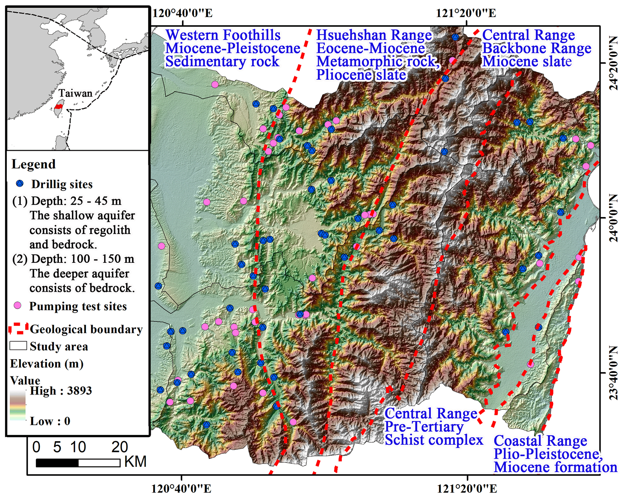
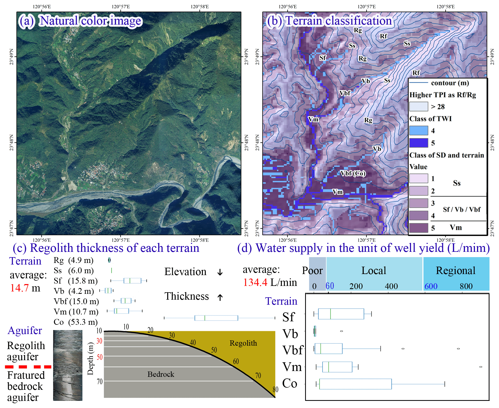
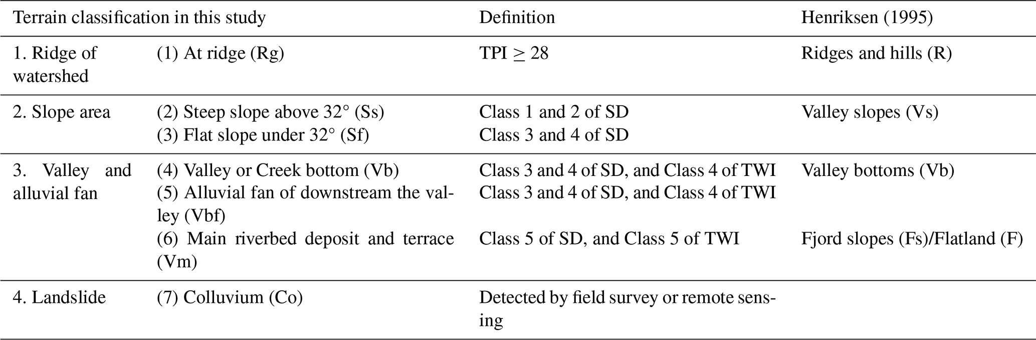
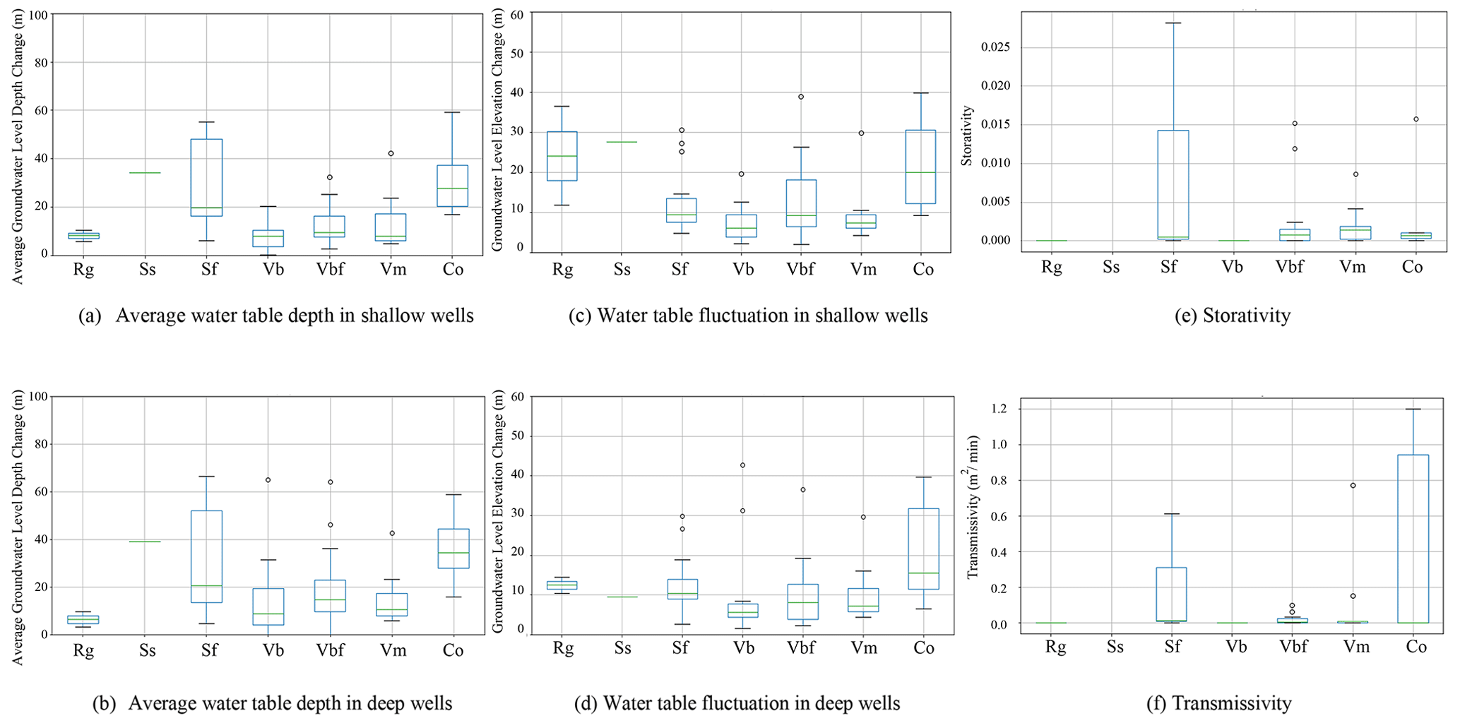
In groundwater resource management, the hydrogeological framework significantly influences groundwater flow and storage. The complexity of groundwater systems in orogenic regions necessitates comprehensive investigations. To ensure sustainable groundwater management and address global climate change impacts, hydrogeological surveys and long-term monitoring at the catchment scale are essential. However, regional surveys are often limited by budget constraints and field accessibility. Therefore, integrating remote sensing and GIS technology to analyze terrain features, combined with field test results, facilitates the establishment of comprehensive terrain classifications and groundwater potential maps, aiding subsequent groundwater resource investigations and management. This study collected data from 75 field investigation sites spanning the mountainous to plain regions of central Taiwan at the catchment scale. The data included regolith thickness, hydraulic parameters, and nearly ten years of groundwater level observations. Terrain classifications were based on indices such as the topographic wetness index, topographic position index, and slope degree, resulting in seven distinct terrain types. The results revealed that in main riverbed deposits and flat slopes, there were higher average well yields and groundwater-level fluctuations. Greater fluctuations were observed in areas characterized by ridges, colluvium, and low elevation in slope areas and valleys. The variability in shallow aquifers was particularly pronounced, with outliers reaching higher levels in slope and valley terrains. These findings underscore the complexity of groundwater dynamics in diverse terrain types, highlighting the need for tailored management strategies to ensure sustainable groundwater resources.

https://adgeo.copernicus.org/articles/64/13/2024/adgeo-64-13-2024-f01

Figure 1Topography and geology of the study area and locations of drilling sites and pumping tests for regolith and well yield data.

1 Introduction

Groundwater flow is inherently complex, forming local, intermediate, and regional flow systems influenced by various factors. Topographic terrain plays a crucial role in shaping these flow systems (Henriksen, 1995; Grinevskii, 2014; Dai et al., 2021). In bedrock regions, groundwater flow is primarily controlled by the hydrogeological framework and fracture networks (Chou et al., 2014; Chandra et al., 2019). Conducting field investigations for groundwater exploration is often prohibitively expensive, necessitating cost-effective methods. Integrating remote sensing and GIS techniques offers a viable solution for exploring groundwater resources efficiently. Terrain analysis, in particular, has become a globally recognized application in this context (Lin and Liou, 2020; Derdour et al., 2022). This study focuses on evaluating terrain-based groundwater potential and establishing long-term groundwater monitoring systems at the catchment scale in central Taiwan (Fig. 1). Unlike previous studies, it integrates terrain analysis with continuous groundwater level monitoring, providing a comprehensive understanding of groundwater dynamics. By combining terrain analysis with extensive field investigation data, including regolith thickness, hydraulic parameters, and groundwater level observations over nearly a decade, we aim to develop detailed groundwater potential maps and terrain classifications. The integration of remote sensing and GIS technology allows for a comprehensive assessment of the hydrogeological framework, aiding in the sustainable management of groundwater resources. Our methodology utilizes indices such as the topographic wetness index (TWI), topographic position index (TPI), and slope analysis for terrain classification. Additionally, we incorporate soil moisture index and soil moisture content derived from remote sensing data to assess groundwater recharge potential. This integrated approach yields valuable insights into the relationship between terrain characteristics and groundwater potential (Fig. 2), crucial for addressing the challenges posed by global climate change and ensuring the long-term sustainability of groundwater resources.

https://adgeo.copernicus.org/articles/64/13/2024/adgeo-64-13-2024-f02

Figure 2Terrain classification samples and corresponding hydrogeological investigation results in the study area.

2 Methodology

2.1 Terrain GIS Analysis

Terrain analysis utilized natural breaks to classify TWI, TPI, and slope degree (SD) into five classes, derived from a 30 m × 30 m digital elevation model using ArcGIS Raster Calculator. These indices facilitated the classification of the landscape into terrain types (Table 1 and Fig. 2). Additionally, colluvium was identified through drilling or landslide features detected by field surveys and remote sensing imagery.

2.2 Remote Sensing Analysis

Remote sensing involved obtaining soil moisture indices from Landsat imagery (Toby, 2007) and soil moisture content using the apparent thermal inertia (ATI) approach with Moderate Resolution Imaging Spectroradiometer (MODIS) imagery for analysis (Chang et al., 2012). These indices provided spatial and temporal information on soil moisture in remote areas.

2.3 Correlation Analysis

Field data from 75 groundwater wells, encompassing measurements of regolith thickness, hydraulic parameters, and observations of shallow and deep water tables (since 2010), were integrated with terrain analysis. Statistical analyses were performed to examine the correlation between terrain characteristics, soil moisture, and groundwater level fluctuations.

Table 1Terrain classification and literature.

Download Print Version | Download XLSX

3 Findings

The results showed that regolith thickness ranged from 0.5 to 80.8 m (Fig. 2), varying by terrain type. Although average water tables are similar in shallow and deep wells, fluctuations ranged from 2.04 to 39.71 m in shallow wells and 1.64 to 29.62 m in deep wells (Fig. 3). The greater variability in shallow wells suggests higher sensitivity to influences such as regolith distribution and recharge dynamics, whereas deep wells display more stable conditions due to lower permeability. Higher average well yields and groundwater fluctuations were notably observed in main riverbed deposits (Vm) and flat slopes (Sf) compared to soil moisture and hydraulic parameters, as shown in Fig. 3e and f. These findings highlight the terrain-based groundwater potential and the critical role of groundwater-level fluctuations in groundwater dynamics.

https://adgeo.copernicus.org/articles/64/13/2024/adgeo-64-13-2024-f03

Figure 3Long-term groundwater-level monitoring (since 2010) and hydraulic parameters for each terrain. (a) Average water table depth in shallow wells. (b) Average water table depth in deep wells. (c) Water table fluctuation in shallow wells. (d) Water table fluctuation in deep wells. (e) Storativity. (f) Transmissivity.

Download

4 Conclusions

Our study emphasizes the critical role of terrain-based assessments in comprehending groundwater dynamics in central Taiwan. Specifically, flat slopes demonstrate elevated well yield potential alongside fluctuations in storativity and transmissivity, indicating substantial recharge and discharge potential. This underscores the intricate nature of groundwater processes across diverse terrains. Our integrated methodology, amalgamating terrain analysis with field investigations and remote sensing, furnishes invaluable insights for groundwater management. Future work can incorporate more remote sensing indices by downscaling or upscaling them to the same spatial resolution as the terrain. Continued monitoring and refinement of strategies are crucial for sustaining groundwater resources amidst changing environmental conditions.

Code availability

The mapping and analysis for this study were performed using Python and ArcGIS software. The specific Python libraries and GIS tools used include: pandas (for data manipulation), numpy (for numerical analysis), matplotlib (for plotting), geopandas (for spatial data manipulation), rasterio (for handling raster data), and ArcGIS (for advanced spatial analysis and mapping). These tools are widely available and can be accessed through their respective official websites: Python: https://www.python.org/ (last access: 24 July 2024), ArcGIS: https://www.esri.com/en-us/arcgis/about-arcgis/overview (last access: 24 July 2024).

Data availability

The underlying research data for this study is publicly accessible and can be found in the following repository: https://hydro.geologycloud.tw/map (Geological Survey and Mining Management Agency, Ministry of Economic Affairs (GSMMA, MOEA), 2024).

Author contributions

JJL: Conceptualization, Investigation, Methodology, Data analysis, Writing-Original draft preparation and editing. CHL: Investigation, Data interpretation, Writing-Review.

Competing interests

The contact author has declared that neither of the authors has any competing interests.

Disclaimer

Publisher's note: Copernicus Publications remains neutral with regard to jurisdictional claims made in the text, published maps, institutional affiliations, or any other geographical representation in this paper. While Copernicus Publications makes every effort to include appropriate place names, the final responsibility lies with the authors.

Special issue statement

This article is part of the special issue “Groundwater management in the context of global change: integrating innovative approaches (EGU2024 HS8.2.1 session)”. It is a result of the EGU General Assembly 2024, Vienna, Austria, 14–19 April 2024.

Acknowledgements

Jung-Jun Lin would like to express sincere gratitude to the Geological Survey and Mining Management Agency, Ministry of Economic Affairs (GSMMA, MOEA) for the financial support (grant no. B11245), and the database providers. Additionally, both authors sincerely thank the reviewers for their time and constructive feedback, which significantly improved the quality of this article.

Financial support

This research has been supported by the Geological Survey and Mining Management Agency, Ministry of Economic Affairs (GSMMA, MOEA) (grant no. B11245).

Review statement

This paper was edited by Estanislao Pujades and reviewed by Paolo Colombo and one anonymous referee.

References

Chandra, S., Auken, E., Maurya, P. K., Ahmed, S., and Verma, S. K.: Large scale mapping of fractures and groundwater pathways in crystalline hardrock by AEM, Sci. Rep., 9, 398, https://doi.org/10.1038/s41598-018-36153-1, 2019. 

Chang, T.-Y., Wang, Y.-C., Feng, C.-C., Ziegler, A. D., Giambelluca, T. W., and Liou, Y.-A.: Estimation of root zone soil moisture using apparent thermal inertia with MODIS Imagery over a tropical catchment in Northern Thailand, IEEE J.-STARS, 5, 752–761, https://doi.org/10.1109/JSTARS.2012.2190588, 2012. 

Chou, P.-Y., Lin, J.-J., Hsu, S.-M., Lo, H.-C., Chen, P.-J., Ke, C.-C., Lee, W.-R. Huang, C.-C., Chen, N.-C., Wen, H.-Y., and Lee, F.-M.: Characterising the spatial distribution of transmissivity in the mountainous region: Results from watersheds in central Taiwan, in: Fractured Rock Hydrogeology, edited by: Sharp, J. M., CRC Press, London, UK, 115–127, https://doi.org/10.1201/b17016, 2014.  

Dai, X., Xie, Y., Simmons, C. T., Berg, S., Dong, Y., Yang, J., Love, A. J., Wang, C., and Wu, J.: Understanding topography-driven groundwater flow using fully-coupled surface-water and groundwater modeling, J. Hydrol., 594, 125950, https://doi.org/10.1016/j.jhydrol.2020.125950, 2021. 

Derdour, A., Benkaddour, Y., and Bendahou, B.: Application of remote sensing and GIS to assess groundwater potential in the transboundary watershed of the Chott-El-Gharbi, Appl. Water Sci., 12, 136, https://doi.org/10.1007/s13201-022-01663-x, 2022. 

Geological Survey and Mining Management Agency, Ministry of Economic Affairs (GSMMA, MOEA): Taiwan Hydrogeological Information System, GSMMA, MOEA [data set], https://hydro.geologycloud.tw/map, last access: 24 July 2024. 

Grinevskii, S. O.: The effect of topography on the formation of groundwater recharge, Moscow Univ. Geol. Bull, 69, 47–52, https://doi.org/10.3103/S0145875214010025, 2014. 

Henriksen, H.: Relation between topography and well yield in boreholes in crystalline rocks, Sogn og Fjordane, Norway, Groundwater, 33, 635–643, https://doi.org/10.1111/j.1745-6584.1995.tb00319.x, 1995. 

Lin, J.-J. and Liou, Y.-A.: Integrating in-situ data and RS-GIS techniques to identify groundwater potential sites in mountainous regions of Taiwan, Appl. Sci., 10, 4119, https://doi.org/10.3390/app10124119, 2020. 

Toby, C.: An overview of the “triangle method” for estimating surface evapotranspiration and soil moisture from satellite imagery, Sensors, 7, 1612–1629, https://doi.org/10.3390/s7081612, 2007. 

Download
Short summary
Our study addresses the challenges of costly groundwater investigation in the catchments by integrating in-situ groundwater data with terrain classification. This approach allows us to identify terrain-based groundwater potential and characterize groundwater levels. We aim for our findings to guide ongoing researchers in planning more detailed studies within their respective areas. These insights contribute to sustainable groundwater management and resource planning in similar topographies.