 | 20 Dec 2022
Modelling of groundwater recharge in the megacity of Lagos, Nigeria: preliminary results using WetSpass-M
Oluwaseun Franklin Olabode
Jean-Christophe Comte
Lagos, Nigeria is one of the World's fastest-growing cities. The increasing water demand has led to depletion and deterioration of the groundwater resources contained in its highly productive coastal aquifers. Groundwater recharge processes and drivers, which dictate groundwater replenishment, and their changes associated with rapid urbanization, are yet to be quantified and understood. We used the spatially distributed WetSpass-M model to estimate the spatiotemporal patterns and rates of recharge between 2000 and 2020 in the 5440 km2 coastal aquifer system underlying the megacity of Lagos. The influence of expanding urban areas, from 807 km2 in 2000 to 1183 km2 in 2020, coincide with reduction in the simulated recharge by 50 % in 20 years. The study also revealed diffuse and focused recharge processes associated with, respectively, the urban centres and areas closer to water bodies signalling strong groundwater-surface water interactions. The preliminary findings from this modelling work provide directions for exploring sustainable water management options including Managed Aquifer Recharge (MAR) in Lagos and other fast-growing coastal megacities in the world.
- Article
(2230 KB) - Full-text XML
- BibTeX
- EndNote


The human population in Lagos has geometrically grown from 325 000 people in 1950 to more than 15 million human people in recent year 2020, with a current annual population growth rate of 3.5 %. This, ranks Lagos in the World's top 10 fastest-growing megacities (Hoornweg and Pope, 2017). Some authors predict Lagos will be the most populous city in the world by 2100 (Desjardins, 2018). Growing human population coupled with insufficiently resourced water governance have aggravated the water availability crisis in the city (Jideonwo, 2014; Balogun et al., 2017). Currently, the city is struggling with a widening water demand-supply gap of 54.47 million L d−1 (Lagos Water Corporation, 2010). Water supply is highly dependent on groundwater resources which are supporting water needs of the approximately 90 % of the Lagos population (Healy et al., 2020). Evidence of aquifer depletion, saltwater intrusion, and contamination of groundwater attributed to groundwater over-abstraction and anthropogenic activities (wastewater discharge) have been reported (Ola et al., 2019; Oladapo et al., 2014).
An assessment of the natural replenishment (i.e. recharge) of the coastal aquifers systems, and its evolution under rapid urbanisation, should be given close attention in order to assess the capacity of the aquifer to sustainably support the increasing population. Groundwater recharge is challenging to measure directly, leading to an inherent uncertainty when trying to develop aquifer budgets, investigate groundwater vulnerability and migration of nutrients or contaminants, and determine the impact of changes in land cover and climate (Smerdon, 2017). In Lagos, the impacts of climate change and growing human activities on groundwater recharge in Lagos remain unknown to date.
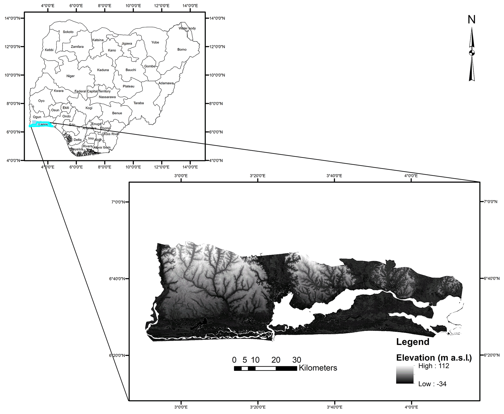
Figure 1Location of the Lagos aquifer system on the Southwestern coast of Nigeria, West Africa.
This study aims at conceptualising and quantifying groundwater recharge processes and evolution in the coastal aquifer system underlying the growing Lagos agglomeration (Fig. 1). To achieve this, land-use transitions over the regional coastal aquifer domain were mapped for the years 2000 and 2020 using remote sensing datasets. Groundwater recharge and its changes as a results of urban expansion were then assessed using the WetSpass-M model (a widely used physical-based spatially distributed water balance model) (Abdollahi et al., 2017) and put in perspective with the increasing water demand in the megacity.
2.1 Land use transition
Land cover images representative for the years (2000 and 2019), as obtained from Global Land Cover 1992–2019 (ESA, 2017), were reclassified into three classes: vegetated cover, open water and built-up areas. The index of all the land classes was carefully examined. Indices showing related features to the different land use classes (vegetation, water bodies and the urban regions) were merged together in the edit tool of ArcGIS environment. The coverage area (surface area) for the reclassified land-use classes was computed in the ArcGIS environment.
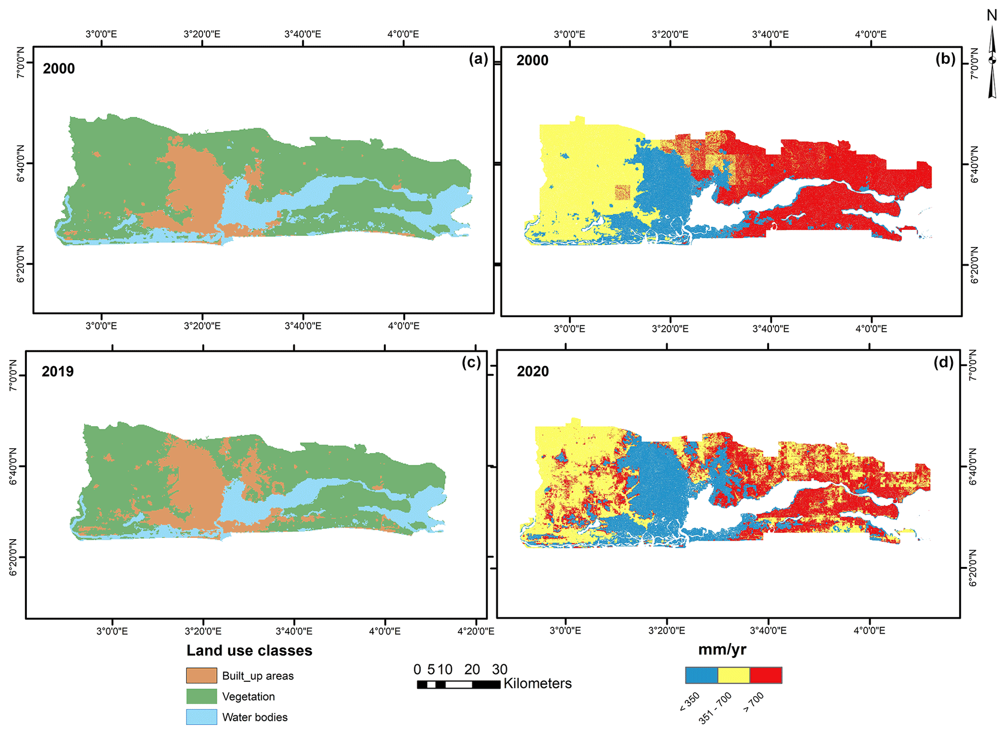
Figure 2(a, c) Input Land use maps for 2000 and 2019 and (b, d) simulated recharge for 2000 and 2020 illustrating the rapid increase in urban surfaces at the expense of vegetated surfaces and general decrease of recharge as urban areas expand.
2.2 Simulation of groundwater recharge with estimated water demand in Lagos
The WetSpass-M Model (Vrije Universiteit Brussels, Belgium; available at https://github.com/WetSpass, last access: 13 December 2022), which is a spatially distributed monthly water balance model, was utilized to simulate the water balance components between the years (2000 and 2020). WetSpass-M is a raster-based model that partitions precipitation into interception, surface runoff, evapotranspiration, and recharge for each grid cell (Abdollahi et al., 2017). Groundwater recharge is obtained as residual from the water balance for each raster cell. Primary input datasets included spatially distributed/reclassified land use for the years (2000 and 2019), soil texture, slope, digital elevation model (DEM), and monthly climatic data (rainfall, potential evapotranspiration, number of rainy days, wind, and temperature) and groundwater depth for the years 2000 and 2020 (Funk et al., 2015; Singer et al., 2021). These datasets were sourced from Global Land Cover 1992–2019 overview, FAO, Shuttle Radar Topography Mission (SRTM), CHIRPS dataset, ERA5 reanalysed data, and NASA POWER respectively. Four sub-cell fractions were defined per model grid cell for each of the land-use classes (vegetated cover, bare soil, open water, and impervious surface). The differentiation of the grids will address land-use heterogeneity within the cell (Abdollahi et al., 2017; Siddik et al., 2022). Because datasets have different spatial resolutions, this required resampling of the generated maps into 60 m × 60 m resolution grid cells in ArcGIS, making 809 rows and 2551 columns for the total of 761 350 raster cells. The model was run for 12 monthly time steps for each year, yielding the final model outputs: monthly groundwater recharge, runoff, evapotranspiration, and an interception for the years 2000 and 2020. The model assumed that water bodies have no groundwater recharge.
The total water consumption was calculated by summing the daily water quantities required for various water usages such as industrial use, domestic or public use, fire use, waste of water. The estimated total water consumption stand as 320 L d−1 in Lagos. The Wetspass-M model outputs, i.e. monthly recharge were subsequently summed up to total annual values and plotted alongside estimated water demand in 2000 and 2020 for comparisons.
The transition of different land-use categories (vegetation, open water, and built-up areas/urban areas) for years between 2000 and 2019 are shown in Fig. 2a and c. Between 2000 and 2019, the surfaces of water bodies and vegetation have decreased significantly from 982 to 926 km2 (−6 %) and 3650 to 3330 km2 (−9 %), respectively. Built-up areas have recorded an increase from 807 to 1183 km2 (+50 %) due to the increasing human population, industrialization and expansion of Lagos. The rapid urbanization experienced in Lagos appears similar in several cities such as Nairobi, Dhaka, Moscow, Tokyo, Chengdu etc (Oiro et al., 2020; Sun et al., 2020). Urbanisation has been accompanied by drilling boreholes/wells to meet the increasing human population, which has led to acute water shortage arising from over-abstraction of groundwater from the coastal aquifers system, with looming problems such as saline water intrusion, wastewater discharge, and leakage of contaminants (Adiat, 2019; Ajani et al., 2021; Akoteyon et al., 2018; Balogun et al., 2017; Oloruntola et al., 2017; Tijani et al., 2018).
Spatially, the central part of the Lagos region received a lower recharge than the western and eastern, due to extensive built-up areas associated with altered soils and constructed surfaces (compacted gravels, compacted laterite, tar, concrete, etc.), whereas vegetated surface elsewhere are associated with well drained sandy soils. Diffuse groundwater recharge processes characterize the urban centers while focused groundwater recharge associated with the hydrological drainage network (rivers and streams) prevails in areas close to the water bodies. These findings agree with previous isotopic studies suggesting recent recharge from precipitation (Yusuf et al., 2018) and strong groundwater-surface water interaction in the vicinity of the lagoon areas in Lagos (Ayolabi et al., 2013). The model results show an average 30 % of precipitation potentially infiltrates and recharges the coastal aquifer of Lagos.
Over time, i.e. over the two decades period between 2000 and 2020, models results show an overall reduction in infiltrating water alongside and increase in runoff waters and flood water in the Lagos region, which is consistent with the results obtained from land use/land classes transitions (Fig. 2b, d). When comparing with water demand in Lagos agglomeration (Fig. 3), water demand in 2000 represented about a quarter of the total aquifer recharge where in 2020 the demand has rised to about half of the modelled recharge. When spatially limiting the analysis to the urban recharge, where in 2020 it exceeds the urban recharge by about 20 %. At these rates of increasing demand and decreasing recharge, it can be extrapolated that in a couple of decade groundwater resources will no longer be able to meet demand sustainable, and confirms that depletion which is already occurring in Lagos agglomeratoion may accelerate and extend to the entire aquifer. In this context, artificial aquifer replenishment, such as managed aquifer recharge using the increasing runoff could be a solution to slow down or stabilise these trends and contribute to more sustainable groundwater use.
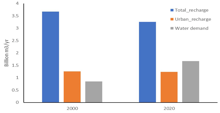
Figure 3Comparison of simulated recharge over the entire aquifer domain and over the Lagos-urban with water demand for the years 2000 and 2020.
In most (mega)cities, rapid urban transformation has occurred in the past decades due to increasing human population and industrial activities. This is likely to continue over the next decades particularly in developing countries when demographic growth rates are highest. In Lagos, groundwater resources have become the most dependable resource in meeting the megacity's growing water needs; however to date no consideration was given to the groundwater resources renewability required to sustainably meet the increased demand. The recharge estimates and trends provided from this study show that over the last two decades, water demand has overtaken the recharge rate over the urban agglomeration and is now rapidly converging towards the total aquifer recharge rate. These results are important to inform and guide a more sustainable groundwater development and water management decisions. It is recommended in particular to explore the potential for Managed Aquifer Recharge to address recharge decline and increase groundwater availability as a sustainable water management option in Lagos megacity. Groundwater numerical modelling is urgently needed to better understand flow and transport in the coastal aquifer system and explore management scenarios involving managed aquifer recharge and abstraction optimisation.
WetSpass-M code is publicly available at: https://github.com/WetSpass/WetSpass-M (last access: 13 December 2022; Abdollahi et al., 2017; https://doi.org/10.1007/s12665-017-6512-1). There is no publicly available data for this paper.
OFO and JCC conceptualized the research and defined the methodology. OFO implemented the modelling. OFO and JCC analysed and validated the results. OFO wrote the original draft of the paper. JCC contributed to the writing, reviewing and editing of the paper. OFO obtained the scholarship which funded this research.
The contact author has declared that neither of the authors has any competing interests.
Publisher's note: Copernicus Publications remains neutral with regard to jurisdictional claims in published maps and institutional affiliations.
This article is part of the special issue “Quality and quantity issues in urban hydrogeology (EGU2022 HS8.2.8 session)”. It is a result of the EGU General Assembly 2022, Vienna, Austria, 23–27 May 2022.
This research has been supported by the Nigerian Tertiary Education Trust Fund (TETFUND) which sponsored the first author's PhD studies at the University of Aberdeen, Scotland UK. Authors thank Syed Mustafa for advices during WetSpass-M installation and learning process.
This research has been supported by the Tertiary Education Trust Fund (grant no. TETF/ES/UNIV/ONDO/TSAS/2018).
This paper was edited by Estanislao Pujades and reviewed by Anna Jurado Elices and Sonia Valdivielso.
Abdollahi, K., Bashir, I., Verbeiren, B., Harouna, M. R., Van Griensven, A., Huysmans, M., and Batelaan, O.: A distributed monthly water balance model: formulation and application on Black Volta Basin, Environ. Earth Sci., 76, 198, https://doi.org/10.1007/s12665-017-6512-1, 2017 (code available at: https://github.com/WetSpass/WetSpass-M, last access: 13 December 2022).
Adiat, K. A. N.: Application of Geophysical Borehole Logs For Aquifer Characterization in Coastal Environment of Lagos, Southwestern Nigeria, Niger. J. Basic Appl. Sci., 26, 31–45, https://doi.org/10.4314/njbas.v26i1.4, 2019.
Ajani, G. E., Popoola, S. O., and Oyatola, O. O.: Evaluation of the Pollution Status of Lagos Coastal Waters and Sediments, using Physicochemical Characteristics, Contamination Factor, Nemerow Pollution Index, Ecological Risk and Potential Ecological Risk Index, Int. J. Environ. Clim. Chang., 13, 1–16, https://doi.org/10.9734/ijecc/2021/v11i330371, 2021.
Akoteyon, I. S., Balogun, I. I., and Soneye, A. S. O.: Integrated approaches to groundwater quality assessment and hydrochemical processes in Lagos, Nigeria, Appl. Water Sci., 8, 1–19, https://doi.org/10.1007/s13201-018-0847-y, 2018.
Ayolabi, E. A., Folorunso, A. F., Odukoya, A. M., and Adeniran, A. E.: Mapping saline water intrusion into the coastal aquifer with geophysical and geochemical techniques: The University of Lagos campus case (Nigeria), Springerplus, 2, 1–14, https://doi.org/10.1186/2193-1801-2-433, 2013.
Balogun, I. I., Sojobi, A. O., and Galkaye, E.: Public water supply in Lagos State, Nigeria: Review of importance and challenges, status and concerns and pragmatic solutions, Cogent Eng., 4, 1329776, https://doi.org/10.1080/23311916.2017.1329776, 2017.
Desjardin, J.: Mapping the world’s New Megacity in 2030, Mapped: Where The World's Biggest Megacities Will Be in 2030, https://www.visualcapitalist.com/mapping-the-worlds-new-megacities-in-2030/ (last access: 13 December 2022), 2018.
ESA: Land Cover CCI Product User Guide Version 2, Tech. Rep., https://maps.elie.ucl.ac.be/CCI/viewer/download/ESACCI-LC-Ph2-PUGv2_2.0.pdf (last access: 13 December 2022), 2017.
Funk, C., Peterson, P., Landsfeld, M., Pedreros, D., Verdin, J., Shukla, S., Husak, G., Rowland, J., Harrison, L., Hoell, A., and Michaelsen, J.: The climate hazards infrared precipitation with stations – A new environmental record for monitoring extremes, Sci. Data, 2, 1–21, https://doi.org/10.1038/sdata.2015.66, 2015.
Healy, A., Upton, K., Capstick, S., Bristow, G., Tijani, M., Macdonald, A., Goni, I., Bukar, Y., Whitmarsh, L., Theis, S., Danert, K., and Allan, S.: Domestic groundwater abstraction in Lagos, Nigeria: A disjuncture in the science-policy-practice interface?, Environ. Res. Lett., 15, 45006, https://doi.org/10.1088/1748-9326/ab7463, 2020.
Hoornweg, D. and Pope, K.: Population predictions for the world's largest cities in the 21st century, Environ. Urban., 29, 195–216, https://doi.org/10.1177/0956247816663557, 2017.
Jideonwo, J. A.: Ensuring Sustainable Water Supply in Lagos, Nigeria, MSc thesis, University of Pennsylvania, Penn Library, Philadelphia, 161 pp., 2014.
Lagos Water Corporation (LWC): Lagos Water Supply Master Plan, LWC document, 35 pp., 2010.
Oiro, S., Comte, J. C., Soulsby, C., MacDonald, A., and Mwakamba, C.: Depletion of groundwater resources under rapid urbanisation in Africa: recent and future trends in the Nairobi Aquifer System, Kenya, Hydrogeol. J., 28, 2635–2656, https://doi.org/10.1007/s10040-020-02236-5, 2020
Ola, S. A., Fadugba, O. G., Adekoya, J. A., Babatola, J. O., Ajayi, O. O., Ojuri, O. O., and Akinde, S. B.: Petroleum hydrocarbon contaminated groundwater remediation using 21st century technology: Baruwa community, Lagos State Nigeria as a case study, IOP Conf. Ser. Mater. Sci. Eng., 640, 012090, https://doi.org/10.1088/1757-899X/640/1/012090, 2019.
Oladapo, M. I., Ilori, O. B., and Adeoye-Oladapo, O. O.: Geophysical study of saline water intrusion in Lagos municipality, African J. Environ. Sci. Technol., 8, 16–30, https://doi.org/10.5897/ajest2013.1554, 2014.
Oloruntola, M. O., Bayewu, O. O., Mosuro, G. O., Folorunso, A. F., and Ibikunle, S. O.: Groundwater occurrence and aquifer vulnerability assessment of Magodo Area, Lagos, Southwestern Nigeria, Arab. J. Geosci., 10, 110, https://doi.org/10.1007/s12517-017-2914-3, 2017.
Siddik, M. S., Tulip, S. S., Rahman, A., Islam, M. N., Haghighi, A. T., and Mustafa, S. M. T.: The impact of land use and land cover change on groundwater recharge in northwestern Bangladesh, J. Environ. Manage., 315, 115130, https://doi.org/10.1016/j.jenvman.2022.115130, 2022.
Singer, M. B., Asfaw, D. T., Rosolem, R., Cuthbert, M. O., Miralles, D. G., MacLeod, D., Quichimbo, E. A., and Michaelides, K.: Hourly potential evapotranspiration at 0.1∘ resolution for the global land surface from 1981–present, Sci. Data, 8, 1–13, https://doi.org/10.1038/s41597-021-01003-9, 2021.
Smerdon, B. D.: A synopsis of climate change effects on groundwater recharge, J. Hydrol., 555, 125–128, https://doi.org/10.1016/j.jhydrol.2017.09.047, 2017.
Sun, L., Chen, J., Li, Q., and Huang, D.: Dramatic uneven urbanization of large cities throughout the world in recent decades, Nat. Commun., 11, 5366, https://doi.org/10.1038/s41467-020-19158-1, 2020.
Tijani, M. N., Adekoya, A.E., Fashae, O. A., Tijani, S. A., and Aladejana, J.: Land-Use Changes And Urbanization Impacts on Livelihood and Groundwater Sustainability of Coastal Areas of Lagos, SW-Nigeria : Integrated GIS-based, Livelihood and Hydrochemical Assessments, Journal of Mining and Geology, 54, 187–202, 2018.
Yusuf, M. A., Abiye, T. A., Butler, M. J., and Ibrahim, K. O.: Origin and residence time of shallow groundwater resources in Lagos coastal basin, south-west Nigeria: An isotopic approach, Heliyon, 4, e00932, https://doi.org/10.1016/j.heliyon.2018.e00932, 2018.