Articles | Volume 59
https://doi.org/10.5194/adgeo-59-45-2022
14 Dec 2022
 | 14 Dec 2022

The CASPER project: an integrated approach for pollution risk assessment in peri-urban groundwater catchment areas

Serge Brouyère, Laura Balzani, and Philippe Orban
Abstract

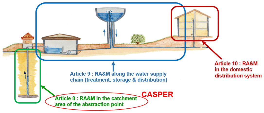
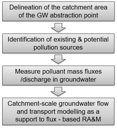
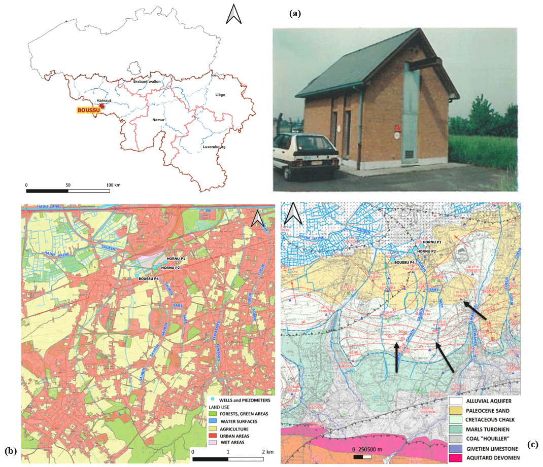
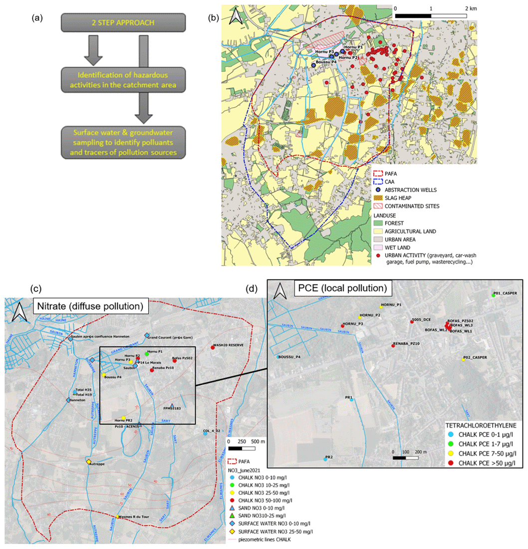
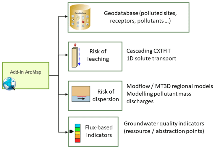
In 2020, the European Union has established a recast of the 1998 EU Directive on the quality of water intended for human consumption, hereafter called Drinking Water Directive – DWD. One of the most significant innovative point in this recast is the introduction of an innovative “complete risk-based approach to water safety, covering the whole supply chain from the catchment area, abstraction, treatment, storage and distribution to the point of compliance” (article 7). In practice, a 3-level risk assessment and risk management is expected: (1) at the level of the catchment area (article 8), (2) at the level of the water supply systems (article 9) and (3) at the level of the domestic distribution system (article 10). In this context, the CASPER project, funded by SPGE in the Walloon Region of Belgium, aims at developing an integrated approach for the evaluation and management of pollution risks for peri-urban groundwater catchments. The approach, which fully complies with the requirements of the DWD recast, consists of several key components. First, point and diffuse pollution sources are identified in the groundwater catchment area based on a mapping of hazardous activities combined with a specific groundwater monitoring survey aiming at identifying specific tracers of such sources of pollution. In a second step, risks associated to each of the identified source of pollution is estimated based on the measurement of pollutant mass fluxes and mass discharges downgradient these sources. Finally, a groundwater flow and transport model is developed at the scale of the groundwater catchment area, with the aim of evaluating the cumulative effect of the multiple sources on groundwater quality deterioration in the catchment and at the abstraction points. The objective here is to describe the CASPER approach and to illustrate it using ongoing investigations in a peri-urban groundwater catchment exploiting groundwater from a chalk aquifer in Western Belgium.

1 Introduction

In December 2020, the European Union has established a recast (Directive 2020/2184) of the 1998 EU Directive on the quality of water intended for human consumption (Directive 98/83/CE), hereafter called Drinking Water Directive – DWD. Four main areas were identified as offering scope for improvement, namely the list of quality-based parametric values, the limited reliance on a risk-based approach, the imprecise provisions on consumer information, and the disparities between approval systems for materials that come into contact with water intended for human consumption and the implications such disparities have for human health. In addition, the Right2Water initiative identified as a distinct problem the fact that part of the population, in particular marginalised groups, has no access to water intended for human consumption, and providing such access is a commitment under Goal 6 of the Sustainable Development Goals (SDGs) of the United Nations 2030 Agenda for Sustainable Development. One of the most significant modifications relates to Article 7 which promotes a complete risk-based approach for water safety, all along the water supply chain from where it is abstracted to where it is delivered as drinking water. It consists in fact in a 3-level risk assessment and management/monitoring process (RA&M), with Article 8 defining the requirements for risk assessment and management in the catchment area of the abstraction point, Article 9 doing the same all along the water supply chain and Article 10 focusing on the domestic distribution system (Fig. 1).

https://adgeo.copernicus.org/articles/59/45/2022/adgeo-59-45-2022-f01

Figure 1The three main areas developed on the new approach of Risk Assessment and Monitoring (RA&M) of groundwater quality (Source image: adapted from Tom Schaul​​​​​​​, Ministry of Environment Luxembourg).

Article 8 has direct implications for groundwater (GW) as it considers risk assessment and management in the catchment areas of groundwater abstraction points of water intended for human consumption. In particular, Article 8 specifies that Member States have to ensure that the risk assessment procedure includes the following elements:

  1. the identification and mapping of the catchment area of the abstraction points;

  2. mapping of the safeguard zones, where those zones have been established;

  3. a georeferencing for all abstraction points in the catchment areas;

  4. the description of land-use, runoff, and recharge processes in the catchment areas.

In addition, the identification of hazards and hazardous events in the catchment areas should be undertaken and the associated risk of deterioration of the quality of the concerned water should be evaluated.

Finally, an appropriate monitoring of surface water and/or groundwater in the catchment areas, or in raw water should be established of relevant and selected parameters, substances, pollutants and either naturally occurring substances that could constitute a potential danger for human health (e.g., parameters in Parts A and B of Annex I of this Directive, Annex I and II of Directive 2006/118/EC, Annex I to Directive 2008/105/EC, Directive 2000/60/EC, Ground Water Watch List 2019, new emerging organic contaminants like endocrine-disrupting compounds as Bisphenol-A , and also micro-organisms/bacteria, etc.). Such a monitoring should involve not only harmful chemicals parameters, but also indicator parameters, which have no direct public health impact but are important as a means of determining how production and distribution facilities for water intended for human consumption are functioning.

2 The CASPER methodology

2.1 General objectives

In this context, the CASPER project, financed by SPGE in the Walloon Region of Belgium, aims at developing an integrated approach for the evaluation and management of pollution risks for urban and sub-urban groundwater catchments (see Fig. 1). In sub-urban areas, groundwater catchments are potentially exposed to various overlapping point and diffuse pollution sources. Thus, there is a need to use specific tools for the evaluation and manage of the risk of the different kind of groundwater contaminations.

The newly developed approach fully complies with the requirements of the DWD recast as it consists of the following 4 main steps summarized by the flowchart in Fig. 2 and described in more details afterwards.

https://adgeo.copernicus.org/articles/59/45/2022/adgeo-59-45-2022-f02

Figure 2Integrated approach of peri-urban sites investigation (GW = groundwater; RA&M, Risk Assessment and Management).

Download

https://adgeo.copernicus.org/articles/59/45/2022/adgeo-59-45-2022-f03

Figure 3(a) Localisation, (b) land use (source: © WalOnMap), and (c) hydrogeological map of the study area (background map: Carte Quiévrain – Saint-Ghislain_4556).

A case study has been selected as a support to the developments undertaken in the CASPER methodology with investigations undertaken in a peri-urban groundwater catchment located in the chalk aquifer of the Haine basin in Western Belgium. More precisely, the study area is located in the municipality of Boussu (Fig. 3a). Land use (Fig. 3b) consists of a mixture of urban-industrial and agricultural areas meaning the groundwater contamination potentially consists of a mixture of pollutants from various origins. Hydrogeologically speaking, two aquifers can be identified in the area (Fig. 3c): the aquifer unit of the Quaternary alluvium and Tertiary sands (groundwater body BERWE031), and the lower aquifer located in the Lower Cretaceous chalk corresponding to the groundwater body (groundwater body BERWE030). The latter is the one exploited by the studied wells. Groundwater flows globally from south to north.

2.2 Delineation of the catchment area of the abstraction

The first step of the CASPER approach consists of delineating the Catchment Area of the Abstraction (CAA) was delimited (Fig. 4). This corresponds to the land surface area corresponds to any location from where a pollution that occurs is likely to reach the abstraction point. So, this is the area of interest to investigate on any risk of groundwater pollution that could occur today or later in the future.

https://adgeo.copernicus.org/articles/59/45/2022/adgeo-59-45-2022-f04

Figure 4Methodology for the delineation of the catchment area of the abstraction point (a) on the left, in particular of the CAA – catchment area of the abstraction and the PAFA – part of aquifer feeding the abstraction, and its application to the CASPER case study (b) on the right, with map Carte Quiévrain – Saint-Ghislain_4556 as background.

According to the methodology proposed by Guisado (2015), Vernoux et al. (2014), and Vandenberghe et al. (2015), the delineation of the CAA is first based on various hydrogeological information (piezometry, radius of influence of pumping wells etc.) which allow to delineate the Part of Aquifer Feeding the Abstraction, PAFA (i.e. the subsurface capture zone of the groundwater abstraction point). The PAFA is then projected on the land surface and extended to include any location that may discharge pollutants to groundwater either by direct infiltration or by runoff first followed by infiltration. This is illustrated with a theoretical cross-section (Fig. 4a) and the map resulting PAFA and CAA for the CASPER case study (Fig. 4b). Figure 4b also indicates the groundwater protection (safeguard) zones that were initially delineated for the same catchment based on 24 h and 50 d travel times of pollutants in groundwater. The CAA extends over a much larger area, which indicates that efficient groundwater protection cannot be based solely on the safeguard zones since pollutants may come from locations outside these zones.

2.3 Identification of potential hazards and groundwater – surface water monitoring campaigns

Once the PAFA and the CAA are delineated, existing and potential point and diffuse pollution sources have to be identified in the CAA. A2-step procedure is used (Fig. 5a) :on one hand a cartography of hazardous activities in the catchment is drawn (Fig. 5b); on the other hand a specific groundwater – surface water monitoring network (sampling points and survey) is established, aiming at identifying pollutants and specific tracers of the identified various sources of pollution. Figure 5c and d illustrate the results of one of the campaigns undertaken in the studied catchment in for nitrate which is found almost everywhere in groundwater (left) and for perchloroethylene for which a large plume has been identified in the eastern part of the chalk aquifer.

https://adgeo.copernicus.org/articles/59/45/2022/adgeo-59-45-2022-f05

Figure 5Procedure for identification of potential and existing sources of groundwater pollution: (a) the 2-steps approach schema, (b) cartography of potential pollution sources, (c, d) spatial results of concentration of NO3 and Chlorinated Solvants (Landuse and Satellite images on backgrounds are from © WalOnMap).

2.4 Measurements of pollutant mass discharges for flux-based risk assessment

In a second step, risks associated to each of the identified source of pollution are estimated based on the measurement of pollutant mass fluxes and mass discharges downgradient these sources. This innovative approach relies on two main reasons. First, dangerous pollutants are those that actually migrate easily into groundwater. On the contrary, if the pollution does not move, there is no risk for downgradient receptors. Second, in the (frequent) case for which the location of the pollution source is not precisely known, one obtains at least an estimate of the pollutant flux and mass discharge downgradient from the location where the pollutant mass fluxes are measured. This allows better constraining the quantity of pollutant that further circulates in groundwater, which is useful for groundwater pollution risk assessment.

Without going into the details, pollutant mass fluxes are estimated as follows. A control panel made of several boreholes intercepting the pollutant plume is established. In each well, groundwater fluxes are measured using the single well FVPDM dilution method (Brouyère et al., 2008, 2018). This technique is a generalisation of the classical point dilution methods used to measure groundwater flow in boreholes. It is based on the monitoring of the evolution of the concentration of a tracer injected in a continuous way within the well. It requires one pump to inject the tracer at a precise low rate; and a second pump to mix the water column and ensure a homogeneous distribution of the tracer in the well. The monitoring of the tracer concentration in the well can be done with an in-line measurement unit placed directly in the well on the circulation loop. Quantification of the groundwater flow (and apparent Darcy's flux which depends on the characteristics of the well) is based on the observed dilution of the tracer in the well, which is compared to the concentration of the injected tracer. The resulting groundwater fluxes are multiplied by the concentrations measured in the same boreholes, giving pollutant mass flux estimates in each borehole. Finally, the pollutant mass fluxes are multiplied by the corresponding sections of the control panel to obtain a pollutant mass discharge.

2.5 GIS-based decision support system for regional scale flux-based risk assessment

The final step of the CASPER approach consists of developing a flux-based risk assessment framework at the regional scale following the approach proposed by Jamin et al. (2012). This allows considering the cumulative effect of multiple pollution sources located in catchment area and the potential global deterioration of groundwater in the catchment as a whole or at specific locations such as groundwater abstraction points. To reach that objective, an integrated GIS-based interface system has been developed with (Fig. 6):

  • a geodatabase that contains all relevant information on land use, hydrogeology and a series of layers of information on pollution sources and associated pollutants (activity-pollutant matrix, sources localisation, physicochemical properties of pollutants, etc.);

  • a calculation module to evaluate the risk of pollutant leaching from soils to groundwater (based on cascading analytical solutions of solute transport equations);

  • a module for evaluating the risk of dispersion of pollutants across groundwater (based on the Modflow-MT3D suite);

  • and a decision tool evaluating risks based on pollutant fluxes.

https://adgeo.copernicus.org/articles/59/45/2022/adgeo-59-45-2022-f06

Figure 6Framework of regional approach to assess and control the pollution risk associated with the cumulative effect of a series of pollution sources (adapted from Jamin et al., 2012; © HGE-Université de Liège 2022).

3 Conclusions and perspectives

In conclusion, few key concepts can be pointed out:

  • i.

    The CASPER methodology and tools are fully compliant with the 2020 recast of the Drinking Water Directive, and the investigations are undertaken at the scale of the groundwater catchment area.

  • ii.

    A dual/multiple approach is preferred for the identification of (potential) pollutants (specific substances, stable isotopes, bacteria abundance, etc.).

  • iii.

    One of the key concepts behind the approach is the flux-based risk assessment paradigm that allows considering the potential strength of pollution sources and their capacity to degrade significant volumes of groundwater.

  • iv.

    In the end a GIS-based decision support system allows integrating all data, measurements, and results into an efficient groundwater management platform at the scale of the catchment area.

In terms of perspectives first there are still different steps to be finalised for the first application on CASPER test site, mostly characterised by three main contaminations sources: nitrate (diffuse source, mainly from agriculture), sulphate (from slagheaps and anthropogenic inputs, therefore both diffuse and point sources), and chlorinated solvents (from which the source is still unknown). It is important to notice that pollutants sources tracking remains a challenge, especially in very complex cases, such this one, in which there are several mixed contamination sources.

In terms of future developments and research perspectives, one of the priorities should be to better integrate diffuse pollution sources in the risk assessment approach (which is presently better suited to manage point pollution scenarios) through the integration of a groundwater vulnerability assessment approach into the CASPER methodology. One promising option is to use the Apsû process groundwater vulnerability assessment method (Popescu et al. 2019), which evaluates groundwater vulnerability as a function of processes governing the fate of pollutants at the land surface (i.e. runoff, direct and lateral infiltration) and below ground (i.e. pollutant transport/attenuation in the subsurface). This makes it particularly compatible with the concepts developed in the CASPER approach.

Code availability

The code is not public. It was developed in the context of a former project and it is owned by SPAQuE.

Data availability

Data are not publicly accessible. For more information about underlying data, please contact the author.

Author contributions

All authors conceived of the presented idea. SB and PO designed the steps of the procedure. LB was in charge of gathering data in the field and processing them. All authors provided critical feedback and helped shape the research-analysis. All authors discussed the results and commented on the manuscript.

Competing interests

The contact author has declared that none of the authors has any competing interests.

Disclaimer

Publisher’s note: Copernicus Publications remains neutral with regard to jurisdictional claims in published maps and institutional affiliations.

Special issue statement

This article is part of the special issue “Quality and quantity issues in urban hydrogeology (EGU2022 HS8.2.8 session)”. It is a result of the EGU General Assembly 2022, Vienna, Austria, 23–27 May 2022.

Acknowledgements

The authors thank SPGE (Société Publique de Gestion de l'Eau) for the financement of the CASPER project. The authors also express their gratitude to SWDE (Société Wallonne Des Eaux), SPAQuE, the research unit of Aquapôle-ULiège and FMV-ULiège for their active participation to the CASPER project. We appreciate the constructive comments from the reviewers.

Financial support

This research has been supported by SPGE (grant no. DF08).

Review statement

This paper was edited by Estanislao Pujades and reviewed by two anonymous referees.

References

Brouyère, S., Batlle-Aguilar, J., Goderniaux, P., and Dassargues, A.: A New Tracer Technique for Monitoring Groundwater Fluxes: The Finite Volume Point Dilution Method, J. Contam. Hydrol., 95, 121–140, https://doi.org/10.1016/j.jconhyd.2007.09.001, 2008.  

Brouyère, S., Jamin, P., Orban, P., Dassargues, A., and Cosme, F.: Advanced single-well applied tracer techniques for improving reliability of groundwater and contaminant mass flux monitoring. Paper presented at Conference on Remediation of Chlorinated and Recalcitrant Compounds, 9–12 April 2018, Palm Springs, CA, USA, https://orbi.uliege.be/bitstream/2268/222316/2/D6_1210_%23422_Brouy%C3%A8re.pdf (last access: 20 July 2022), 2018. 

Guisado, A.: Réalisation d'une carte piézométrique et intérêts dans la délimitation des aires d'alimentation de captages, Mémoire de stage Supervisor Doney, C., MSc thesis, Université de Bourgogne, https://www.google.com/url?sa=t&rct=j&q=&esrc=s&source=web&cd=&ved=2ahUKEwjtorj1oOz7AhXOyaQKHVvPAwsQFnoECBMQAQ&url=https%3A%2F%2Fnuxeo.u-bourgogne.fr%2Fnuxeo%2Fsite%2Fesupversions%2F38411760-6b16-4802-b167-c8ddb9adac0d&usg=AOvVaw0PN5i8zuYy5cmiQtJPYRSI (last access: 9 December 2022), 2015. 

Jamin, P., Dollé, F., Chisala, B., Orban, P., Popescu, I. C., Hérivaux, C., Dassargues, A., and Brouyère, S.: A regional flux-based risk assessment approach for multiple contaminated sites on groundwater bodies, J. Contam. Hydrol., 127, 65–75, https://doi.org/10.1016/j.jconhyd.2011.07.001, 2012. 

Popescu, I.-C., Brouyère, S., and Dassargues, A.: The APSÛ method for process-based groundwater vulnerability assessment, Hydrogeol. J., 27, 2563–2579, https://doi.org/10.1007/s10040-019-02013-z, 2019. 

Vandenberghe, C., Bah, B., Orban, P., Wittorski, O., Huby, M., Piront, L., Brouyère, S., and Colinet, G.: Méthodologie de diagnostic environnemental autour de captages d'eau potabilisable sensibles qualitativement du point de vue nitrate, Rapport d'activités final, octobre 2015. Convention S.P.G.E. – SWDE, 24 pp. + rapports d'activités spécifiques en annexes, https://hdl.handle.net/2268/195226 (last access: 25 August 2022), 2015. 

Vernoux, J. F., Wuilleumier, A., and Perrin, J.: Délimitation des aires d'alimentation de captages d'eau souterraine et cartographie de leur vulnérabilité vis-à-vis des pollutions diffuses, Version révisée du guide méthodologique, Rapport final BRGM, BRGM/RP-63311-FR, https://www.pays-de-la-loire.developpement-durable.gouv.fr/IMG/pdf/guide_revise_eau_souterraine_delimitation_vulnerabilite_AAC_vernoux_et_al-_2014a.pdf (last access: 25 August 2022), 2014. 

Download
Short summary
The CASPER project funded by SPGE in the Walloon Region of Belgium aims at developing an integrated approach for the evaluation and management of pollution risks for peri-urban groundwater catchmentswhich fully complies with the requirements of the 2020 DWD recast. It is based on a mass-flux risk assessment concept and a associated GIS-based decision support system.