 | 18 Mar 2025
Porosity Estimation of the Permo-Triassic Sherwood Sandstone Group Using BNRM and Petrophysical Models
Ulrich Ofterdinger
Jean-Christophe Comte
Ryan Gee
Myles Kynaston
Robert Raine
The Permo-Triassic Sherwood Sandstone Group is an important aquifer with potential for both shallow and deep geothermal energy use in the UK. This study investigates the hydrogeological properties of the shallow buried Sherwood Sandstone Group in Northern Ireland, with a focus on its porosity, using borehole nuclear magnetic resonance (BNMR) and petrophysical models (Archie and Waxman-Smits). BNMR and downhole geophysical logging (resistivity, EC, temperature and natural gamma) were carried out on three boreholes drilled into the lower Sherwood Sandstone Group aquifer at depths of about 100 m on Queen's University Belfast campus. The results showed that the porosity calculated from BNMR and the Waxman-Smits model are comparable, demonstrating the relationship between BNMR and petrophysical-derived porosity. The average porosity of the Sherwood Sandstone Group at this location ranges between 14.9 % and 17.6 %, with maximum values ranging between 33.7 % and 40.4 %. However, the results from the Archie model are significantly larger than those of BNRM, confirming its unsuitability for lithologies containing clays, even in small amounts. This study confirms storage capacities in the lower Sherwood Sandstone Group that make it suitable for ATES systems.
- Article
(2542 KB) - Full-text XML
-
Supplement
(1013 KB) - BibTeX
- EndNote


Energy demand is rising globally due to a growing population and increasing economic growth, and fossil fuels account for the largest share of the energy supply (British Petroleum, 2022; Asif and Muneer, 2007). Geothermal energy, a form of renewable energy readily available all year round and in all seasons, is an energy source with significant potential to reduce global emissions and in particular, to contribute to the decarbonisation of heat.
The United Kingdom government aims to achieve a 100 % reduction in greenhouse gas emissions by 2050 compared to a 1990 baseline. This is set out in the Climate Change Act 2008 (2050 Target Amendment) Order 2019 (UK Government, 2019) and similar climate legislation has been enacted in the devolved regions of the UK, including in Northern Ireland (Northern Ireland Assembly, 2022). The Northern Ireland Executive's Energy Strategy “The Path to Net Zero Energy” and the Energy Strategy Action Plan 2022, envision net-zero emission energy generation by 2050 (Northern Ireland Executive, 2021). The strategy set out a long-term vision of net zero carbon and affordable energy for Northern Ireland and highlighted the potential role of geothermal in decarbonising the energy system. The heat sector accounts for 56 % of Northern Ireland's total energy use (Department for the Economy, 2022), and different forms of geothermal energy use, including Aquifer Thermal Energy Storage (ATES) systems could play an important role in the decarbonisation of heating and cooling in Northern Ireland (Raine and Reay, 2019).
Permo-Triassic sandstones have good potential for geothermal resources in the UK (Busby, 2014; English et al., 2024). These sandstones are collectively known as the Sherwood Sandstone Group and extend to The Netherlands (Röt Formation) and Germany (Buntsandstein), where they have been used for geothermal energy (English et al., 2024). In Northern Ireland, the geothermal resource potential of the Sherwood Sandstone Group at a temperature of more than 20 °C is about 4.256 trillion kWh (Downing and Gray, 1986). The Geological Survey of Northern Ireland (GSNI) in 2005, 2009 and 2010 collected geophysical data, conducted drilling exercises and analysed core samples for a detailed investigation of the potential of the Sherwood Sandstone Group geothermal resources (Raine and Reay, 2019).
An ATES system is an open loop shallow geothermal system with two groundwater wells that operate in a seasonal mode to warm and cool a building during winter and summer, respectively (Dickinson et al., 2009; Lee, 2010). The design of the heat storage systems in aquifers depends on the site-specific hydrogeological and heat transport properties (De Paoli et al., 2023). Therefore, an ATES system requires detailed characterisation of the aquifer properties such as thickness, porosity, permeability, hydraulic conductivity, heterogeneities, groundwater flow velocity, thermal conductivity and geochemical conditions that prevent clogging and well corrosion to assess the viability, environmental impact and appropriate design (Snijders and Drijver, 2016; Lee, 2010; Fleuchaus et al., 2018). Since groundwater is the medium of energy storage of an ATES system, extracting sufficient water from an aquifer is the most important requirement for operating it (Stemmle et al., 2022; Mahon et al., 2022). Porosity determines the volume of the aquifer that can store a certain quantity of warm or cold water, thus determining the size of the ATES system (Bakr et al., 2013). In ATES systems, hydraulic conductivity determines the rate of warm or cold water that can be instantaneously injected and extracted. Hydraulic conductivity and storativity are dependent on other hydrogeological characteristics, including total porosity, effective porosity, clay content, pore size distribution and connectivity, and pore-throat size distribution (Maliva, 2016). This study aims to use borehole nuclear magnetic resonance (BNMR) logging and petrophysical models (Archie and Waxman-Smits) to estimate the porosity of Sherwood Sandstone Group for ATES systems, and is part of a broader research on the impact of heterogeneity on the performance of an ATES system.
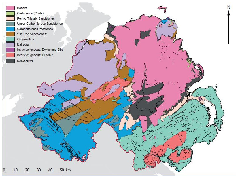
Figure 1Main Formations Hosting Groundwater (aquifers) of Northern Ireland (Wilson et al., 2023).
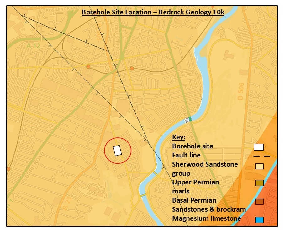
Figure 2Bedrock Geology at the borehole site (Adapted from GSNI GeoIndex).
2.1 Site Location and Hydrogeological Setting
The studied site is located within the Queen's University Belfast campus, Northern Ireland, where three boreholes were drilled to a depth of 100 m each into the lower Sherwood Sandstone Group (Figs. 1 and 2). The construction of the three boreholes was identical: a 150 mm diameter hole, cased across the first ∼30 m superficial layers (Malone sands and glacial till that date back to the Late Midlandian period of the Pleistocene epoch; approximately 25 000 to 10 000 years ago) and open (uncased) throughout the underlying ∼70 m Sherwood Sandstone Group aquifer. The Sherwood Sandstone Group was formed from fluvial deposits (typically braided fluvial system) and deposits of aeolian origin (Thompson, 1970; Holliday et al., 2008; Newell, 2018). It is present in different sedimentary basins in the UK, such as the Wessex, Cheshire, Worcester and East Irish Sea (English et al., 2024). The Triassic sedimentary rocks in Northern Ireland were formed between 248 and 205 million years ago (Ma) and have been divided into three groups: the Sherwood Sandstone Group, the Mercia Mudstone Group and the Penarth Group, with the Sherwood Sandstone Group as the base of the Triassic sequence (Table 1). The Sherwood Sandstone Group is primarily composed of red silty sandstone, with brown mudstone making up about one-third of the total thickness. The unit features sedimentary structures such as ripple cross lamination, planar cross laminations, mudflakes, and desiccation cracks (Mitchell, 2004).
The Sherwood Sandstone Group is an important aquifer for groundwater extraction in Northern Ireland, and up to 300 m is preserved beneath Belfast and the Lagan Valley (Fig. 3) at the present-day southern margin of the Larne Basin (Robins, 1996). Historically, it has supplied moderately mineralised water for drinking, provided water supply for agriculture, and industrial use (Meere et al., 2013; Kalin and Roberts, 1997) and there is significant geothermal heating, cooling and thermal storage potential (Raine and Reay, 2019). In the Lagan Valley, the aquifer is largely confined and protected from pollution by thick clay-rich glacial till (Robins, 1996; Mitchell, 2004). Its hydraulic conductivity ranges from to m s−1, and transmissivity is about m2 s−1 (Kalin and Roberts, 1997; Bennett, 1976; Robins, 1996; Yang et al., 2004; Wilson et al., 2023; Comte et al., 2017). A dual porosity system exists in the Sherwood Sandstone, yielding groundwater from both primary (intergranular) and secondary (fracture) porosity (McCann, 1990).
Table 1Litho- and Chronostratigraphy of the Permian, Triassic and Jurassic rocks in Northern Ireland (Mitchell, 2004).
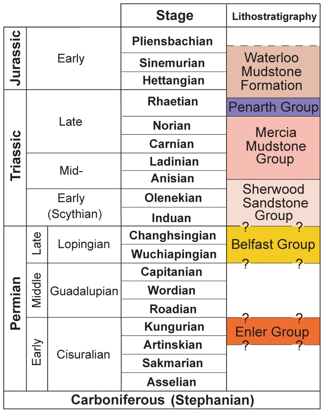
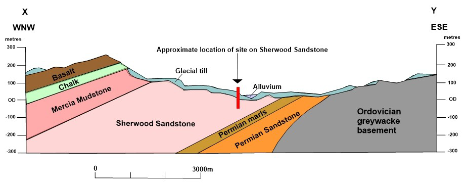
Figure 3Geological Section across the Lagan Valley (modified after Robins, 1996).
2.2 Borehole Nuclear Magnetic Resonance (BNMR)
Nuclear Magnetic Resonance (NMR) is a physical phenomenon that arises from the angular momentum and magnetic moment of the hydrogen nuclei of the water molecule (Purcell et al., 1946). The magnetic fields of these hydrogen nuclei can interact with an external magnetic field (static or dynamic). In NMR logging applications, the permanent magnets on the logging tool generate the applied static magnetic field, and for borehole nuclear magnetic resonance (BNMR), the magnetic field strength ranges from 5.75 to 47 mT (Behroozmand et al., 2015). The applied external magnetic field (Bo) causes the randomly oriented hydrogen nuclei to align themselves with the external magnetic field, and the frequency at which the nuclei precess is known as the Larmor Frequency, which ranges between 0.245 to 2 MHz and creates a secondary magnetic field. When the external magnetic field is switched off, the secondary magnetic field decays as the hydrogen nuclei return to their natural state. The NMR measurement involves recording the change in magnetisation as the system returns to equilibrium, and this time-dependent change in magnetisation contains information about the aquifer's water content and geometry of the water-filled pore spaces. See Coates et al. (1999) and Ellis and Singer (2007) for a detailed explanation of the principle of BNMR.
The process of determining porosity using BNMR involves measuring the transverse relaxation time (T2) decay curve. By integrating the amplitudes of this decay curve, the volume of water present in the pore spaces can be quantified. The measured response can be separated into two categories: bound fluid volume and free fluid volume. BNMR provides estimates of flow and storage potential in an aquifer, gives information on water content and distribution, pore structure and distribution, as well as enables estimation of permeability and hydraulic conductivity using empirical models (Vouillamoz et al., 2014). The NMR data were acquired inside the three boreholes using the NMR Services Australia (NMRSA) BNMR tool for groundwater and mining applications, which is about 15 cm long, and the cylinder/donut is about 1 cm thick. NMR measurements were performed at 0.01 m depth intervals. The acquired data were processed using global cutoff times for a clastic lithology: clay-bound volume at 3 ms and capillary-bound volume at 33 ms (bound fluid volume), and free fluid volume at 3 s in WellCAD™ – a PC software for processing and interpreting borehole logs and visualised with MATLAB (Fig. 4).
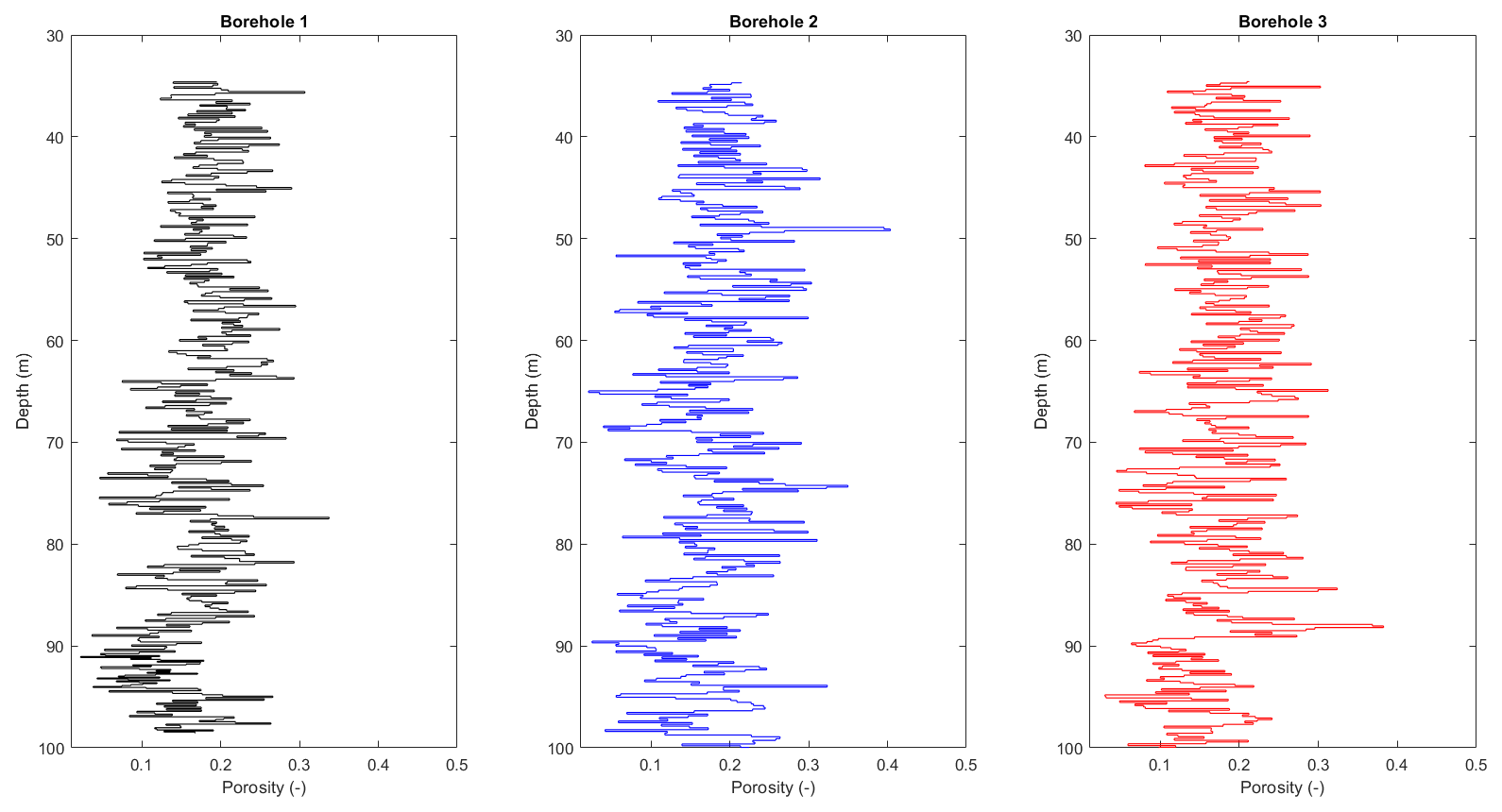
Figure 4Processed BNMR water content (total porosity) log for each borehole.
2.3 Petrophysical Models
Widely used petrophysical models, including Archie (Archie, 1942) and Waxman-Smits (Waxman and Smits, 1968) were employed in this study to provide independent estimates of porosity in the three boreholes. Geophysical logging provided models' input parameters (resistivity, EC, temperature and natural gamma) and was carried out by European Geophysical Services (EGS). Logging datasets were processed in WellCAD™. The two petrophysical models were computed and visualised using Microsoft Excel and MATLAB.
2.3.1 Archie Model
Archie carried out several experiments to show that a relationship exists between the formation factor of a completely water-saturated sedimentary rock (F) and the porosity of the rock (Φ).
where m and a are the cementation and tortuosity factors, respectively. The formation factor F is the ratio of the resistivity of a fully saturated rock and the resistivity of the water. One of the limitations of Archie's model is that it was empirically established for clean sandstone (no clay content). Taylor and Barker (2006) estimated the cementation factor of Triassic Sandstone to be 1.85, which was the value used in this study.
2.3.2 Waxman-Smits Model
Modifications have been made to the Archie model to account for the presence of clay in rocks. One of the widely accepted models is the Waxman-Smit model:
where σo is the aquifer bulk conductivity (S m−1), Φ is the porosity, m is the Archie cementation factor, σw is the pore water conductivity (S m−1), B is the equivalent counterion mobility (m2 s−1 V−1) and Qv is the excess charge per unit pore volume (C m−3). B is expressed as:
where is the maximum counterion mobility (m2 s−1 V−1). Qv is expressed as:
where CEC is the cation exchange capacity (meq g−1) and ρg is the grain density of the aquifer (g cm−3). The total CEC from a mixture of clay minerals is expressed as:
where Xi is the relative fraction of each clay minerals in the rock, CECi is the cation exchange capacity of each clay minerals and φw is the mass fraction of clay in the rock. Xi values were derived from semiquantitative whole rock and clay fraction XRD analysis of a sample from a borehole core along strike from the study boreholes and anticipated to be an equivalent stratigraphic height. The CECi values were obtained from the literature (Revil et al., 1998) – Table 2. φw values were calculated from the three boreholes gamma logs using the following linear and Larionov (Larionov, 1969) equations:
where the IGR, GRlog, GRmax and GRmin are the gamma ray index, gamma ray log reading, maximum gamma ray value and minimum gamma ray value, respectively.
Lastly, aquifer bulk conductivity and pore water conductivity were normalised to a temperature of 25 °C because temperature affects the electrical conductivity, and 25 °C is considered uniform and constant in the saturated zone using Arps (1953) equation:
where σ is the normalised conductivity, σF is the conductivity at formation temperature, and TF is the formation temperature.
Table 2CEC of the clay minerals and clay weight fraction in Glenburn 4B Borehole (Calculation of CEC based on Revil et al., 1998).
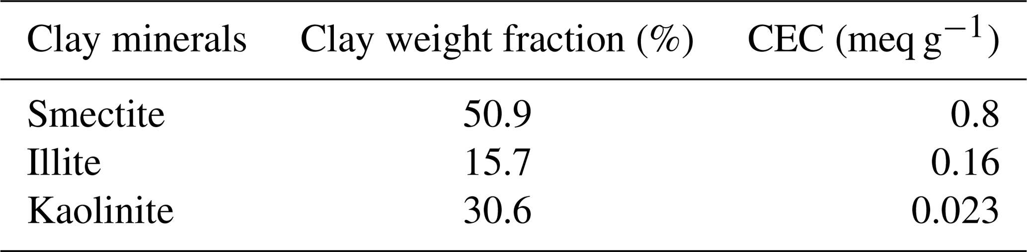
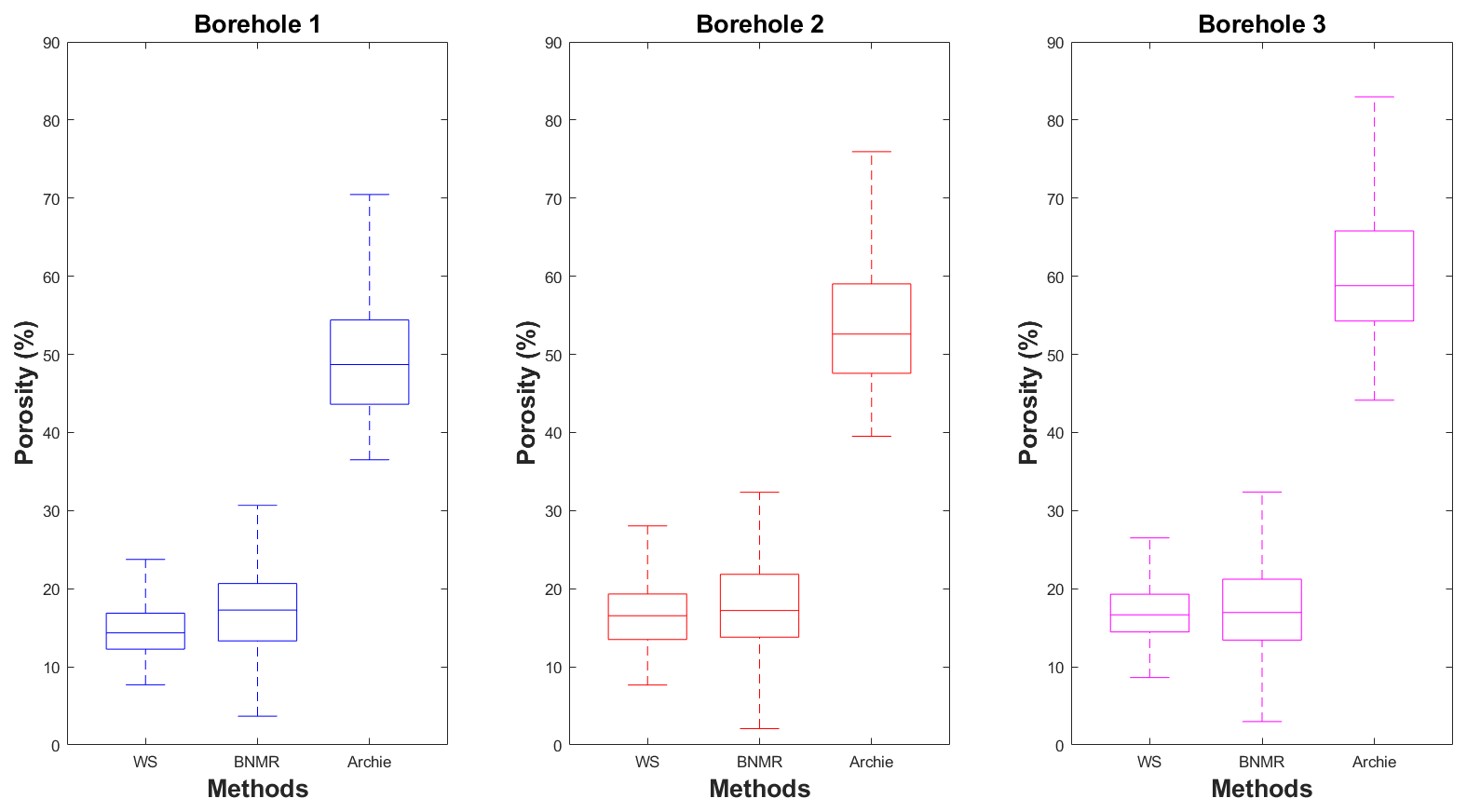
The average porosity values obtained from BNMR are 16.9 %, 17.6 %, and 17.3 % in boreholes 1, 2, and 3, respectively (Fig. 5). For the Archie model, the average porosities are 49.9 %, 54.1 %, and 60.3 % in boreholes 1, 2, and 3, respectively (Fig. 5). This is a large deviation from the BNMR porosity estimates. However, for the Waxman-Smits model, the average porosities are 14.9 %, 16.8 %, and 16.9 % in boreholes 1, 2, and 3, respectively and are similar to the BNMR results (Fig. 5). A major reason for the overestimation of porosity by the Archie model is that it does not correct for the contribution of clay minerals to the measured rock electrical conductivity therefore mistaking clay for pore water; however the Sherwood Sandstone Group has some clay contents (Comte et al., 2019; Mitchell, 2004). The XRD analysis of the Sherwood Sandstone Group samples used for this study revealed up to 3 µm wt % clay and is dominated by smectite, illite and kaolinite. Similar findings were reported for other types of aquifers with clays, such as weathered metamorphic rock aquifers (González et al., 2021).
The sandstone at the study location represents the lower part of the Sherwood Sandstone Group, which is known regionally to have a better quality (storage capacity) than the upper part. The intergranular hydraulic conductivity in certain upper and lower parts of Sherwood Sandstone Group ranges between and 10−9 m s−1 (Raine and Reay, 2019; Bennett, 1976). Porosities across the three studied boreholes did not show a noticeable increase or decrease with depth but showed varying values throughout (Fig. 4). The average porosity based on data from the Sherwood Sandstone Group across Northern Ireland is 21.3 %, but there are significant variations in porosity within individual borehole sequences and between boreholes from different sedimentary basins in Northern Ireland. Much of this variation is attributed to variable detrital clay content, cementation, grain size variation, and differences in burial-related compaction (Raine and Reay, 2019). In the upper part of the Sherwood Sandstone Group, a few kilometres East of the study site, Comte et al. (2017) estimated lower average values of effective porosity of around 10 %. The results obtained from this study provide information on the porosity of the lower parts of the Sherwood Sandstone Group, which is a productive aquifer that accounts for a large part of the area beneath Belfast. In the Sherwood Sandstone Group of Northern Ireland, faults are found to be both permeable flow pathways and baffles (Parnell et al., 2000) and differences between lab-derived permeability and that observed through pumping tests seem to support the view that it is a dual porosity reservoir, with both intergranular and fracture permeability (Robins, 1996; Wilson et al., 2023). Some intervals in the studied boreholes (e.g., 84–85 m for Borehole 1, 73–74 m for Borehole 2, and 85–86 m for Borehole 3) had BNMR-derived porosity values that suggest the presence of fractures. These open fractures could make a significant contribution to groundwater flow through the less permeable lower part of the Sherwood Sandstone Group aquifer (Fig. 3). Understanding the permeability, distribution and orientation of such fractures is an important hydrogeologic characteristic when designing an ATES system, as their presence could cause preferential flow path and thermal breakthrough between the warm and cold wells; layers with higher hydraulic conductivity in these three boreholes will allow faster movement of groundwater, which will lead to more extensive thermal plumes. However, layers with lower hydraulic conductivity will restrict flow and heat transfer. This will reduce the performance of an ATES system (Snijders and Drijver, 2016; Banks, 2009).
This study has determined the porosity using BNMR and petrophysical analysis of geophysical logs of the lower part of the Sherwood Sandstone Group from three boreholes drilled to a depth of 100 m. The porosity of the Sherwood Sandstone varies between 2.1 % and 40.4 % in the three boreholes at this location for BNMR, between 39.5 % and 88.2 % for Archie model, and between 1.2 % and 36.6 % for Waxman-Smits model. The BNMR confirms the credibility of using the Waxman-Smits model instead of the Archie model to estimate porosity in the Sherwood Sandstone formation from geophysical logs. The Archie model is well known to overestimate porosity in lithologies with clay content, and this study provided findings consistent with previous findings, further confirming Archie's model unsuitability for investigating the lower part of the Sherwood Sandstone Group in Northern Ireland. Also, the results demonstrate the consistency between BNMR and Waxman-Smits model-derived porosity and confirm the reliability of using BNMR in hydrogeological investigations. This work forms part of broader research on the impact of subsurface heterogeneity on the performance of an ATES system in the Sherwood Sandstone Group. Further research will integrate these porosity results with hydraulic conductivities from BNMR logging and pumping test data and structural and sedimentological analyses from optical televiewer (OPTV) logging data to identify fractures and different lithofacies in these three boreholes.
The BNMR and Petrophysical models porosity results are provided in the Supplement. The MATLAB code for visualising these data can be provided by the contact author upon request.
The supplement related to this article is available online at https://doi.org/10.5194/adgeo-65-189-2025-supplement.
SO, UO and JCC conceptualised the study. SO processed and interpreted the data and wrote the manuscript. UO, JCC and RR reviewed the manuscript. RG, MK and RR assisted with data collection and processing.
The contact author has declared that none of the authors has any competing interests.
Publisher’s note: Copernicus Publications remains neutral with regard to jurisdictional claims made in the text, published maps, institutional affiliations, or any other geographical representation in this paper. While Copernicus Publications makes every effort to include appropriate place names, the final responsibility lies with the authors.
This article is part of the special issue “European Geosciences Union General Assembly 2024, EGU Division Energy, Resources & Environment (ERE)”. It is a result of the EGU General Assembly 2024, Vienna, Austria, 14–19 April 2024.
The authors appreciate the technical assistance of the Geological Survey of Northern Ireland and Advanced Logic Technology (ALT) in providing access to WellCAD software. We also thank Joseph Ireland for assisting with the data collection and three anonymous reviewers who provided valuable comments.
This research has been supported by the UK Research and Innovation through the Natural Environment Research Council (NERC) QUADRAT Doctoral Training Programme (DTP) (grant no. R1079NBE/40386285).
This paper was edited by Giorgia Stasi and reviewed by Claire Bossennec, Marco Pola, and one anonymous referee.
Archie, G. E.: The electrical resistivity log as an aid in determining some reservoir characteristics, Trans. AIME, 146, 54–62, https://doi.org/10.2118/942054-G, 1942.
Arps, J. J.: The Effect of Temperature on the Density and Electrical Resistivity of Sodium Chloride Solutions, J. Petrol. Technol., 5, 17–20, https://doi.org/10.2118/953327-G, 1953.
Asif, M. and Muneer, T.: Energy supply, its demand and security issues for developed and emerging economies, Renew. Sust. Energ. Rev., 11, 1388–1413, https://doi.org/10.1016/j.rser.2005.12.004, 2007.
Bakr, M., van Oostrom, N., and Sommer, W.: Efficiency of and interference among multiple Aquifer Thermal Energy Storage systems; A Dutch case study, Renew. Energ., 60, 53–62, https://doi.org/10.1016/j.renene.2013.04.004, 2013.
Banks, D.: Thermogeological assessment of open-loop well-doublet schemes: a review and synthesis of analytical approaches, Hydrogeol. J., 17, 11–49, https://doi.org/10.1007/s10040-008-0427-6, 2009.
Behroozmand, A. A., Keating, K., and Auken, E.: A Review of the Principles and Applications of the NMR Technique for Near-Surface Characterization, Surv. Geophys., 36, 27–85, https://doi.org/10.1007/s10712-014-9304-0, 2015.
Bennett, J.: The Lagan Valley hydrogeological study, Open File Report No. 57, Geological Survey of Northern Ireland, Belfast, 1976.
British Petroleum: BP Statistical Review of World Energy, London, 4–5, 2022.
Busby, J.: Geothermal energy in sedimentary basins in the UK, Hydrogeol. J., 22, 129–141, https://doi.org/10.1007/s10040-013-1054-4, 2014.
Northern Ireland Assembly: Climate Change Act (Northern Ireland) 2022, https://www.legislation.gov.uk/nia/2022/31/contents/enacted, last access: 21 October 2024.
Coates, G. R., Xiao, L., and Prammer, M. G.: NMR logging: principles and applications, Haliburton Energy Services, Houston 234, ISBN 978-0967902609, 1999.
Comte, J.-C., Wilson, C., Ofterdinger, U., and González-Quirós, A.: Effect of volcanic dykes on coastal groundwater flow and saltwater intrusion: A field-scale multiphysics approach and parameter evaluation, Water Resour. Res., 53, 2171–2198, https://doi.org/10.1002/2016WR019480, 2017.
Comte, J.-C., Ofterdinger, U., Legchenko, A., Caulfield, J., Cassidy, R., and Mézquita González, J.: Catchment-scale heterogeneity of flow and storage properties in a weathered/fractured hard rock aquifer from resistivity and magnetic resonance surveys: implications for groundwater flow paths and the distribution of residence times, Geol. Soc. Spec. Publ., 479, 35–58, https://doi.org/10.1144/SP479.11, 2019.
De Paoli, C., Duren, T., Petitclerc, E., Agniel, M., and Dassargues, A.: Modelling Interactions between Three Aquifer Thermal Energy Storage (ATES) Systems in Brussels (Belgium), Appl. Sci., 13, 2934, https://doi.org/10.3390/app13052934, 2023.
Department for the Economy: Energy in Northern Ireland, Department for the Economy, Belfast, 123, 2022.
Dickinson, J., Buik, N., Matthews, M., and Snijders, A.: Aquifer thermal energy storage: theoretical and operational analysis, Geotechnique, 59, 249–260, https://doi.org/10.1680/geot.2009.59.3.249, 2009.
Downing, R. A. and Gray, D. A.: Geothermal resources of the United Kingdom, J. Geol. Soc., 143, 499–507, https://doi.org/10.1144/gsjgs.143.3.0499, 1986.
Ellis, D. V. and Singer, J. M.: Well logging for earth scientists, Springer, The Netherlands, 708 pp., https://doi.org/10.1007/978-1-4020-4602-5, 2007.
English, K. L., English, J. M., Moscardini, R., Haughton, P. D., Raine, R. J., and Cooper, M.: Review of Triassic Sherwood Sandstone Group reservoirs of Ireland and Great Britain and their future role in geoenergy applications, Geoenergy, 2, 2023–2042, https://doi.org/10.1144/geoenergy2023-042, 2024.
Fleuchaus, P., Godschalk, B., Stober, I., and Blum, P.: Worldwide application of aquifer thermal energy storage – A review, Renew. Sust. Energ. Rev., 94, 861–876, https://doi.org/10.1016/j.rser.2018.06.057, 2018.
González, J. A. M., Comte, J.-C., Legchenko, A., Ofterdinger, U., and Healy, D.: Quantification of groundwater storage heterogeneity in weathered/fractured basement rock aquifers using electrical resistivity tomography: Sensitivity and uncertainty associated with petrophysical modelling, J. Hydrol., 593, 125637, https://doi.org/10.1016/j.jhydrol.2020.125637, 2021.
Holliday, D., Jones, N., and McMillan, A.: Lithostratigraphical subdivision of the Sherwood Sandstone Group (Triassic) of the northeastern part of the Carlisle Basin, Cumbria and Dumfries and Galloway, UK, Scot. J. Geol., 44, 97–110, https://doi.org/10.1144/sjg44020097, 2008.
Kalin, R. and Roberts, C.: Groundwater resources in the Lagan Valley sandstone aquifer, Northern Ireland, Water Environ. J., 11, 133–139, https://doi.org/10.1111/j.1747-6593.1997.tb00104.x, 1997.
Larionov, M.: Application of factor analysis to well logging data, Earth Sci. J., 1, 113–123, 1969.
Lee, K. S.: A Review on Concepts, Applications, and Models of Aquifer Thermal Energy Storage Systems, Energies, 3, 1320–1334, https://doi.org/10.3390/en3061320, 2010.
Mahon, H., O'Connor, D., Friedrich, D., and Hughes, B.: A review of thermal energy storage technologies for seasonal loops, Energy, 239, 122207, https://doi.org/10.1016/j.energy.2021.122207, 2022.
Maliva, R. G.: Aquifer characterization techniques, Springer, Switzerland, 617 pp., https://doi.org/10.1007/978-3-319-32137-0, 2016.
McCann, N.: The subsurface geology between Belfast and Larne, Northern Ireland, Irish J. Earth Sci., 10, 157–173, https://www.jstor.org/stable/30002436 (last access: 16 February 2025), 1990.
Meere, P., MacCarthy, I., Reavy, J., Allen, A., and Higgs, K.: Geology of Ireland: a field guide, Collins Press, 372 pp., https://doi.org/10.1016/j.pgeola.2015.06.002, 2013.
Mitchell, W.: The Geology of Northern Ireland: Our Natural Foundation, Geological Survey of Northern Ireland, Belfast, 318 pp., ISBN 0-85272-454-3, 2004.
Newell, A. J.: Rifts, rivers and climate recovery: A new model for the Triassic of England, in: Proceedings of the 2018 Geologists' Association Conference, Lapworth Museum, University of Birmingham, 19–21 October 2018, 352–371, https://doi.org/10.1016/j.pgeola.2017.04.001, 2018.
Northern Ireland Executive: The Path to Net Zero, Northern Ireland Executive, Belfast, 57, 2021.
Parnell, J., Baron, M., and Boyce, A.: Controls on kaolinite and dickite distribution, Highland Boundary Fault zone, Scotland and Northern Ireland, J. Geol. Soc. London, 157, 635–640, https://doi.org/10.1144/jgs.157.3.635, 2000.
Purcell, E. M., Torrey, H. C., and Pound, R. V.: Resonance absorption by nuclear magnetic moments in a solid, Phys. Rev., 69, 37, https://doi.org/10.1103/PhysRev.69.37, 1946.
Raine, R. J. and Reay, D. M.: A review of geothermal reservoir properties of Triassic, Permian and Carboniferous sandstones in Northern Ireland, Geological Survey of Northern Ireland, Belfast, 62, 2019.
Revil, A., Cathles Iii, L., Losh, S., and Nunn, J.: Electrical conductivity in shaly sands with geophysical applications, J. Geophys. Res.-Sol. Ea., 103, 23925–23936, https://doi.org/10.1029/98JB02125, 1998.
Robins, N.: Hydrogeology of Northern Ireland, HMSO for the British Geological Society, London, 60 pp., ISBN 978-0118845243, 1996.
Snijders, A. L. and Drijver, B. C.: Open-loop heat pump and thermal energy storage systems, in: Advances in Ground-Source Heat Pump Systems, edited by: Rees, S. J., Woodhead Publishing, 247–268, https://doi.org/10.1016/B978-0-08-100311-4.00009-1, 2016.
Stemmle, R., Hammer, V., Blum, P., and Menberg, K.: Potential of low-temperature aquifer thermal energy storage (LT-ATES) in Germany, Geoth. Energ., 10, 24, https://doi.org/10.1186/s40517-022-00234-2, 2022.
Taylor, S. and Barker, R.: Modelling the DC electrical response of fully and partially saturated Permo-Triassic sandstone, Geophys. Prospect., 54, 351–367, https://doi.org/10.1111/j.1365-2478.2006.00538.x, 2006.
Thompson, D.: Sedimentation of the Triassic (Scythian) red pebbly sandstones in the Cheshire Basin and its margins, Geol. J., 7, 183–216, https://doi.org/10.1002/gj.3350070111, 1970.
UK Government: The Climate Change Act 2008 (2050 Target Amendment) Order 2019, https://www.legislation.gov.uk/uksi/2019/1056/made, last access: 4 October 2024.
Vouillamoz, J.-M., Lawson, F., Yalo, N., and Descloitres, M.: The use of magnetic resonance sounding for quantifying specific yield and transmissivity in hard rock aquifers: The example of Benin, J. Appl. Geophys., 107, 16–24, https://doi.org/10.1016/j.jappgeo.2014.05.012, 2014.
Waxman, M. H. and Smits, L.: Electrical conductivities in oil-bearing shaly sands, Soc. Petrol. Eng. J., 8, 107–122, https://doi.org/10.2118/1863-A, 1968.
Wilson, P., O Dochartaigh, B., Cooper, M., and Ni Chonchubhair, R.: Northern Ireland's groundwater environment, Geological Survey of Northern Ireland, Belfast, 126 pp., ISBN 978-0-85272-799-7, 2023.
Yang, Y. S., Cronin, A. A., Elliot, T., and Kalin, R. M.: Characterizing a heterogeneous hydrogeological system using groundwater flow and geochemical modelling, J. Hydraul. Res., 42, 147–155, https://doi.org/10.1080/00221680409500058, 2004.