Articles | Volume 64
https://doi.org/10.5194/adgeo-64-7-2024
09 Jul 2024
 | 09 Jul 2024

Criteria for selection of technology to exploit groundwater in water-scarce area in Vietnam

Trieu Duc Huy, Bui Du Duong, Pham Ba Quyen, and Vu Manh Hai
Abstract

Water extraction solutions in the high mountainous areas of Northern Vietnam commonly include rainwater harvesting, dug wells, drilled wells, groundwater springs, and hanging lakes. However, many water supply systems operate inefficiently and lack flexibility. This study established 10 criteria for selecting groundwater exploitation technology, divided into three groups: water resources, economic and technical, social, and environmental criteria. These criteria aim to identify appropriate water extraction technologies suitable for high mountainous and water-scarce regions, ensuring the long-term and efficient operation of water supply systems. The Geographic Information System (GIS) approach was utilized, integrating the criteria using the Analytical Hierarchy Process (AHP) method to select suitable water extraction technologies. The research results indicate that the evaluation criteria for determining suitable areas for implementing sustainable water extraction technologies, and the weights assigned to these criteria, ensure a consistent ratio (CR) <10 % according to the hierarchical analysis method. This article presents the results of identifying areas suitable for implementing groundwater extraction technologies using drilled wells, based on seven criteria within three groups: water resources, economic and technical, and social criteria. The GIS approach has been employed, and the criteria have been integrated using the AHP to select and determine the areas suitable for implementing groundwater extraction technologies using drilled wells.

1 Introduction

The Northern region is the largest economic territory in Vietnam, characterized by complex natural geographical conditions, making it challenging to find water sources for daily life and production. To ensure effective and sustainable long-term water exploitation, it is essential to select appropriate technology and operational management tailored to each water source condition and other relevant factors. However, determining the right technology for water extraction in high mountainous and water-scarce areas is particularly difficult and depends on numerous factors. Many studies have focused on identifying areas suitable for implementing sustainable water extraction technologies using GIS techniques. Most of these studies use index calculation methods, leveraging GIS technologies to create maps that highlight suitable areas for sustainable water extraction technology (Ghayoumian et al., 2007; Suman et al., 2018).

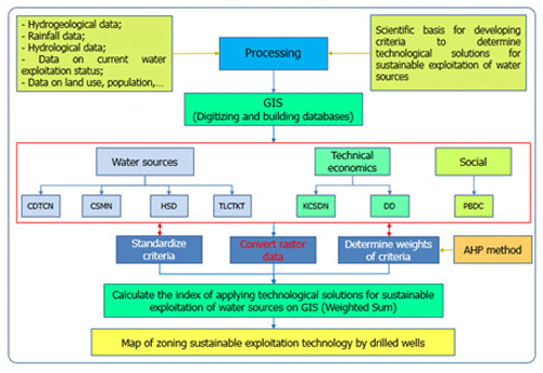
https://adgeo.copernicus.org/articles/64/7/2024/adgeo-64-7-2024-f01

Figure 1Diagram of methodology on identifying the locations applying sustainable groundwater exploitation technology solutions through drilled wells in the mountainous of the Northern area of Vietnam.

Download

2 Materials and Methods

2.1 Criteria for selecting groundwater exploitation technology in water-scarce areas in the Northern region

Scientific and practical research has established 10 criteria suitable for the study area and available data sets, divided into three groups: water source criteria, technical and economic criteria, and social criteria (Hou et al., 2017; Fanao et al., 2021; Indrani et al., 2020; Anh et al., 2018; Quyen et al., 2017). Currently, the technological solutions for exploiting groundwater in the high mountainous areas of Northern Vietnam include drilled wells, dug wells, springs, caves, and underground dams. These solutions are outlined as follows:

  • Drilled Wells: Drilled wells are the most popular solution for exploiting groundwater. They often feature submersible pumps installed to extract water. The evaluation of zoning and application of technological solutions using drilled wells is based on seven criteria: Aquifer thickness (CDTCN); Aquifer conductivity (HSD); Water depth (CSMN); Exploitable reserves (TLCTKH); Distance to water use location (KCSDN); Terrain slope (DD); Population density (PBDC).

  • Dug wells: Dug wells are a manual and common method for extracting groundwater. They typically target shallow groundwater in surface karst zones covered by partially or completely weathered sediments. These surfaces are often large and located in the lower parts of the terrain or karst valleys.

  • Springs: Exploiting groundwater from springs involves a spontaneous approach where people collect water from natural streams and water bodies with small flows, channeling it for use through troughs or pipes.

  • Caves: Groundwater exploitation in caves is popular in limestone areas, where water is pumped directly from the cave. Depending on the water level difference between the cave and the surface terrain, either a suction pump or a push pump is used. The flow rate of the suction pump depends on the allowable extraction flow and pump capacity.

  • Underground Dams: This method involves constructing dams to block the flow and raise the groundwater level in the fractured karst zone, facilitating easier groundwater extraction.

https://adgeo.copernicus.org/articles/64/7/2024/adgeo-64-7-2024-f02

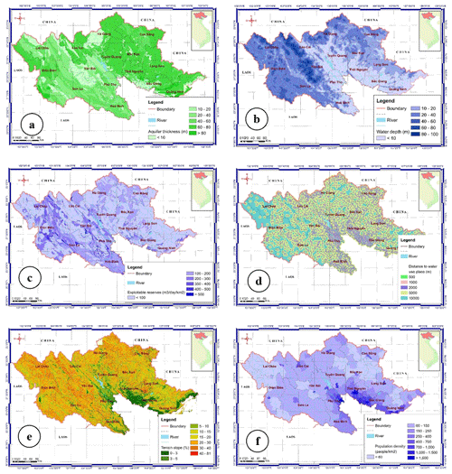
Figure 2Distribution maps of criteria's value: (a) Saturation thickness (of aquifers), (b) Depth to groundwater level, (c) Exploitable reserve, (d) Distance to the groundwater usage point, (e) Terrain slope, (f) Population density.

https://adgeo.copernicus.org/articles/64/7/2024/adgeo-64-7-2024-f03

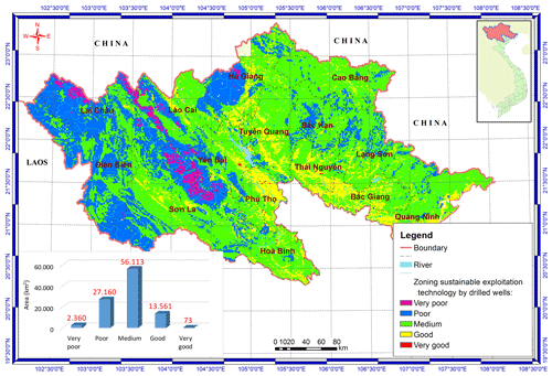
Figure 3Maps of zoning sustainable exploitation technology by drilled wells.

2.2 Identify areas to apply technological solutions for exploiting groundwater resources by drilling wells in the Northern region of Vietnam

To establish a map for applying technological solutions to the sustainable exploitation of groundwater resources using drilled wells, a multi-parameter data set provided by State-level projects was utilized by the National Center for Water Resources Planning and Investigation. The data set includes the following:

  • Water Source Criteria Group: Data on aquifer thickness, groundwater level depth, and aquifer conductivity coefficients were collected and synthesized from State-level project results. Data on exploitable groundwater reserves were calculated based on the hydrogeological parameters of aquifers (Tam et al., 2018).

  • Technical and Economic Criteria Group: To determine the distance to water use locations, technological solutions for exploiting and using groundwater sources by drilled wells in high mountainous and water-scarce areas were evaluated. The centers of administrative units at commune, district, and city levels within the study area were identified. Using the Buffer tool in ArcGIS software, the distribution range of areas relative to water use locations was calculated and determined according to established levels. Terrain slope data were determined based on the digital elevation model (DEM). Using the Slope tool in ArcGIS software, terrain slopes were classified according to division levels (Tam et al., 2018).

  • Social Criteria Group: Population density data were used to evaluate and determine technological solutions for exploiting and using groundwater sources by drilled wells. This data was synthesized from the natural area and current population status in the 2020 Statistical Yearbook of the provinces (Statistics, 2020), from which the population density ratio in the study area was calculated.

    The Geographic Information System (GIS) approach has been utilized, and the criteria have been integrated using the Analytical Hierarchy Process (AHP) method (Saaty, 1980) to select suitable water extraction technologies through drilled wells for the high mountainous and water-scarce areas.

3 Results

The spatial distribution of all seven criteria across the three groups (aquifer thickness, water depth, aquifer conductivity, exploitable reserves, distance to water use place, terrain slope, and population density) in the study area is detailed as follows:

  • Aquifer thickness: The average thickness of aquifers in the study area is divided into regions with aquifer thickness ranges as follows: <10 m, from 10 to 20 m, from 20 to 30 m, from 30 to 50 m and >50 m.

  • Water depth: The results of establishing a diagram of groundwater depth distribution in high mountainous, water-scarce areas in the Northern region have divided into areas with groundwater depth as follows: <10 m, from 10 to 20 m, from 20 to 30 m, from 30 to 50 m and >50 m.

  • Aquifer conductivity: The conductivity coefficient of aquifers is divided into the following regions: < 15 m2 d−1, from 15 to 30 m2 d−1, from 30 to 60 m2 d−1, from 60 to 90 m2 d−1 and >90 m2 d−1.

  • Exploitable reserves: The larger the exploitable reserve module of the aquifer, the richer it is in water, and the more stable the groundwater exploitation works are, and vice versa. The results of establishing the exploitable reserve module diagram of the aquifers have been divided into regions with the following values: <100 m3 d−1 km−2, from 100 to 200 m3 d−1 km−2, from 200 to 300 m3 d−1 km−2, from 300 to 500 m3 d−1 km−2 and >500 m3 d−1 km−2.

  • Distance to water use place: The distribution of areas with distance to the water use place is calculated by distance according to the following levels: <0.5 km, from 0.5 to 1 km, from 1 to 2 km, from 2 to 5 km and >5 km.

  • Terrain slope: determines whether the ground allows the construction of water exploitation works or not. Flat terrain is very favorable for the construction of water exploitation and use works, the terrain is too steep and does not allow the construction of water exploitation works. Terrain slope is divided into the following zones: <5 %, from 5 % to 10 %, from 10 % to 15 %, from 15 % to 20 % and >20 %.

  • Population density: The population density map in the study area is divided into the following levels: <100 people km−2, from 100 to 200 people km−2, from 200 to 300 people km−2, from 300 to 400 people km−2 and >400 people km−2.

Based on the data for each criterion (Fig. 2), calculations and standardizations were performed in the ArcGIS environment. The map superposition method, using the Weighted Sum tool in ArcGIS (Suman et al., 2018), was applied to determine the suitability of areas for groundwater exploitation using drilled wells. This process aimed to identify suitable areas for domestic water supply in the high mountainous and water-scarce regions of Northern Vietnam at various levels. The area of each region was calculated in ArcGIS software, and the data was exported to Excel for further processing and classification of applicability levels for each commune, ward, and town in the study area.

The results, shown in Fig. 3, indicate the following distribution of areas suitable for groundwater exploitation using drilled wells at a very sustainable (Very good) level has a total area of 73 km2 (accounting for 0.07 % of the study area), sustainable (Good) has a total area of 13 561 km2 (13.66 %), moderately sustainable (Medium) has a total area of 56 113 km2 (56.53 %), unsustainable (Poor) has a total area of 27 160 km2 (27.36 %), and very unsustainable (Very poor) with a total area of 2360 km2 (2.38 %).

4 Discussion and Conclusions

The determination of area for applying suitable groundwater exploitation technologies by wells in the mountainous, water-scarce areas in Northern Vietnam using GIS technique provided an effective solution for managing the sustainable explotation of water resources. The results show that the used criteria are suitable for the mountainous, water-scarce areas and the weights of the established criteria ensure a consistent ratio (CR < 10 %) according to the hierarchical analysis method. Additionally, the areas applying groundwater explotation technologies by wells for water supply at the levels of very sustainable and sustainable are distributed across 1895 communes in 15 provinces.

Identifying and selecting appropriate criteria and determining suitable weights is crucial for determining areas to apply technological solutions for groundwater exploitation. This study demonstrates the effectiveness of using GIS to exploit drilled wells in high mountainous and water-scarce areas in Northern Vietnam. It provides a scientific and practical basis for planning the rational exploitation and use of groundwater resources in the region. However, when implementing these technological solutions, it is essential to carefully survey hydrogeological conditions and integrate management solutions to ensure sustainable project outcomes.

Four out of seven criteria were provided by State-level projects (Aquifer thickness, Water depth, Aquifer conductivity, Exploitable reserves). Due to incomplete data coverage of the study area, we used interpolation methods to estimate these criteria in similar areas. To improve the results, further studies are needed. In the near future, a groundwater monitoring network should be established to monitor groundwater levels and quality in real-time. Additionally, satellite monitoring should be used to estimate groundwater fluctuations through land subsidence/uplift using the InSAR method.

Data availability

Data are available on request from the authors.

Author contributions

TDH and PBQ planned the research; TDH, VMH and PBQ performed the measurements; PBQ, BDD, and VMH analyzed the data and modelling; VMH and BDD wrote the manuscript.

Competing interests

The contact author has declared that none of the authors has any competing interests.

Disclaimer

Publisher’s note: Copernicus Publications remains neutral with regard to jurisdictional claims made in the text, published maps, institutional affiliations, or any other geographical representation in this paper. While Copernicus Publications makes every effort to include appropriate place names, the final responsibility lies with the authors.

Special issue statement

This article is part of the special issue “Groundwater management in the context of global change: integrating innovative approaches (EGU2024 HS8.2.1 session)”. It is a result of the EGU General Assembly 2024, Vienna, Austria, 14–19 April 2024.

Acknowledgements

This article forms and integral part of the study's result entitled “Study in proposing exploitation technologies and smart management and operation on water resources for sustainable water supply in the mountainous, water-scarce areas. Experiment in Meo Vac, Ha Giang province, Code: ĐTĐL.CN-64/21. The authors sincerely thank to Ministry of Science and Technology, National Center for Water Resources Planning and Investigation for their meaningful support.

Financial support

This research has been supported by the Ministry of Science and Technology of Vietnam (MOST) under grant no. ĐTĐL.CN-64/21. The authors would like to express their sincere thanks to anonymous reviewers for their helpful comments and review of the manuscript.

Review statement

This paper was edited by Estanislao Pujades and reviewed by two anonymous referees.

References

Anh, D. N., et al.: Report on Research and propose models and technological solutions to exploit and protect sustainable development of karst water sources to serve domestic water supply in high mountainous, water-scarce areas in the Northern region, State-level of science and technology project of Vietnam, code: ĐTĐL.CN-61/15, https://www.most.gov.vn/cchc/tin-tuc/525/15991/thong-tin-ve-ket-qua-tu-danh-gia-de-tai-nghien-cuu-de-xuat-cac-mo-hinh–giai-phap-cong-nghe-khai-thac-va-bao-ve-phat-tr...un.aspx (last access: 20 March 2024), 265 pp., 2018 (in Vietnamese) 

Fanao, M., Xiujuan, L., Changlai, X., and Wang, G.: Integration of GIS, improved entropy and improved catastrophe methods for evaluating suitable locations for well drilling in arid and semi-arid plains, Ecol. Indic., 131, 108124, https://doi.org/10.1016/j.ecolind.2021.108124, 2021. 

Ghayoumian, J., Mohseni Saravi, M., Feiznia, S., Nouri, B., and Malekian, A.: Application of GIS techniques to determine areas most suitable for artificial groundwater recharge in a coastal aquifer in southern Iran, J. Asian Earth Sci., 30, 364–374, https://doi.org/10.1016/j.jseaes.2006.11.002, 2007. 

Hou, E., Wang, J., and Chen, W.: A comparative study on groundwater spring potential analysis based on statistical index, index of entropy and certainty factors models, Geocarto Int., 33, 754–769, https://doi.org/10.1080/10106049.2017.1299801, 2017. 

Indrani, M. and Umesh, K. S.: Delineation of groundwater potential zones in a drought-prone semi-arid region of east India using GIS and analytical hierarchical process techniques, CATENA, 194, 104681, https://doi.org/10.1016/j.catena.2020.104681, 2020.  

Quyen, P. B., Minh, V. C., Nhan, D. D., Dung, D. V., Phuc, H. D., Hai, T. Q., Thu, L. N., Thuan, L. D., Huong, B. Q., and Yen, D. T. H.: Research on solutions to exploit and sustainably use water resources in the Karst high mountain areas of Northeast Vietnam. Applied experimentally in the Dong Van karst plateau, Science and technology project at Ministry of Natural resources and environment level, 221 pp., https://vista.gov.vn/news/khoa-hoc-ky-thuat-va-cong-nghe/nghien-cuu-giai-phap-khai-thac-su-dung-ben-vung-nguon-nuoc-tai-cac-vung-nui-cao-karst-dong-bac-viet-nam-1936.html (last access: 22 March 2024), 2017 (in Vietnamese). 

Saaty, T. L.: The analytic hierarchy process (AHP), J. Oper. Res. Soc., 41.11, 1073–1076, 1980. 

Statistical Yearbooks of Bac Kan, Bac Giang, Cao Bang, Dien Bien, Ha Giang, Hoa Binh, Lai Chau, Lang Son, Lao Cai, Phu Tho, Quang Ninh, Son La, Thai Nguyen, Tuyen Quang, Yen Bai provinces, Statistics Office, https://www.gso.gov.vn/du-lieu-va-so-lieu-thong-ke/2021/07/nien-giam-thong-ke-2021/ (last access: 22 March 2024), 2020 (in Vietnamese). 

Suman, P., Pula, M., and Subhash, C. M.: Delineation of groundwater potential zone for sustainable development: A case study from Ganga Alluvial Plain covering Hooghly district of India using remote sensing, geographic information system and analytic hierarchy process, J. Clean. Prod., 172, 2485–2502, https://doi.org/10.1016/j.jclepro.2017.11.161, 2018. 

Tam, V. T., Nhan, P. Q., Tu, N. T., Toan, D. N., Ha, N. T., Cong P. V., Toan, B. V., Thuc, P. Q., Giang, N. V., and Tuyen, L. V.: Report on Revising – Establishing a map of ground water resources at a scale of 1:200000 for provinces nationwide, Ministry-level of Natural resources and environment project, Hanoi, Vietnam, 132 pp., 2018 (in Vietnamese).