Articles | Volume 64
https://doi.org/10.5194/adgeo-64-19-2024
20 Aug 2024
 | 20 Aug 2024

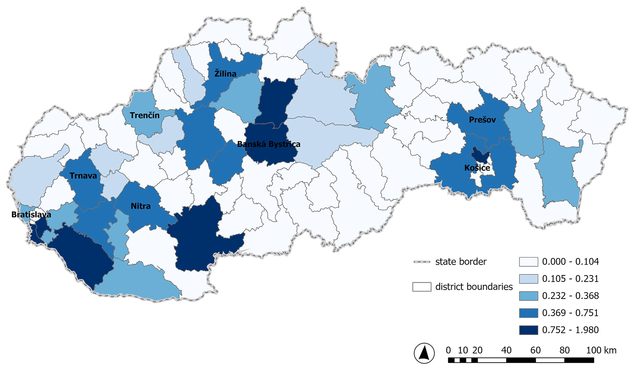
The spatial distribution of surface and groundwater abstractions in Slovakia in the period 2013–2022 vs 2022

Katarína Kotríková, Ľubica Lovásová, Michaela Kurejová Stojkovová, and Valéria Slivová
Abstract

In recent years, the impacts of climate change have become increasingly apparent; Slovakia has witnessed a rise in extreme weather conditions caused by climate change. To address these challenges, we analyze and prepare documents focused on monitoring and issuing drought warnings. These documents, including Slovakia's water resource balance, serve as fundamental materials for water management planning. The water resource balance assesses the relationship between water demands and available resources in the past year, identifying areas and times where water demands exceed supply. Additionally, our analysis provides a detailed map of surface and groundwater abstractions across Slovakia, categorizing total and individual abstractions by sector (e.g., public water supply systems, agriculture, and industry). We present surface and groundwater abstraction averages for the period of the last decade 2013–2022, along with its spatial distribution in Slovak districts. This comprehensive approach enables us to better understand and manage our water resources effectively.

1 Introduction

Many countries have documents and papers how the governments will reform the way we manage water abstraction, to protect the environment and improve access to water (e.g., Water abstraction plan 2017 in UK (GOV.UK, 2024)). In Slovakia, the water resource balance is a significant document for water management planning and collecting data on the impact of human activity. The Slovakia's water resource balance (Slovak Hydrometeorological Institute (SHMÚ) Publications, 2024) includes actual abstractions that are reported yearly in accordance with Sect. 6 of the Water Act no. 364/2004 Coll: “A person who takes surface water or groundwater from a single abstraction point in an amount of more than 15 000 m3 yr−1 or more than 1250 m3 per month for personal needs of a household and someone who takes surface water or groundwater on the basis of a permit according to Sect. 21 or uses a special water.”

https://adgeo.copernicus.org/articles/64/19/2024/adgeo-64-19-2024-f01

Figure 1The spatial distribution of the amount of surface water and groundwater abstraction averages (m3 s−1) in Slovak districts for the period 2013–2022.

https://adgeo.copernicus.org/articles/64/19/2024/adgeo-64-19-2024-f02

Figure 2The amount of surface water and groundwater abstraction averages (m3 s−1) for the period 2013–2022 and their shares in individual categories of abstractions (public water supply systems, agriculture, industry).

2 Data and Methods

These reported abstractions are processed and evaluated in the Slovakia's water resource balance at the river basin's level. For the purposes of this paper, we processed the average annual values of abstractions in individual districts according to the purpose of their use. The data were processed for the 10-year long period 2013–2022 as long-term average values in every district for every sector (e.g, public water supply system, agriculture, and industry), which were subsequently compared with the consumption values in 2022. The data were processed in the spreadsheet editor MS Excel and then visualized using the geographic information system ArcGIS Pro.

3 Results

3.1 Abstraction averages for the period 2013–2022

We present surface and groundwater abstraction averages for the period of the last decade 2013–2022 (Fig. 1). According to the analysis, over 48 % of surface and groundwater abstractions are utilized for public water supply systems, while approximately 46 % of these abstractions are used for industrial purposes. 75 % of surface water abstractions are used for industrial purposes, and 70 % of groundwater abstractions are utilized for public water supply systems (Fig. 2).

3.2 Abstraction averages in 2022

In the year 2022 (Fig. 3), we can observe an increase of 1.7 % in total abstractions compared to the period 2013–2022. According to the analysis, over 51 % of surface and groundwater abstractions are utilized for public water supply systems, while approximately 44 % of these abstractions are used for industrial purposes. 72 % of surface water abstractions are used for industrial purposes, and also 72 % of groundwater abstractions are utilized for public water supply systems (Fig. 4).

https://adgeo.copernicus.org/articles/64/19/2024/adgeo-64-19-2024-f03

Figure 3The spatial distribution of the amount of surface water and groundwater abstraction averages (m3 s−1) in Slovak districts in 2022.

https://adgeo.copernicus.org/articles/64/19/2024/adgeo-64-19-2024-f04

Figure 4The amount of surface water and groundwater abstraction averages (m3 s−1) in Slovak districts in 2022 and their shares in individual categories of abstractions (public water supply systems, agriculture, industry).

After analyzing the data, we have observed an increase in the abstraction averages for the needs of public water supply systems (3 %) and a decrease for industrial purposes (2.8 %) in 2022 against the period 2013–2022. Our analysis aims to include maps of water abstractions in the balance profiles for the past year in the water resource balance.

4 Conclusions

In this study we analysed abstraction averages of surface water and groundwater for the needs of public water supply systems, agriculture and industry in every Slovak district. The analysis was made for the 10-year long period 2013–2020 long-term average values and for the calendar year 2022. We used geographic information systems for visualization, for the first time, which gave us a much more accurate picture of the spatial distribution of abstractions of surface water and groundwater. We assumed that the largest abstractions are in the vicinity of large cities. The analysis also showed that more surface water were used for agricultural purposes and more groundwater were used for the needs of water supply systems.

In the area of water use, it is necessary to optimize abstractions, manage water efficiently, reuse rainwater and treated wastewater, support the use of water-saving technologies and procedures, especially with regard to climate change and its effects. In the future, an unlimited amount of water will not be available everywhere, at any time for every user and consumer in the required quality, we will need to regulate water intake and use in times of water shortage or drought (Ministry of the Environment of the Slovak republic, 2024). This study is just a minor part of the base analysis to study drought and water scarcity in our country. By comparing the water abstraction maps with the processed drought vulnerability maps (Jeneiová et al., 2024), we can identify potentially at-risk areas of water scarcity in the country.

Data availability

The research data are publicly accessible on the official website of the Slovak Hydrometeorological Institute (https://www.shmu.sk/en/?page=1834, Slovak Hydrometeorological Institute (SHMÚ) Publications, 2024).

Author contributions

KK is responsible for formal analysis, methodology, validation, visualization, and writing of original draft preparation, review and editing. ĽL is responsible for conceptualization, data curation, investigation, methodology, project administration, supervision, and validation. MKS is responsible for conceptualization and data curation. VS is responsible for conceptualization, data curation, investigation, methodology, project administration, supervision, validation, and writing – editing.

Competing interests

The contact author has declared that none of the authors has any competing interests.

Disclaimer

Publisher’s note: Copernicus Publications remains neutral with regard to jurisdictional claims made in the text, published maps, institutional affiliations, or any other geographical representation in this paper. While Copernicus Publications makes every effort to include appropriate place names, the final responsibility lies with the authors.

Special issue statement

This article is part of the special issue “Groundwater management in the context of global change: integrating innovative approaches (EGU2024 HS8.2.1 session)”. It is a result of the EGU General Assembly 2024, Vienna, Austria, 14–19 April 2024.

Review statement

This paper was edited by Estanislao Pujades and reviewed by Ishita Bhatnagar and one anonymous referee.

References

GOV.UK Publications: https://www.gov.uk/government/publications/water-abstraction-plan-2017/water-abstraction-plan, last access: 20 June 2024. 

Jeneiova, K., Blaskovicova, L., Kotrikova, K., Danacova, Z., and Poorova, J.: Assessment of drought prone areas in Slovakia according to the changes in the long-term mean discharges, EGU General Assembly 2024, Vienna, Austria, 14–19 Apr 2024, EGU24-1478, https://doi.org/10.5194/egusphere-egu24-1478, 2024. 

Ministry of the Environment of the Slovak republic Publications: https://www.minzp.sk/files/sekcia-vod/koncepcia-vodnej-politiky/koncepcia-vodnej-politiky.pdf, last access: 18 June 2024. 

Slovak Hydrometeorological Institute (SHMÚ) Publications: https://www.shmu.sk/en/?page=1834, last access: 5 April 2024. 

Download
Short summary
The impacts of climate change have become increasingly apparent, even in Slovakia. To monitor and issue drought warnings, we conduct analyses and prepare documents. Our analysis, covering the last decade (2013-2022) and 2022, provides a map of surface and groundwater abstractions throughout Slovakia, categorized by sector. This comprehensive approach enables us to better understand and manage our water resources effectively.